Geospatial based AHP analysis for habitat suitability of elephants and the effects of human elephant conflict in a tropical forest of Western Ghats in India
P. Vineetha, S. Sarun, S. Selvakumar, Reghunath Rajesh
{"title":"Geospatial based AHP analysis for habitat suitability of elephants and the effects of human elephant conflict in a tropical forest of Western Ghats in India","authors":"P. Vineetha, S. Sarun, S. Selvakumar, Reghunath Rajesh","doi":"10.1007/s10344-024-01834-y","DOIUrl":null,"url":null,"abstract":"<p>In Kerala, human-elephant conflicts (HEC) are reported in almost all parts of the Western Ghats region, exceptionally high in Wayanad. In recent years, there has been a notable surge in HEC occurrences throughout the state, leading to the loss of property, animals, and life. The dependency of humans on enclosures, the transformation of natural areas into plantations, and the fragmentation of natural ecosystems are the main reasons for the escalating conflict between people and elephants. As a result, it is necessary to study the suitability of habitat for elephants and ensure their conservation. The study aims to identify suitable elephant habitats in the Wayanad Wildlife Sanctuary using geospatial data based on their known association with environmental variables. This study employs the Analytic Hierarchy Process (AHP), an approach to determining the weightings of individual parameters in assessing habitat suitability. The analysis findings indicated that the central portion of the study area within the Sultan Bathery (43.63 sq. km), range represents the most suitable area for elephant habitat followed by Kurichat (33.59 sq. km) and Tholpetti (19.45 sq. km). The final output of the study, the Habitat Suitability Map was validated by adding the human-elephant conflict locational data, which illustrates that the Kurichiat range recorded the highest HEC conflict (50%), followed by Muthanga (29%), Sulthan Bathery (12%), and Tholpetti (9%). The map could assist in managing, conserving, and protecting forest resources and aid in decision-making activities.</p>","PeriodicalId":51044,"journal":{"name":"European Journal of Wildlife Research","volume":"245 1","pages":""},"PeriodicalIF":1.8000,"publicationDate":"2024-07-23","publicationTypes":"Journal Article","fieldsOfStudy":null,"isOpenAccess":false,"openAccessPdf":"","citationCount":"0","resultStr":null,"platform":"Semanticscholar","paperid":null,"PeriodicalName":"European Journal of Wildlife Research","FirstCategoryId":"99","ListUrlMain":"https://doi.org/10.1007/s10344-024-01834-y","RegionNum":3,"RegionCategory":"生物学","ArticlePicture":[],"TitleCN":null,"AbstractTextCN":null,"PMCID":null,"EPubDate":"","PubModel":"","JCR":"Q3","JCRName":"ECOLOGY","Score":null,"Total":0}
引用次数: 0
Abstract
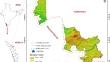
In Kerala, human-elephant conflicts (HEC) are reported in almost all parts of the Western Ghats region, exceptionally high in Wayanad. In recent years, there has been a notable surge in HEC occurrences throughout the state, leading to the loss of property, animals, and life. The dependency of humans on enclosures, the transformation of natural areas into plantations, and the fragmentation of natural ecosystems are the main reasons for the escalating conflict between people and elephants. As a result, it is necessary to study the suitability of habitat for elephants and ensure their conservation. The study aims to identify suitable elephant habitats in the Wayanad Wildlife Sanctuary using geospatial data based on their known association with environmental variables. This study employs the Analytic Hierarchy Process (AHP), an approach to determining the weightings of individual parameters in assessing habitat suitability. The analysis findings indicated that the central portion of the study area within the Sultan Bathery (43.63 sq. km), range represents the most suitable area for elephant habitat followed by Kurichat (33.59 sq. km) and Tholpetti (19.45 sq. km). The final output of the study, the Habitat Suitability Map was validated by adding the human-elephant conflict locational data, which illustrates that the Kurichiat range recorded the highest HEC conflict (50%), followed by Muthanga (29%), Sulthan Bathery (12%), and Tholpetti (9%). The map could assist in managing, conserving, and protecting forest resources and aid in decision-making activities.
期刊介绍:
European Journal of Wildlife Research focuses on all aspects of wildlife biology. Main areas are: applied wildlife ecology; diseases affecting wildlife population dynamics, conservation, economy or public health; ecotoxicology; management for conservation, hunting or pest control; population genetics; and the sustainable use of wildlife as a natural resource. Contributions to socio-cultural aspects of human-wildlife relationships and to the history and sociology of hunting will also be considered.

 求助内容:
求助内容: 应助结果提醒方式:


