Yuval Sadeh, Xuan Zhu, David Dunkerley, Jeffrey P. Walker, Yang Chen, Karine Chenu
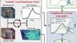
{"title":"Versatile crop yield estimator","authors":"Yuval Sadeh, Xuan Zhu, David Dunkerley, Jeffrey P. Walker, Yang Chen, Karine Chenu","doi":"10.1007/s13593-024-00974-4","DOIUrl":null,"url":null,"abstract":"<div><p>Accurate production estimates, months before the harvest, are crucial for all parts of the food supply chain, from farmers to governments. While methods have been developed to use satellite data to monitor crop development and production, they typically rely on official crop statistics or ground-based data, limiting their application to the regions where they were calibrated. To address this issue, a new method called VeRsatile Crop Yield Estimator (VeRCYe) has been developed to estimate wheat yield at the pixel and field levels using satellite data and process-based crop models. The method uses the Leaf Area Index (LAI) as the linking variable between remotely sensed data and APSIM crop model simulations. In this process, the sowing dates of each field were detected (RMSE = 2.6 days) using PlanetScope imagery, with PlanetScope and Sentinel-2 data fused into a daily 3 m LAI dataset, enabling VeRCYe to overcome the traditional trade-off between satellite data that has either high temporal or high spatial resolution. The method was evaluated using 27 wheat fields across the Australian wheatbelt, covering a wide range of pedo-climatic conditions and farm management practices across three growing seasons. VeRCYe accurately estimated field-scale yield (R<sup>2</sup> = 0.88, RMSE = 757 kg/ha) and produced 3 m pixel size yield maps (R<sup>2</sup> = 0.32, RMSE = 1213 kg/ha). The method can potentially forecast the final yield (R<sup>2</sup> = 0.78–0.88) about 2 months before the harvest. Finally, the harvest dates of each field were detected from space (RMSE = 2.7 days), indicating when and where the estimated yield would be available to be traded in the market. VeRCYe can estimate yield without ground calibration, be applied to other crop types, and used with any remotely sensed LAI information. This model provides insights into yield variability from pixel to regional scales, enriching our understanding of agricultural productivity.</p></div>","PeriodicalId":7721,"journal":{"name":"Agronomy for Sustainable Development","volume":"44 4","pages":""},"PeriodicalIF":6.7000,"publicationDate":"2024-07-22","publicationTypes":"Journal Article","fieldsOfStudy":null,"isOpenAccess":false,"openAccessPdf":"https://link.springer.com/content/pdf/10.1007/s13593-024-00974-4.pdf","citationCount":"0","resultStr":null,"platform":"Semanticscholar","paperid":null,"PeriodicalName":"Agronomy for Sustainable Development","FirstCategoryId":"97","ListUrlMain":"https://link.springer.com/article/10.1007/s13593-024-00974-4","RegionNum":1,"RegionCategory":"农林科学","ArticlePicture":[],"TitleCN":null,"AbstractTextCN":null,"PMCID":null,"EPubDate":"","PubModel":"","JCR":"Q1","JCRName":"AGRONOMY","Score":null,"Total":0}
引用次数: 0
Abstract
Accurate production estimates, months before the harvest, are crucial for all parts of the food supply chain, from farmers to governments. While methods have been developed to use satellite data to monitor crop development and production, they typically rely on official crop statistics or ground-based data, limiting their application to the regions where they were calibrated. To address this issue, a new method called VeRsatile Crop Yield Estimator (VeRCYe) has been developed to estimate wheat yield at the pixel and field levels using satellite data and process-based crop models. The method uses the Leaf Area Index (LAI) as the linking variable between remotely sensed data and APSIM crop model simulations. In this process, the sowing dates of each field were detected (RMSE = 2.6 days) using PlanetScope imagery, with PlanetScope and Sentinel-2 data fused into a daily 3 m LAI dataset, enabling VeRCYe to overcome the traditional trade-off between satellite data that has either high temporal or high spatial resolution. The method was evaluated using 27 wheat fields across the Australian wheatbelt, covering a wide range of pedo-climatic conditions and farm management practices across three growing seasons. VeRCYe accurately estimated field-scale yield (R2 = 0.88, RMSE = 757 kg/ha) and produced 3 m pixel size yield maps (R2 = 0.32, RMSE = 1213 kg/ha). The method can potentially forecast the final yield (R2 = 0.78–0.88) about 2 months before the harvest. Finally, the harvest dates of each field were detected from space (RMSE = 2.7 days), indicating when and where the estimated yield would be available to be traded in the market. VeRCYe can estimate yield without ground calibration, be applied to other crop types, and used with any remotely sensed LAI information. This model provides insights into yield variability from pixel to regional scales, enriching our understanding of agricultural productivity.
期刊介绍:
Agronomy for Sustainable Development (ASD) is a peer-reviewed scientific journal of international scope, dedicated to publishing original research articles, review articles, and meta-analyses aimed at improving sustainability in agricultural and food systems. The journal serves as a bridge between agronomy, cropping, and farming system research and various other disciplines including ecology, genetics, economics, and social sciences.
ASD encourages studies in agroecology, participatory research, and interdisciplinary approaches, with a focus on systems thinking applied at different scales from field to global levels.
Research articles published in ASD should present significant scientific advancements compared to existing knowledge, within an international context. Review articles should critically evaluate emerging topics, and opinion papers may also be submitted as reviews. Meta-analysis articles should provide clear contributions to resolving widely debated scientific questions.
 求助内容:
求助内容: 应助结果提醒方式:


