{"title":"The Geoheritage of Madeira: Implications for Natural Heritage and Geotourism","authors":"Paul Sotiriou, Pedro Nunes","doi":"10.1007/s12371-024-00982-6","DOIUrl":null,"url":null,"abstract":"<p>The island of Madeira forms part of the Madeira Archipelago, an Autonomous Region of Portugal, in the NE Atlantic Ocean. The Madeira Archipelago was built on 140-million-year-old oceanic crust. The exposed geology of Madeira is comprised of the Miocene (> 5.6 million years old) Basal (Inferior), Pleistocene-Miocene (1.8–5.6 million years old) Intermediate Volcanic, Pleistocene (0.7–1.8 million years old) Upper (Superior) Volcanic, and Holocene-Pleistocene (0.007-0.7 million years old) Upper (Superior) Volcanic complexes, generating the landforms and landscapes for which the island is renowned. There are at least 17 geosites on Madeira, including those in the Ponta de São Lourenço, Porto da Cruz, São Vicente Valley, Pico Ruivo, and Ponta da Cruz areas. Geotourism is not as well developed as cultural or biodiversity tourism on Madeira, however, it represents another way for tourists to explore the island’s natural heritage if done in a sustainable manner. Future studies are required to better delineate and set up georoutes on Madeira, particularly in the Ponta de São Lourenço, Porto da Cruz, and São Vicente Valley areas. It is envisaged that the aforementioned geosites could be linked by a single georoute around Madeira, the Madeira Georoute. Further investigation of the geosites identified by this study is required to ensure that these sites are managed and conserved, thereby protecting the geoheritage of Madeira. Geoconservation, sustainable tourism and the cooperation between the public and government authorities (including geologists) are required to improve geotourism on Madeira. The application of the Inventario Español de Lugares de Interés Geológico (IELIG) and Geosite Assessment (GA) models are required to assess and manage threats to Madeira’s geoheritage sites. Such threats include coastal erosion and human activities, such as mass tourism and urban expansion. It is proposed that the government of the Autonomous Region of Madeira in consultation with local and regional stakeholders should submit an application to create a UNESCO Global Geopark on the island of Madeira. This territorial sustainable development approach should be implemented based on the principles of geotourism, geoconservation, and geoeducation.</p>","PeriodicalId":48924,"journal":{"name":"Geoheritage","volume":"10 1","pages":""},"PeriodicalIF":2.4000,"publicationDate":"2024-07-04","publicationTypes":"Journal Article","fieldsOfStudy":null,"isOpenAccess":false,"openAccessPdf":"","citationCount":"0","resultStr":null,"platform":"Semanticscholar","paperid":null,"PeriodicalName":"Geoheritage","FirstCategoryId":"89","ListUrlMain":"https://doi.org/10.1007/s12371-024-00982-6","RegionNum":2,"RegionCategory":"地球科学","ArticlePicture":[],"TitleCN":null,"AbstractTextCN":null,"PMCID":null,"EPubDate":"","PubModel":"","JCR":"Q2","JCRName":"GEOSCIENCES, MULTIDISCIPLINARY","Score":null,"Total":0}
引用次数: 0
Abstract
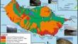
The island of Madeira forms part of the Madeira Archipelago, an Autonomous Region of Portugal, in the NE Atlantic Ocean. The Madeira Archipelago was built on 140-million-year-old oceanic crust. The exposed geology of Madeira is comprised of the Miocene (> 5.6 million years old) Basal (Inferior), Pleistocene-Miocene (1.8–5.6 million years old) Intermediate Volcanic, Pleistocene (0.7–1.8 million years old) Upper (Superior) Volcanic, and Holocene-Pleistocene (0.007-0.7 million years old) Upper (Superior) Volcanic complexes, generating the landforms and landscapes for which the island is renowned. There are at least 17 geosites on Madeira, including those in the Ponta de São Lourenço, Porto da Cruz, São Vicente Valley, Pico Ruivo, and Ponta da Cruz areas. Geotourism is not as well developed as cultural or biodiversity tourism on Madeira, however, it represents another way for tourists to explore the island’s natural heritage if done in a sustainable manner. Future studies are required to better delineate and set up georoutes on Madeira, particularly in the Ponta de São Lourenço, Porto da Cruz, and São Vicente Valley areas. It is envisaged that the aforementioned geosites could be linked by a single georoute around Madeira, the Madeira Georoute. Further investigation of the geosites identified by this study is required to ensure that these sites are managed and conserved, thereby protecting the geoheritage of Madeira. Geoconservation, sustainable tourism and the cooperation between the public and government authorities (including geologists) are required to improve geotourism on Madeira. The application of the Inventario Español de Lugares de Interés Geológico (IELIG) and Geosite Assessment (GA) models are required to assess and manage threats to Madeira’s geoheritage sites. Such threats include coastal erosion and human activities, such as mass tourism and urban expansion. It is proposed that the government of the Autonomous Region of Madeira in consultation with local and regional stakeholders should submit an application to create a UNESCO Global Geopark on the island of Madeira. This territorial sustainable development approach should be implemented based on the principles of geotourism, geoconservation, and geoeducation.
期刊介绍:
The Geoheritage journal is an international journal dedicated to discussing all aspects of our global geoheritage, both in situ and portable. The journal will invite all contributions on the conservation of sites and materials - use, protection and practical heritage management - as well as its interpretation through education, training and tourism.
The journal wishes to cover all aspects of geoheritage and its protection. Key topics are:
- Identification, characterisation, quantification and management of geoheritage;
- Geodiversity and geosites;
- On-site science, geological and geomorphological research:
- Global scientific heritage - key scientific geosites, GSSPs, stratotype conservation
and management;
- Scientific research and education, and the promotion of the geosciences thereby;
- Conventions, statute and legal instruments, national and international;
- Integration of biodiversity and geodiversity in nature conservation and land-use
policies;
- Geological heritage and Environmental Impact Assessment studies;
- Geological heritage, sustainable development, community action, practical initiatives and tourism;
- Geoparks: creation, management and outputs;
- Conservation in the natural world, Man-made and natural impacts, climate change;
- Geotourism definitions, methodologies, and case studies;
- International mechanisms for conservation and popularisation - World Heritage Sites,
National Parks etc.;
- Materials, data and people important in the history of science, museums, collections
and all portable geoheritage;
- Education and training of geoheritage specialists;
- Pedagogical use of geological heritage - publications, teaching media, trails, centres,
on-site museums;
- Linking the United Nations Decade of Education for Sustainable Development (2005- 2014) with geoconservation.
 求助内容:
求助内容: 应助结果提醒方式:


