N. N. Alekseeva, A. I. Bancheva, Yu. S. Greenfeldt, L. A. Petrov, D. A. Tretyachenko
{"title":"Estimating Carbon Emissions Resulting from Land-Use Changes at Global and Regional Levels in Foreign Research","authors":"N. N. Alekseeva, A. I. Bancheva, Yu. S. Greenfeldt, L. A. Petrov, D. A. Tretyachenko","doi":"10.1134/s1875372824700057","DOIUrl":null,"url":null,"abstract":"<h3 data-test=\"abstract-sub-heading\">Abstract</h3><p>The purpose of this article is to summarize approaches and methods used abroad for estimating carbon emissions resulting from land-use changes on global and regional levels. To understand the place of this topic in modern geoecology, an analysis of bibliometric indicators has been carried out based on the Scopus abstract and citation database. There has been a significant increase in publications on the research results of carbon emissions and absorption under the influence of land use around the world since the early 2000s, with over 200 articles currently published per year. The leading countries in terms of publication activity include China, the United States, Germany, Great Britain, and Brazil, with the Chinese Academy of Sciences being the leader among organizations. The present-day research into carbon balance changes under the impact of land-use change is based on detecting changes in land cover in the spatiotemporal aspect using advanced geoinformation technologies and on modeling carbon fluxes through the use of precise data consistent with the approaches 2–3 of the Intergovernmental Panel on Climate Change methodology. It has been established that most of the studies by leading scientific centers have common algorithm and stages. This article provides a description of these stages, namely, the methods and specific tools used, and it identifies their advantages and disadvantages. The general research algorithm includes, at the first stage, an assessment of the dynamics of land-use/land-cover change for different time spans, then carbon balance modeling as a result of land-use changes, and the development of regional policy measures on this basis. National nuances in the application of methods and initial data are also revealed (cases of China, Brazil, etc.). It is concluded that it is necessary to further improve methods in the field of accuracy of land-use/land-cover classifications and timeliness of detecting its dynamics, as well as the assessment of carbon stocks. These factors determine specific practical actions in the field of regional planning and the development of offset measures under the climate policy.</p>","PeriodicalId":44739,"journal":{"name":"Geography and Natural Resources","volume":"35 1","pages":""},"PeriodicalIF":0.4000,"publicationDate":"2024-07-04","publicationTypes":"Journal Article","fieldsOfStudy":null,"isOpenAccess":false,"openAccessPdf":"","citationCount":"0","resultStr":null,"platform":"Semanticscholar","paperid":null,"PeriodicalName":"Geography and Natural Resources","FirstCategoryId":"1085","ListUrlMain":"https://doi.org/10.1134/s1875372824700057","RegionNum":0,"RegionCategory":null,"ArticlePicture":[],"TitleCN":null,"AbstractTextCN":null,"PMCID":null,"EPubDate":"","PubModel":"","JCR":"Q4","JCRName":"GEOGRAPHY","Score":null,"Total":0}
引用次数: 0
Abstract
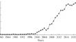
The purpose of this article is to summarize approaches and methods used abroad for estimating carbon emissions resulting from land-use changes on global and regional levels. To understand the place of this topic in modern geoecology, an analysis of bibliometric indicators has been carried out based on the Scopus abstract and citation database. There has been a significant increase in publications on the research results of carbon emissions and absorption under the influence of land use around the world since the early 2000s, with over 200 articles currently published per year. The leading countries in terms of publication activity include China, the United States, Germany, Great Britain, and Brazil, with the Chinese Academy of Sciences being the leader among organizations. The present-day research into carbon balance changes under the impact of land-use change is based on detecting changes in land cover in the spatiotemporal aspect using advanced geoinformation technologies and on modeling carbon fluxes through the use of precise data consistent with the approaches 2–3 of the Intergovernmental Panel on Climate Change methodology. It has been established that most of the studies by leading scientific centers have common algorithm and stages. This article provides a description of these stages, namely, the methods and specific tools used, and it identifies their advantages and disadvantages. The general research algorithm includes, at the first stage, an assessment of the dynamics of land-use/land-cover change for different time spans, then carbon balance modeling as a result of land-use changes, and the development of regional policy measures on this basis. National nuances in the application of methods and initial data are also revealed (cases of China, Brazil, etc.). It is concluded that it is necessary to further improve methods in the field of accuracy of land-use/land-cover classifications and timeliness of detecting its dynamics, as well as the assessment of carbon stocks. These factors determine specific practical actions in the field of regional planning and the development of offset measures under the climate policy.
期刊介绍:
Geography and Natural Resources publishes information on research results in the field of geographical studies of nature, the economy, and the population. It provides ample coverage of the geographical aspects related to solving major economic problems, with special emphasis on regional nature management and environmental protection, geographical forecasting, integral regional research developments, modelling of natural processes, and on the advancement of mapping techniques. The journal publishes contributions on monitoring studies, geographical research abroad, as well as discussions on the theory of science.
 求助内容:
求助内容: 应助结果提醒方式:


