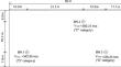
{"title":"Identification of Underground Cavities Using Seismic Wave Methods in Geostatistical Environment","authors":"Parnia Dolatyari, Hossein Rahnema, Sohrab Mirassi","doi":"10.1007/s13369-024-09206-z","DOIUrl":null,"url":null,"abstract":"<p>The stability of ground structures is severely threatened by underground anomalies, such as cavities, so accurate identification of them prior to the construction process is vital. Meanwhile, the detection of underground cavities using seismic wave methods, which are developing rapidly, is a challenging task for which various approaches have been found. This paper numerically models a site and simulates geophones horizontally and vertically to more accurately identify the location of cavities and some factors in their identification. For this purpose, a real site with three drilled boreholes is considered and the value of variable soil parameters is estimated using the Ordinary Co-Kriging (OCK) geostatistical method and the Python programming language, the site and tests are modeled by the finite element method (FEM—ABAQUS software). In this paper, the effect of changes in the standard deviation of soil parameters, the frequency content of the seismic source, and the number and depth of cavities on seismogram resolution have been investigated in homogeneous and heterogeneous media. The results show that in conditions where the seismogram does not have good resolution, the coherence method can be used for the identification of single and multiple subsurface cavities. Furthermore, when the geophones are placed along the vertical direction in the borehole, they are able to detect deeper cavities with better resolution and shorter geophone array length than in the horizontal direction.</p>","PeriodicalId":8109,"journal":{"name":"Arabian Journal for Science and Engineering","volume":"37 1","pages":""},"PeriodicalIF":2.9000,"publicationDate":"2024-07-02","publicationTypes":"Journal Article","fieldsOfStudy":null,"isOpenAccess":false,"openAccessPdf":"","citationCount":"0","resultStr":null,"platform":"Semanticscholar","paperid":null,"PeriodicalName":"Arabian Journal for Science and Engineering","FirstCategoryId":"103","ListUrlMain":"https://doi.org/10.1007/s13369-024-09206-z","RegionNum":4,"RegionCategory":"综合性期刊","ArticlePicture":[],"TitleCN":null,"AbstractTextCN":null,"PMCID":null,"EPubDate":"","PubModel":"","JCR":"Q1","JCRName":"Multidisciplinary","Score":null,"Total":0}
引用次数: 0
Abstract
The stability of ground structures is severely threatened by underground anomalies, such as cavities, so accurate identification of them prior to the construction process is vital. Meanwhile, the detection of underground cavities using seismic wave methods, which are developing rapidly, is a challenging task for which various approaches have been found. This paper numerically models a site and simulates geophones horizontally and vertically to more accurately identify the location of cavities and some factors in their identification. For this purpose, a real site with three drilled boreholes is considered and the value of variable soil parameters is estimated using the Ordinary Co-Kriging (OCK) geostatistical method and the Python programming language, the site and tests are modeled by the finite element method (FEM—ABAQUS software). In this paper, the effect of changes in the standard deviation of soil parameters, the frequency content of the seismic source, and the number and depth of cavities on seismogram resolution have been investigated in homogeneous and heterogeneous media. The results show that in conditions where the seismogram does not have good resolution, the coherence method can be used for the identification of single and multiple subsurface cavities. Furthermore, when the geophones are placed along the vertical direction in the borehole, they are able to detect deeper cavities with better resolution and shorter geophone array length than in the horizontal direction.
期刊介绍:
King Fahd University of Petroleum & Minerals (KFUPM) partnered with Springer to publish the Arabian Journal for Science and Engineering (AJSE).
AJSE, which has been published by KFUPM since 1975, is a recognized national, regional and international journal that provides a great opportunity for the dissemination of research advances from the Kingdom of Saudi Arabia, MENA and the world.
 求助内容:
求助内容: 应助结果提醒方式:


