Richard Fernandes , Gang Hong , Luke A. Brown , Jadu Dash , Kate Harvey , Simha Kalimipalli , Camryn MacDougall , Courtney Meier , Harry Morris , Hemit Shah , Abhay Sharma , Lixin Sun
{"title":"Not just a pretty picture: Mapping Leaf Area Index at 10 m resolution using Sentinel-2","authors":"Richard Fernandes , Gang Hong , Luke A. Brown , Jadu Dash , Kate Harvey , Simha Kalimipalli , Camryn MacDougall , Courtney Meier , Harry Morris , Hemit Shah , Abhay Sharma , Lixin Sun","doi":"10.1016/j.rse.2024.114269","DOIUrl":null,"url":null,"abstract":"<div><p>Achieving the Global Climate Observing System goal of 10 m resolution leaf area index (LAI) maps is critical for applications related to climate adaptation, sustainable agriculture, and ecosystem monitoring. Five strategies for producing 10 m LAI maps from Sentinel-2 (S2) imagery are evaluated: i. bi-cubic interpolation of 20 m resolution S2 LAI maps from the Simplified Level 2 Prototype Processor Version 1 (SL2PV1) as currently performed by the Sentinel Applications Platform (SNAP), ii. applying SL2PV1 to S2 reflectance bands spatially downscaled to 10 m using bi-cubic interpolation (BICUBIC), iii. Applying SL2PV1 to S2 reflectance bands spatially downscaled to 10 m using Area to Point Regression Kriging (ATPRK), iv. using a recalibrated version of SL2PV1 (SL2PV2) requiring only three S2 10m bands, and iv) a novel use of the previously developed Active Learning Regularization (ALR) approach to locally approximate the SL2PV1 algorithm using only 10 m bands.</p><p>Algorithms were assessed in terms of per-pixel accuracy and spatial metrics when comparing 10 m LAI maps produced using either actual S2 imagery or S2 imagery synthesized from airborne hyperspectral imagery to reference 10 m LAI maps traceable to in-situ fiducial reference measurements at 10 sites across the continental US. ATPRK and ALR algorithms had the lowest precision error of ∼0.15 LAI, compared to 0.19 LAI for SNAP and BICUBIC and 0.35 LAI for SL2PV2, and ranked highest in terms of local correlation and Structural Similarity Index measure as well as qualitative agreement with reference maps. SL2PV2 LAI showed evidence of saturation over forests related to decreased sensitivity of input visible reflectance. All algorithms had a similar uncertainty of ∼0.55 LAI compared to traceable reference maps, due to the trade-off between bias and precision. However, ATPRK and ALR uncertainty reduced to 0.11 LAI and 0.16 LAI, respectively, when compared to reference maps that ignored canopy clumping. These results suggest that both ATPRK and ALR are suitable for producing 10 m S2 LAI maps assuming bias due to local clumping can be corrected in the underlying SL2PV1 algorithm.</p></div>","PeriodicalId":417,"journal":{"name":"Remote Sensing of Environment","volume":null,"pages":null},"PeriodicalIF":11.1000,"publicationDate":"2024-06-28","publicationTypes":"Journal Article","fieldsOfStudy":null,"isOpenAccess":false,"openAccessPdf":"https://www.sciencedirect.com/science/article/pii/S0034425724002876/pdfft?md5=f00c5a7f3787d5a87bb85b680544500d&pid=1-s2.0-S0034425724002876-main.pdf","citationCount":"0","resultStr":null,"platform":"Semanticscholar","paperid":null,"PeriodicalName":"Remote Sensing of Environment","FirstCategoryId":"5","ListUrlMain":"https://www.sciencedirect.com/science/article/pii/S0034425724002876","RegionNum":1,"RegionCategory":"地球科学","ArticlePicture":[],"TitleCN":null,"AbstractTextCN":null,"PMCID":null,"EPubDate":"","PubModel":"","JCR":"Q1","JCRName":"ENVIRONMENTAL SCIENCES","Score":null,"Total":0}
引用次数: 0
Abstract
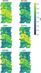
Achieving the Global Climate Observing System goal of 10 m resolution leaf area index (LAI) maps is critical for applications related to climate adaptation, sustainable agriculture, and ecosystem monitoring. Five strategies for producing 10 m LAI maps from Sentinel-2 (S2) imagery are evaluated: i. bi-cubic interpolation of 20 m resolution S2 LAI maps from the Simplified Level 2 Prototype Processor Version 1 (SL2PV1) as currently performed by the Sentinel Applications Platform (SNAP), ii. applying SL2PV1 to S2 reflectance bands spatially downscaled to 10 m using bi-cubic interpolation (BICUBIC), iii. Applying SL2PV1 to S2 reflectance bands spatially downscaled to 10 m using Area to Point Regression Kriging (ATPRK), iv. using a recalibrated version of SL2PV1 (SL2PV2) requiring only three S2 10m bands, and iv) a novel use of the previously developed Active Learning Regularization (ALR) approach to locally approximate the SL2PV1 algorithm using only 10 m bands.
Algorithms were assessed in terms of per-pixel accuracy and spatial metrics when comparing 10 m LAI maps produced using either actual S2 imagery or S2 imagery synthesized from airborne hyperspectral imagery to reference 10 m LAI maps traceable to in-situ fiducial reference measurements at 10 sites across the continental US. ATPRK and ALR algorithms had the lowest precision error of ∼0.15 LAI, compared to 0.19 LAI for SNAP and BICUBIC and 0.35 LAI for SL2PV2, and ranked highest in terms of local correlation and Structural Similarity Index measure as well as qualitative agreement with reference maps. SL2PV2 LAI showed evidence of saturation over forests related to decreased sensitivity of input visible reflectance. All algorithms had a similar uncertainty of ∼0.55 LAI compared to traceable reference maps, due to the trade-off between bias and precision. However, ATPRK and ALR uncertainty reduced to 0.11 LAI and 0.16 LAI, respectively, when compared to reference maps that ignored canopy clumping. These results suggest that both ATPRK and ALR are suitable for producing 10 m S2 LAI maps assuming bias due to local clumping can be corrected in the underlying SL2PV1 algorithm.
期刊介绍:
Remote Sensing of Environment (RSE) serves the Earth observation community by disseminating results on the theory, science, applications, and technology that contribute to advancing the field of remote sensing. With a thoroughly interdisciplinary approach, RSE encompasses terrestrial, oceanic, and atmospheric sensing.
The journal emphasizes biophysical and quantitative approaches to remote sensing at local to global scales, covering a diverse range of applications and techniques.
RSE serves as a vital platform for the exchange of knowledge and advancements in the dynamic field of remote sensing.


 求助内容:
求助内容: 应助结果提醒方式:


