Adam Turnbull, Mariela Soto-Berelov, Michael Coote
{"title":"Delineation and Classification of Wetlands in the Northern Jarrah Forest, Western Australia Using Remote Sensing and Machine Learning","authors":"Adam Turnbull, Mariela Soto-Berelov, Michael Coote","doi":"10.1007/s13157-024-01806-7","DOIUrl":null,"url":null,"abstract":"<p>Wetlands are under increasing pressure from threatening processes. Efforts to protect and monitor wetlands are hampered without datasets capturing the extent, type, and condition. The purpose of this study is to map the distribution of wetland type, vegetation type and vegetation condition for wetlands in the Northern Jarrah Forest region, Western Australia. A random forest algorithm implemented via Google Earth Engine (GEE) was used to classify wetlands and vegetation condition using satellite imagery, topographic indices, and soil mapping. Wetland type was classified using a hierarchical approach incorporating increasing level of detail. Wetland type was mapped as system type from the <i>Interim Australian National Aquatic Ecosystem</i> (ANAE) <i>Classification</i> framework and at hydroperiod level, with overall accuracy of 83% and 82% respectively. Vegetation type was mapped with an accuracy of 78.3%. Mapping of vegetation condition using the <i>Vegetation Assets, States and Transitions</i> (VAST) framework achieved an overall accuracy of 79.6%. Results show that wetlands occur in greater concentration as narrow seasonally waterlogged sites in the west, more sparsely and seasonally inundated sites in the northeast, and as broad seasonally waterlogged sites in the southeast of the study area. Wetland degradation determined through vegetation condition is concentrated in the east, and highest in seasonally waterlogged wetlands. Overall, the wetlands mapping framework implemented in this study can be used by land managers and other interested parties seeking to identify threatened and high conservation value wetlands in other areas.</p>","PeriodicalId":23640,"journal":{"name":"Wetlands","volume":"8 1","pages":""},"PeriodicalIF":2.0000,"publicationDate":"2024-05-01","publicationTypes":"Journal Article","fieldsOfStudy":null,"isOpenAccess":false,"openAccessPdf":"","citationCount":"0","resultStr":null,"platform":"Semanticscholar","paperid":null,"PeriodicalName":"Wetlands","FirstCategoryId":"93","ListUrlMain":"https://doi.org/10.1007/s13157-024-01806-7","RegionNum":4,"RegionCategory":"环境科学与生态学","ArticlePicture":[],"TitleCN":null,"AbstractTextCN":null,"PMCID":null,"EPubDate":"","PubModel":"","JCR":"Q3","JCRName":"ECOLOGY","Score":null,"Total":0}
引用次数: 0
Abstract
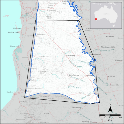
Wetlands are under increasing pressure from threatening processes. Efforts to protect and monitor wetlands are hampered without datasets capturing the extent, type, and condition. The purpose of this study is to map the distribution of wetland type, vegetation type and vegetation condition for wetlands in the Northern Jarrah Forest region, Western Australia. A random forest algorithm implemented via Google Earth Engine (GEE) was used to classify wetlands and vegetation condition using satellite imagery, topographic indices, and soil mapping. Wetland type was classified using a hierarchical approach incorporating increasing level of detail. Wetland type was mapped as system type from the Interim Australian National Aquatic Ecosystem (ANAE) Classification framework and at hydroperiod level, with overall accuracy of 83% and 82% respectively. Vegetation type was mapped with an accuracy of 78.3%. Mapping of vegetation condition using the Vegetation Assets, States and Transitions (VAST) framework achieved an overall accuracy of 79.6%. Results show that wetlands occur in greater concentration as narrow seasonally waterlogged sites in the west, more sparsely and seasonally inundated sites in the northeast, and as broad seasonally waterlogged sites in the southeast of the study area. Wetland degradation determined through vegetation condition is concentrated in the east, and highest in seasonally waterlogged wetlands. Overall, the wetlands mapping framework implemented in this study can be used by land managers and other interested parties seeking to identify threatened and high conservation value wetlands in other areas.
期刊介绍:
Wetlands is an international journal concerned with all aspects of wetlands biology, ecology, hydrology, water chemistry, soil and sediment characteristics, management, and laws and regulations. The journal is published 6 times per year, with the goal of centralizing the publication of pioneering wetlands work that has otherwise been spread among a myriad of journals. Since wetlands research usually requires an interdisciplinary approach, the journal in not limited to specific disciplines but seeks manuscripts reporting research results from all relevant disciplines. Manuscripts focusing on management topics and regulatory considerations relevant to wetlands are also suitable. Submissions may be in the form of articles or short notes. Timely review articles will also be considered, but the subject and content should be discussed with the Editor-in-Chief (NDSU.wetlands.editor@ndsu.edu) prior to submission. All papers published in Wetlands are reviewed by two qualified peers, an Associate Editor, and the Editor-in-Chief prior to acceptance and publication. All papers must present new information, must be factual and original, and must not have been published elsewhere.
 求助内容:
求助内容: 应助结果提醒方式:


