Flavio Marzialetti, Giulia Cesarini, Alicia T. R. Acosta, Corrado Battisti
{"title":"Testing effectiveness in nature reserve management using GIS-based tools: a 25 years monitoring of land use change in a Mediterranean coastal wetland","authors":"Flavio Marzialetti, Giulia Cesarini, Alicia T. R. Acosta, Corrado Battisti","doi":"10.1007/s11273-024-09985-0","DOIUrl":null,"url":null,"abstract":"<p>Land-cover change dynamics were investigated in a Mediterranean coastal wetland to evaluate the long-term effectiveness of nature reserve management. A multitemporal analysis of land cover maps was conducted, utilizing visual interpretation of aerial orthophotos from the summer seasons of 1996, 2008, 2015, and 2021. Landscape changes were evaluated by transition matrices and chord diagrams. Maps were classified in accordance with CORINE land cover types at a fourth level of detail. The multitemporal analyses provided a comprehensive overview of landscape changes within the reserve over the past 25 years. The most notable changes were the increase of wetland areas and the reduction of agricultural and artificial areas. Moreover, seminatural vegetation constantly extended over time. These changes reflected the continuous management activities within the nature reserve, encompassing agreements for water supply, restoration projects, and measures to counteract illegality. These operational actions induced fine-grained ecological changes (outcomes at ecosystem level). This study highlighted the importance of remote sensing and landscape analysis, matched with fine-grained management data, as tool for long-term monitoring. Such an approach provides valuable support in evaluating the effectiveness of strategies promoted in nature reserves hosting wet coastal ecosystems of high conservation concern.</p>","PeriodicalId":49363,"journal":{"name":"Wetlands Ecology and Management","volume":"196 1","pages":""},"PeriodicalIF":1.6000,"publicationDate":"2024-05-01","publicationTypes":"Journal Article","fieldsOfStudy":null,"isOpenAccess":false,"openAccessPdf":"","citationCount":"0","resultStr":null,"platform":"Semanticscholar","paperid":null,"PeriodicalName":"Wetlands Ecology and Management","FirstCategoryId":"93","ListUrlMain":"https://doi.org/10.1007/s11273-024-09985-0","RegionNum":4,"RegionCategory":"环境科学与生态学","ArticlePicture":[],"TitleCN":null,"AbstractTextCN":null,"PMCID":null,"EPubDate":"","PubModel":"","JCR":"Q4","JCRName":"ENVIRONMENTAL SCIENCES","Score":null,"Total":0}
引用次数: 0
Abstract
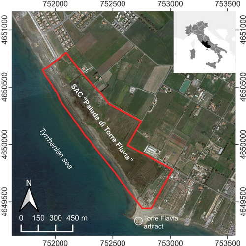
Land-cover change dynamics were investigated in a Mediterranean coastal wetland to evaluate the long-term effectiveness of nature reserve management. A multitemporal analysis of land cover maps was conducted, utilizing visual interpretation of aerial orthophotos from the summer seasons of 1996, 2008, 2015, and 2021. Landscape changes were evaluated by transition matrices and chord diagrams. Maps were classified in accordance with CORINE land cover types at a fourth level of detail. The multitemporal analyses provided a comprehensive overview of landscape changes within the reserve over the past 25 years. The most notable changes were the increase of wetland areas and the reduction of agricultural and artificial areas. Moreover, seminatural vegetation constantly extended over time. These changes reflected the continuous management activities within the nature reserve, encompassing agreements for water supply, restoration projects, and measures to counteract illegality. These operational actions induced fine-grained ecological changes (outcomes at ecosystem level). This study highlighted the importance of remote sensing and landscape analysis, matched with fine-grained management data, as tool for long-term monitoring. Such an approach provides valuable support in evaluating the effectiveness of strategies promoted in nature reserves hosting wet coastal ecosystems of high conservation concern.
期刊介绍:
Wetlands Ecology and Management is an international journal that publishes authoritative and original articles on topics relevant to freshwater, brackish and marine coastal wetland ecosystems. The Journal serves as a multi-disciplinary forum covering key issues in wetlands science, management, policy and economics. As such, Wetlands Ecology and Management aims to encourage the exchange of information between environmental managers, pure and applied scientists, and national and international authorities on wetlands policy and ecological economics.
 求助内容:
求助内容: 应助结果提醒方式:


