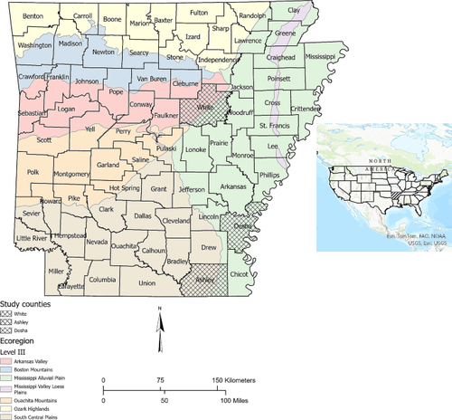
{"title":"Examination of Drone Usage in Estimating Hardwood Plantations Structural Metrics","authors":"Tyler Corbin, Mohammad Bataineh","doi":"10.1007/s13157-024-01807-6","DOIUrl":null,"url":null,"abstract":"<p>Planting hardwood trees on retired marginal agricultural land is one of the main strategies used to restore forested wetlands. Evaluating effectiveness of wetland restoration requires efficient monitoring to evaluate recovery trajectories and desired conditions. Recent advancements in unmanned aerial system (UAS) technologies have prompted wide-scale adoption of UAS platforms in providing a range of ecological data. In this study, we examined the use of UAS Structure from Motion (SfM) derived point clouds in estimating tree density, canopy height, and percent canopy cover for bottomland hardwood plantations within four wetland reserve easements. Using a local maxima approach for individual tree detection produced plantation level estimates with mean absolute errors of 150 trees per hectare, 0.5 m, and 18.4% for tree density, canopy height, and percent canopy cover, respectively. At the plot level, UAS-derived tree counts (<i>r</i> = 0.53, <i>p</i> < 0.01) and canopy height (<i>r</i> = 0.57, <i>p</i> < 0.01) were significantly correlated with ground-based estimates. We demonstrate that UAS-SfM is a viable method of assessing bottomland hardwood plantations for applications that require precision levels congruent with the mean absolute errors reported here. The accuracy of tree density estimates was reliant upon specific local maxima window parameters relative to stand conditions. Therefore, acquisition of leaf-off and leaf-on imagery may allow for better individual tree detection and subsequently more accurate tree density and other structural attributes.</p>","PeriodicalId":23640,"journal":{"name":"Wetlands","volume":"30 1","pages":""},"PeriodicalIF":2.0000,"publicationDate":"2024-04-27","publicationTypes":"Journal Article","fieldsOfStudy":null,"isOpenAccess":false,"openAccessPdf":"","citationCount":"0","resultStr":null,"platform":"Semanticscholar","paperid":null,"PeriodicalName":"Wetlands","FirstCategoryId":"93","ListUrlMain":"https://doi.org/10.1007/s13157-024-01807-6","RegionNum":4,"RegionCategory":"环境科学与生态学","ArticlePicture":[],"TitleCN":null,"AbstractTextCN":null,"PMCID":null,"EPubDate":"","PubModel":"","JCR":"Q3","JCRName":"ECOLOGY","Score":null,"Total":0}
引用次数: 0
Abstract
Planting hardwood trees on retired marginal agricultural land is one of the main strategies used to restore forested wetlands. Evaluating effectiveness of wetland restoration requires efficient monitoring to evaluate recovery trajectories and desired conditions. Recent advancements in unmanned aerial system (UAS) technologies have prompted wide-scale adoption of UAS platforms in providing a range of ecological data. In this study, we examined the use of UAS Structure from Motion (SfM) derived point clouds in estimating tree density, canopy height, and percent canopy cover for bottomland hardwood plantations within four wetland reserve easements. Using a local maxima approach for individual tree detection produced plantation level estimates with mean absolute errors of 150 trees per hectare, 0.5 m, and 18.4% for tree density, canopy height, and percent canopy cover, respectively. At the plot level, UAS-derived tree counts (r = 0.53, p < 0.01) and canopy height (r = 0.57, p < 0.01) were significantly correlated with ground-based estimates. We demonstrate that UAS-SfM is a viable method of assessing bottomland hardwood plantations for applications that require precision levels congruent with the mean absolute errors reported here. The accuracy of tree density estimates was reliant upon specific local maxima window parameters relative to stand conditions. Therefore, acquisition of leaf-off and leaf-on imagery may allow for better individual tree detection and subsequently more accurate tree density and other structural attributes.
期刊介绍:
Wetlands is an international journal concerned with all aspects of wetlands biology, ecology, hydrology, water chemistry, soil and sediment characteristics, management, and laws and regulations. The journal is published 6 times per year, with the goal of centralizing the publication of pioneering wetlands work that has otherwise been spread among a myriad of journals. Since wetlands research usually requires an interdisciplinary approach, the journal in not limited to specific disciplines but seeks manuscripts reporting research results from all relevant disciplines. Manuscripts focusing on management topics and regulatory considerations relevant to wetlands are also suitable. Submissions may be in the form of articles or short notes. Timely review articles will also be considered, but the subject and content should be discussed with the Editor-in-Chief (NDSU.wetlands.editor@ndsu.edu) prior to submission. All papers published in Wetlands are reviewed by two qualified peers, an Associate Editor, and the Editor-in-Chief prior to acceptance and publication. All papers must present new information, must be factual and original, and must not have been published elsewhere.
 求助内容:
求助内容: 应助结果提醒方式:


