Trevor F. Partridge, Zachary C. Johnson, Rachel R. Sleeter, Sharon L. Qi, Michelle A. Walvoord, Sheila F. Murphy, Cara Peterman‐Phipps, Brian A. Ebel
{"title":"Opportunities and challenges for precipitation forcing data in post‐wildfire hydrologic modeling applications","authors":"Trevor F. Partridge, Zachary C. Johnson, Rachel R. Sleeter, Sharon L. Qi, Michelle A. Walvoord, Sheila F. Murphy, Cara Peterman‐Phipps, Brian A. Ebel","doi":"10.1002/wat2.1728","DOIUrl":null,"url":null,"abstract":"The frequency and extent of wildfires have increased in recent decades with immediate and cascading effects on water availability in many regions of the world. Precipitation is used as primary input to hydrologic models and is a critical driver of post‐wildfire hydrologic hazards including debris flows, flash floods, water‐quality effects, and reservoir sedimentation. These models are valuable tools for understanding the hydrologic response to wildfire but require accurate precipitation data at suitable spatial and temporal resolutions. Wildfires often occur in data‐sparse, headwater catchments in complex terrain, and post‐wildfire hydrologic effects are particularly sensitive to high‐intensity, short‐duration precipitation events, which are highly variable and difficult to measure or estimate. Therefore, the assessment and prediction of wildfire‐induced changes to watershed hydrology, including the associated effects on ecosystems and communities, are complicated by uncertainty in precipitation data. When direct measurements of precipitation are not available, datasets of indirect measurements or estimates are often used. Choosing the most appropriate precipitation dataset can be difficult as different datasets have unique trade‐offs in terms of spatial and temporal accuracy, resolution, and completeness. Here, we outline the challenges and opportunities associated with different precipitation datasets as they apply to post‐wildfire hydrologic models and modeling objectives. We highlight the need for expanded precipitation gage deployment in wildfire‐prone areas and discuss potential opportunities for future research and the integration of precipitation data from disparate sources into a common hydrologic modeling framework.This article is categorized under:<jats:list list-type=\"simple\"> <jats:list-item>Science of Water > Hydrological Processes</jats:list-item> <jats:list-item>Science of Water > Methods</jats:list-item> <jats:list-item>Science of Water > Water and Environmental Change</jats:list-item> </jats:list>","PeriodicalId":501223,"journal":{"name":"WIREs Water","volume":"70 1","pages":""},"PeriodicalIF":0.0000,"publicationDate":"2024-04-08","publicationTypes":"Journal Article","fieldsOfStudy":null,"isOpenAccess":false,"openAccessPdf":"","citationCount":"0","resultStr":null,"platform":"Semanticscholar","paperid":null,"PeriodicalName":"WIREs Water","FirstCategoryId":"1085","ListUrlMain":"https://doi.org/10.1002/wat2.1728","RegionNum":0,"RegionCategory":null,"ArticlePicture":[],"TitleCN":null,"AbstractTextCN":null,"PMCID":null,"EPubDate":"","PubModel":"","JCR":"","JCRName":"","Score":null,"Total":0}
引用次数: 0
Abstract
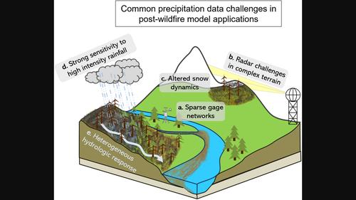
The frequency and extent of wildfires have increased in recent decades with immediate and cascading effects on water availability in many regions of the world. Precipitation is used as primary input to hydrologic models and is a critical driver of post‐wildfire hydrologic hazards including debris flows, flash floods, water‐quality effects, and reservoir sedimentation. These models are valuable tools for understanding the hydrologic response to wildfire but require accurate precipitation data at suitable spatial and temporal resolutions. Wildfires often occur in data‐sparse, headwater catchments in complex terrain, and post‐wildfire hydrologic effects are particularly sensitive to high‐intensity, short‐duration precipitation events, which are highly variable and difficult to measure or estimate. Therefore, the assessment and prediction of wildfire‐induced changes to watershed hydrology, including the associated effects on ecosystems and communities, are complicated by uncertainty in precipitation data. When direct measurements of precipitation are not available, datasets of indirect measurements or estimates are often used. Choosing the most appropriate precipitation dataset can be difficult as different datasets have unique trade‐offs in terms of spatial and temporal accuracy, resolution, and completeness. Here, we outline the challenges and opportunities associated with different precipitation datasets as they apply to post‐wildfire hydrologic models and modeling objectives. We highlight the need for expanded precipitation gage deployment in wildfire‐prone areas and discuss potential opportunities for future research and the integration of precipitation data from disparate sources into a common hydrologic modeling framework.This article is categorized under:Science of Water > Hydrological ProcessesScience of Water > MethodsScience of Water > Water and Environmental Change