{"title":"Coseismic and Tectonic Time-Scale Deformations of an Island Arc Based on the Studies of the East Coast of the Kamchatka Peninsula (Far East, Russia)","authors":"T. K. Pinegina, A. I. Kozhurin","doi":"10.1134/s0016852123060067","DOIUrl":null,"url":null,"abstract":"<h3 data-test=\"abstract-sub-heading\">Abstract</h3><p>The geologic structure of the late Holocene accumulative marine terrace on the Kamchatka Bay coast (Kamchatka Peninsula) has been studied. The obtained age and relative hypsometric position of beach ridges composing the terrace have made it possible to identify two types of vertical coast movements: periodic fast (coseismic) movements and slow time-scale uplift or subsidence. High-amplitude vertical coseismic movements (up to 1‒2 m) occur once every ~1200‒1300 years, on average, while slow movements occur at an average rate of from a fraction of a millimeter to ~2 mm/yr. Coseismic movements as relaxation of elastic deformations accumulated during the interseismic interval of the seismic cycle neither exceed them nor accumulate. Slow movements set the general trend of vertical coast deformations. It is assumed that subsiding central parts of the eastern bays of the Kamchatka Peninsula (Avachinsky, Kronotsky, and Kamchatsky) and depressions between the eastern peninsulas (Kronotsky and Shipunsky) and the main Kamchatka massif form an arc-parallel extension zone located in the closest proximity to the deep-water trench and that the extension is caused by a migration of the subducted part of the Pacific Plate toward the Pacific Ocean. Under the eastern Shipunsky and Kronotsky peninsulas, the arc-normal extension of the earth’s crust of the Kamchatka segment of the Kuril–Kamchatka island arc is replaced by a transverse compression zone.</p>","PeriodicalId":55097,"journal":{"name":"Geotectonics","volume":"99 1","pages":""},"PeriodicalIF":0.8000,"publicationDate":"2024-03-14","publicationTypes":"Journal Article","fieldsOfStudy":null,"isOpenAccess":false,"openAccessPdf":"","citationCount":"0","resultStr":null,"platform":"Semanticscholar","paperid":null,"PeriodicalName":"Geotectonics","FirstCategoryId":"89","ListUrlMain":"https://doi.org/10.1134/s0016852123060067","RegionNum":4,"RegionCategory":"地球科学","ArticlePicture":[],"TitleCN":null,"AbstractTextCN":null,"PMCID":null,"EPubDate":"","PubModel":"","JCR":"Q3","JCRName":"GEOCHEMISTRY & GEOPHYSICS","Score":null,"Total":0}
引用次数: 0
Abstract
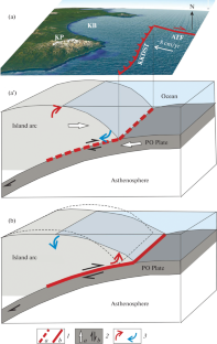
The geologic structure of the late Holocene accumulative marine terrace on the Kamchatka Bay coast (Kamchatka Peninsula) has been studied. The obtained age and relative hypsometric position of beach ridges composing the terrace have made it possible to identify two types of vertical coast movements: periodic fast (coseismic) movements and slow time-scale uplift or subsidence. High-amplitude vertical coseismic movements (up to 1‒2 m) occur once every ~1200‒1300 years, on average, while slow movements occur at an average rate of from a fraction of a millimeter to ~2 mm/yr. Coseismic movements as relaxation of elastic deformations accumulated during the interseismic interval of the seismic cycle neither exceed them nor accumulate. Slow movements set the general trend of vertical coast deformations. It is assumed that subsiding central parts of the eastern bays of the Kamchatka Peninsula (Avachinsky, Kronotsky, and Kamchatsky) and depressions between the eastern peninsulas (Kronotsky and Shipunsky) and the main Kamchatka massif form an arc-parallel extension zone located in the closest proximity to the deep-water trench and that the extension is caused by a migration of the subducted part of the Pacific Plate toward the Pacific Ocean. Under the eastern Shipunsky and Kronotsky peninsulas, the arc-normal extension of the earth’s crust of the Kamchatka segment of the Kuril–Kamchatka island arc is replaced by a transverse compression zone.
期刊介绍:
Geotectonics publishes articles on general and regional tectonics, structural geology, geodynamics, and experimental tectonics and considers the relation of tectonics to the deep structure of the earth, magmatism, metamorphism, and mineral resources.
 求助内容:
求助内容: 应助结果提醒方式:


