A. L. Piskarev, V. D. Kaminsky, A. A. Kireev, V. A. Poselov, V. A. Savin, O. E. Smirnov, D. V. Bezumov, E. A. Dergileva, D. V. Elkina, G. I. Ovanesian, E. S. Ovsiannikova
{"title":"The Structure of the Gakkel Ridge: Geological and Geophysical Data","authors":"A. L. Piskarev, V. D. Kaminsky, A. A. Kireev, V. A. Poselov, V. A. Savin, O. E. Smirnov, D. V. Bezumov, E. A. Dergileva, D. V. Elkina, G. I. Ovanesian, E. S. Ovsiannikova","doi":"10.1134/s0016852123070105","DOIUrl":null,"url":null,"abstract":"<h3 data-test=\"abstract-sub-heading\">Abstract</h3><p>In 2011‒2020 a significant number of seismic lines were carried out in the Eurasian Basin of the Arctic Ocean, which made it possible to study the structure of the junction zones of the Gakkel Ridge with the Nansen and Amundsen basins on a number of profiles. During 2019‒2020 15 sections of the Gakkel Ridge and its rift valley were studied using a sub-bottom profiler and seismo-acoustic profiling. New data on the relief of the basement, as well as the use of databases of bathymetry, gravity, and magnetic anomalies updated at VNIIOkeangeologia, made it possible to calculate the magnetization of the rocks of the Gakkel Ridge along a number of profiles crossing the ridge and to perform model calculations of the structure of the Earth’s crust using a complex of geological and geophysical data in the area of the southeastern termination of the ridge. The Gakkel Ridge is a structure that was isolated in the Early Oligocene (34 Ma)–Early Miocene (23 Ma) in the process of radical restructuring of the spreading kinematics in the existing ocean basins in the regions of the North Atlantic and the Arctic. The values of the calculated magnetization of the magnetic layer of the Earth’s crust show that this layer is partly composed of oceanic basalts, but mainly of deep-originated rocks, gabbro, and peridotites that were brought to the surface during detachment accompanying spreading. The Laptev Sea continuation of the rift valley of the Gakkel Ridge to the south of the caldera passes above many kilometers of sediments, at the base of which sedimentary rocks of Cretaceous and Late Jurassic age occur.</p>","PeriodicalId":55097,"journal":{"name":"Geotectonics","volume":"2015 1","pages":""},"PeriodicalIF":0.8000,"publicationDate":"2024-03-10","publicationTypes":"Journal Article","fieldsOfStudy":null,"isOpenAccess":false,"openAccessPdf":"","citationCount":"0","resultStr":null,"platform":"Semanticscholar","paperid":null,"PeriodicalName":"Geotectonics","FirstCategoryId":"89","ListUrlMain":"https://doi.org/10.1134/s0016852123070105","RegionNum":4,"RegionCategory":"地球科学","ArticlePicture":[],"TitleCN":null,"AbstractTextCN":null,"PMCID":null,"EPubDate":"","PubModel":"","JCR":"Q3","JCRName":"GEOCHEMISTRY & GEOPHYSICS","Score":null,"Total":0}
引用次数: 0
Abstract
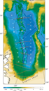
In 2011‒2020 a significant number of seismic lines were carried out in the Eurasian Basin of the Arctic Ocean, which made it possible to study the structure of the junction zones of the Gakkel Ridge with the Nansen and Amundsen basins on a number of profiles. During 2019‒2020 15 sections of the Gakkel Ridge and its rift valley were studied using a sub-bottom profiler and seismo-acoustic profiling. New data on the relief of the basement, as well as the use of databases of bathymetry, gravity, and magnetic anomalies updated at VNIIOkeangeologia, made it possible to calculate the magnetization of the rocks of the Gakkel Ridge along a number of profiles crossing the ridge and to perform model calculations of the structure of the Earth’s crust using a complex of geological and geophysical data in the area of the southeastern termination of the ridge. The Gakkel Ridge is a structure that was isolated in the Early Oligocene (34 Ma)–Early Miocene (23 Ma) in the process of radical restructuring of the spreading kinematics in the existing ocean basins in the regions of the North Atlantic and the Arctic. The values of the calculated magnetization of the magnetic layer of the Earth’s crust show that this layer is partly composed of oceanic basalts, but mainly of deep-originated rocks, gabbro, and peridotites that were brought to the surface during detachment accompanying spreading. The Laptev Sea continuation of the rift valley of the Gakkel Ridge to the south of the caldera passes above many kilometers of sediments, at the base of which sedimentary rocks of Cretaceous and Late Jurassic age occur.
期刊介绍:
Geotectonics publishes articles on general and regional tectonics, structural geology, geodynamics, and experimental tectonics and considers the relation of tectonics to the deep structure of the earth, magmatism, metamorphism, and mineral resources.
 求助内容:
求助内容: 应助结果提醒方式:


