{"title":"Heat Flow at the Eurasian Margin: A Case Study for Estimation of Gas Hydrate Stability","authors":"A. V. Bochkarev, Yu. Yu. Smirnov, T. V. Matveeva","doi":"10.1134/s0016852123070026","DOIUrl":null,"url":null,"abstract":"<h3 data-test=\"abstract-sub-heading\">Abstract</h3><p>Regional-scale geothermal maps are the basis for calculations and mapping of the thermobaric stability zone of submarine gas hydrates. Global geothermal measurements (in particular, at the Eurasian continental margin of the Arctic Ocean) are sporadic. The lack of geotemperature data does not allow mapping of thermal fields using standard interpolation methods. This article presents a solution to this problem and the results of geothermal mapping of the Eurasian continental margin of the Arctic Ocean by extrapolation on a structural-tectonic basis following the age of tectonomagmatic activation of geological structures. The TEMAR-10 000 tectonic map of the Arctic was chosen as a structural-tectonic basis for zoning by age of tectonomagmatic activation. The geothermal studies were based on verified data from the Global Heat Flow Database, as well as published materials and the authors’ original data. A geothermal database consisting of ~1000 geotemperature estimates has been compiled. Verification and statistical analysis of geothermal data in the Eurasian margin of the Arctic Ocean was performed. It has been established that the median values of heat flow are the most applicable for geothermal zoning on a structural-tectonic basis. The geothermal zoning of the Laptev Sea has been clarified based on seismic survey data on the position of the hydrate-related reflector, marking the phase boundary of the gas hydrate stability zone. For the first time, regional-scale geothermal mapping has been carried out at the Eurasian continental margin using actual measured and calculated geothermal data. The compiled geothermal map is the basis for calculating and mapping the gas hydrate stability zone.</p>","PeriodicalId":55097,"journal":{"name":"Geotectonics","volume":"105 1","pages":""},"PeriodicalIF":0.8000,"publicationDate":"2024-03-10","publicationTypes":"Journal Article","fieldsOfStudy":null,"isOpenAccess":false,"openAccessPdf":"","citationCount":"0","resultStr":null,"platform":"Semanticscholar","paperid":null,"PeriodicalName":"Geotectonics","FirstCategoryId":"89","ListUrlMain":"https://doi.org/10.1134/s0016852123070026","RegionNum":4,"RegionCategory":"地球科学","ArticlePicture":[],"TitleCN":null,"AbstractTextCN":null,"PMCID":null,"EPubDate":"","PubModel":"","JCR":"Q3","JCRName":"GEOCHEMISTRY & GEOPHYSICS","Score":null,"Total":0}
引用次数: 0
Abstract
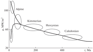
Regional-scale geothermal maps are the basis for calculations and mapping of the thermobaric stability zone of submarine gas hydrates. Global geothermal measurements (in particular, at the Eurasian continental margin of the Arctic Ocean) are sporadic. The lack of geotemperature data does not allow mapping of thermal fields using standard interpolation methods. This article presents a solution to this problem and the results of geothermal mapping of the Eurasian continental margin of the Arctic Ocean by extrapolation on a structural-tectonic basis following the age of tectonomagmatic activation of geological structures. The TEMAR-10 000 tectonic map of the Arctic was chosen as a structural-tectonic basis for zoning by age of tectonomagmatic activation. The geothermal studies were based on verified data from the Global Heat Flow Database, as well as published materials and the authors’ original data. A geothermal database consisting of ~1000 geotemperature estimates has been compiled. Verification and statistical analysis of geothermal data in the Eurasian margin of the Arctic Ocean was performed. It has been established that the median values of heat flow are the most applicable for geothermal zoning on a structural-tectonic basis. The geothermal zoning of the Laptev Sea has been clarified based on seismic survey data on the position of the hydrate-related reflector, marking the phase boundary of the gas hydrate stability zone. For the first time, regional-scale geothermal mapping has been carried out at the Eurasian continental margin using actual measured and calculated geothermal data. The compiled geothermal map is the basis for calculating and mapping the gas hydrate stability zone.
期刊介绍:
Geotectonics publishes articles on general and regional tectonics, structural geology, geodynamics, and experimental tectonics and considers the relation of tectonics to the deep structure of the earth, magmatism, metamorphism, and mineral resources.
 求助内容:
求助内容: 应助结果提醒方式:


