Mohsen Ahmadi, Ahmad Gholizadeh Lonbar, Mohammadsadegh Nouri, Amir Sharifzadeh Javidi, Ali Tarlani Beris, Abbas Sharifi, Ali Salimi-Tarazouj
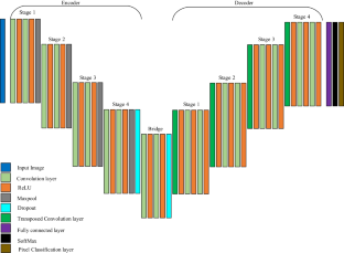
{"title":"Supervised multi-regional segmentation machine learning architecture for digital twin applications in coastal regions","authors":"Mohsen Ahmadi, Ahmad Gholizadeh Lonbar, Mohammadsadegh Nouri, Amir Sharifzadeh Javidi, Ali Tarlani Beris, Abbas Sharifi, Ali Salimi-Tarazouj","doi":"10.1007/s11852-024-01038-1","DOIUrl":null,"url":null,"abstract":"<p>The objective of this study is to develop a global terrain and altitude map by combining a digital twin model and deep learning technique on Florida's coastal area. Utilizing USGS data, we are able to represent diverse landforms while ensuring the accuracy of elevation changes. In order to mitigate projection distortions, we rescaled 5000 map segments worldwide, ensuring that key geographical features are included. We segment the terrain into seven distinct classes: Water, Grassland, Forest, Hills, Desert, Mountain, and Tundra. The map features are enhanced by median filtering and each class is color-coded. Random parameters were introduced in overlapping image sets in order to ensure variety and prevent redundancy. On these seven terrain classes, the U-Net network is used to perform segmentation tasks. In order to monitor the performance of the model, we implemented cross-validation. The model's effectiveness is demonstrated by robust ROC curve analysis and high AUC values, which indicate accurate terrain categorization. Using deep learning methods and satellite imagery from Google Earth, the primary objective is to develop a digital twin of Florida's coastline. The digital twin serves as both a physical and simulation model, accurately resembling real-world locations. In addition to the achievement of detailed terrain mapping, this approach is likely to have significant applications in environmental monitoring and urban planning as well. In terms of reliability and performance, the digital twin model is expected to be a significant advancement in the field of geographical information systems.</p>","PeriodicalId":48909,"journal":{"name":"Journal of Coastal Conservation","volume":"8 1","pages":""},"PeriodicalIF":1.9000,"publicationDate":"2024-03-01","publicationTypes":"Journal Article","fieldsOfStudy":null,"isOpenAccess":false,"openAccessPdf":"","citationCount":"0","resultStr":null,"platform":"Semanticscholar","paperid":null,"PeriodicalName":"Journal of Coastal Conservation","FirstCategoryId":"93","ListUrlMain":"https://doi.org/10.1007/s11852-024-01038-1","RegionNum":4,"RegionCategory":"环境科学与生态学","ArticlePicture":[],"TitleCN":null,"AbstractTextCN":null,"PMCID":null,"EPubDate":"","PubModel":"","JCR":"Q4","JCRName":"ENVIRONMENTAL SCIENCES","Score":null,"Total":0}
引用次数: 0
Abstract
The objective of this study is to develop a global terrain and altitude map by combining a digital twin model and deep learning technique on Florida's coastal area. Utilizing USGS data, we are able to represent diverse landforms while ensuring the accuracy of elevation changes. In order to mitigate projection distortions, we rescaled 5000 map segments worldwide, ensuring that key geographical features are included. We segment the terrain into seven distinct classes: Water, Grassland, Forest, Hills, Desert, Mountain, and Tundra. The map features are enhanced by median filtering and each class is color-coded. Random parameters were introduced in overlapping image sets in order to ensure variety and prevent redundancy. On these seven terrain classes, the U-Net network is used to perform segmentation tasks. In order to monitor the performance of the model, we implemented cross-validation. The model's effectiveness is demonstrated by robust ROC curve analysis and high AUC values, which indicate accurate terrain categorization. Using deep learning methods and satellite imagery from Google Earth, the primary objective is to develop a digital twin of Florida's coastline. The digital twin serves as both a physical and simulation model, accurately resembling real-world locations. In addition to the achievement of detailed terrain mapping, this approach is likely to have significant applications in environmental monitoring and urban planning as well. In terms of reliability and performance, the digital twin model is expected to be a significant advancement in the field of geographical information systems.
期刊介绍:
The Journal of Coastal Conservation is a scientific journal for the dissemination of both theoretical and applied research on integrated and sustainable management of the terrestrial, coastal and marine environmental interface.
A thorough understanding of both the physical and the human sciences is important to the study of the spatial patterns and processes observed in terrestrial, coastal and marine systems set in the context of past, present and future social and economic developments. This includes multidisciplinary and integrated knowledge and understanding of: physical geography, coastal geomorphology, sediment dynamics, hydrodynamics, soil science, hydrology, plant and animal ecology, vegetation science, biogeography, landscape ecology, recreation and tourism studies, urban and human ecology, coastal engineering and spatial planning, coastal zone management, and marine resource management.
 求助内容:
求助内容: 应助结果提醒方式:


