Using photographs and deep neural networks to understand flowering phenology and diversity in mountain meadows
IF 4.3
2区 环境科学与生态学
Q1 ECOLOGY
引用次数: 0
Abstract
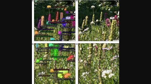
Mountain meadows are an essential part of the alpine–subalpine ecosystem; they provide ecosystem services like pollination and are home to diverse plant communities. Changes in climate affect meadow ecology on multiple levels, for example, by altering growing season dynamics. Tracking the effects of climate change on meadow diversity through the impacts on individual species and overall growing season dynamics is critical to conservation efforts. Here, we explore how to combine crowd-sourced camera images with machine learning to quantify flowering species richness across a range of elevations in alpine meadows located in Mt. Rainier National Park, Washington, USA. We employed three machine-learning techniques (Mask R-CNN, RetinaNet and YOLOv5) to detect wildflower species in images taken during two flowering seasons. We demonstrate that deep learning techniques can detect multiple species, providing information on flowering richness in photographed meadows. The results indicate higher richness just above the tree line for most of the species, which is comparable with patterns found using field studies. We found that the two-stage detector Mask R-CNN was more accurate than single-stage detectors like RetinaNet and YOLO, with the Mask R-CNN network performing best overall with mean average precision (mAP) of 0.67 followed by RetinaNet (0.5) and YOLO (0.4). We found that across the methods using anchor box variations in multiples of 16 led to enhanced accuracy. We also show that detection is possible even when pictures are interspersed with complex backgrounds and are not in focus. We found differential detection rates depending on species abundance, with additional challenges related to similarity in flower characteristics, labeling errors and occlusion issues. Despite these potential biases and limitations in capturing flowering abundance and location-specific quantification, accuracy was notable considering the complexity of flower types and picture angles in this dataset. We, therefore, expect that this approach can be used to address many ecological questions that benefit from automated flower detection, including studies of flowering phenology and floral resources, and that this approach can, therefore, complement a wide range of ecological approaches (e.g., field observations, experiments, community science, etc.). In all, our study suggests that ecological metrics like floral richness can be efficiently monitored by combining machine learning with easily accessible publicly curated datasets (e.g., Flickr, iNaturalist).

利用照片和深度神经网络了解高山草甸的开花物候和多样性
高山草甸是高山-亚高山生态系统的重要组成部分;它们提供授粉等生态系统服务,是多种植物群落的家园。气候变化会在多个层面上影响草甸生态,例如改变生长季节的动态变化。通过对单个物种和整体生长季动态的影响来跟踪气候变化对草甸多样性的影响,对保护工作至关重要。在此,我们探讨了如何将众包相机图像与机器学习相结合,以量化美国华盛顿州雷尼尔山国家公园高山草甸不同海拔地区的开花物种丰富度。我们采用了三种机器学习技术(Mask R-CNN、RetinaNet 和 YOLOv5)来检测两个花季拍摄的图像中的野花物种。我们证明了深度学习技术可以检测出多个物种,从而提供所拍摄草地的花卉丰富度信息。结果表明,大多数物种在树线上方的丰富度较高,这与实地研究发现的模式不相上下。我们发现,两阶段检测器 Mask R-CNN 比 RetinaNet 和 YOLO 等单阶段检测器更准确,其中 Mask R-CNN 网络的总体表现最好,平均精度 (mAP) 为 0.67,其次是 RetinaNet(0.5)和 YOLO(0.4)。我们发现,在所有方法中,使用 16 倍的锚框变化可提高精确度。我们还表明,即使图片中夹杂着复杂的背景,并且没有对焦,也能进行检测。我们发现,不同物种的丰度会导致不同的检测率,此外,花朵特征的相似性、标签错误和遮挡问题也会带来额外的挑战。尽管在捕捉花卉丰度和特定地点量化方面存在这些潜在的偏差和局限性,但考虑到该数据集中花卉类型和图片角度的复杂性,准确率还是很高的。因此,我们预计这种方法可用于解决许多受益于自动花卉检测的生态学问题,包括花卉物候学和花卉资源的研究,因此这种方法可作为多种生态学方法(如实地观察、实验、群落科学等)的补充。总之,我们的研究表明,通过将机器学习与易于获取的公开数据集(如 Flickr、iNaturalist)相结合,可以有效地监测花卉丰富度等生态指标。
本文章由计算机程序翻译,如有差异,请以英文原文为准。
求助全文
约1分钟内获得全文
求助全文
来源期刊

Remote Sensing in Ecology and Conservation
Earth and Planetary Sciences-Computers in Earth Sciences
CiteScore
9.80
自引率
5.50%
发文量
69
审稿时长
18 weeks
期刊介绍:
emote Sensing in Ecology and Conservation provides a forum for rapid, peer-reviewed publication of novel, multidisciplinary research at the interface between remote sensing science and ecology and conservation. The journal prioritizes findings that advance the scientific basis of ecology and conservation, promoting the development of remote-sensing based methods relevant to the management of land use and biological systems at all levels, from populations and species to ecosystems and biomes. The journal defines remote sensing in its broadest sense, including data acquisition by hand-held and fixed ground-based sensors, such as camera traps and acoustic recorders, and sensors on airplanes and satellites. The intended journal’s audience includes ecologists, conservation scientists, policy makers, managers of terrestrial and aquatic systems, remote sensing scientists, and students.
Remote Sensing in Ecology and Conservation is a fully open access journal from Wiley and the Zoological Society of London. Remote sensing has enormous potential as to provide information on the state of, and pressures on, biological diversity and ecosystem services, at multiple spatial and temporal scales. This new publication provides a forum for multidisciplinary research in remote sensing science, ecological research and conservation science.
 求助内容:
求助内容: 应助结果提醒方式:


