Miguel Vallejo Orti , Katharina Anders , Oluibukun Ajayi , Olaf Bubenzer , Bernhard Höfle
{"title":"Integrating multi-user digitising actions for mapping gully outlines using a combined approach of Kalman filtering and machine learning","authors":"Miguel Vallejo Orti , Katharina Anders , Oluibukun Ajayi , Olaf Bubenzer , Bernhard Höfle","doi":"10.1016/j.ophoto.2024.100059","DOIUrl":null,"url":null,"abstract":"<div><p>Scalable and transferable methods for generating reliable reference data for automated remote sensing approaches are crucial, especially for mapping complex Earth surface processes such as gully erosion in low-populated and inaccessible areas. As an alternative for the labour-intense in-situ authoritative mapping, collaborative approaches enable volunteers to generate redundant independent geoinformation by digitising Earth observation imagery. We face the challenge of mapping the complex gully outlines integrating multi-user contributions of the same gully network. Comparing Sentinel 2, Bing Aerial, and unoccupied aerial vehicle orthophoto base maps, we examine the volunteered geographic information process and multi-contribution integration using Kalman filtering and machine learning to segment a gully border in a remote area in northwestern Namibia. The Kalman filtering integrates the different lines finding a smoothed solution, and a Random Forest model is used to identify mapping conditions and terrain features as key predictors for evaluating contributors' digitising quality. Assessing results with expert-based reference data, we identify ten contributions as optimal, yielding root mean square distance values of 19.1 m, 15.9 m and 16.6 m, and variability of 2.0 m, 4.2 m and 3.8 m (root mean square distance standard deviation) for Sentinel 2, Bing Aerial, and unoccupied aerial vehicle orthophoto, respectively. Eliminating the lowest performing contributions for Sentinel 2 using a Random Forest regression-based quality indicator improves the accuracy by up to 35% in the root mean square distance compared to a random selection, and up to 54% compared to a supervised remote sensing classification. Results for Sentinel 2 show that low slope, low terrain ruggedness index, and high normalised difference vegetation index values are correlated to high spatial mapping deviations, with Pearson correlation coefficients of −0.61, −0.5, and 0.18, respectively. Our approach is a powerful alternative for authoritative mapping of morphologically complex environmental phenomena and can provide independent reference data for supervised automatic remote sensing analysis.</p></div>","PeriodicalId":100730,"journal":{"name":"ISPRS Open Journal of Photogrammetry and Remote Sensing","volume":"12 ","pages":"Article 100059"},"PeriodicalIF":0.0000,"publicationDate":"2024-02-10","publicationTypes":"Journal Article","fieldsOfStudy":null,"isOpenAccess":false,"openAccessPdf":"https://www.sciencedirect.com/science/article/pii/S2667393224000024/pdfft?md5=48a1afef19ee80fc26305409481984b5&pid=1-s2.0-S2667393224000024-main.pdf","citationCount":"0","resultStr":null,"platform":"Semanticscholar","paperid":null,"PeriodicalName":"ISPRS Open Journal of Photogrammetry and Remote Sensing","FirstCategoryId":"1085","ListUrlMain":"https://www.sciencedirect.com/science/article/pii/S2667393224000024","RegionNum":0,"RegionCategory":null,"ArticlePicture":[],"TitleCN":null,"AbstractTextCN":null,"PMCID":null,"EPubDate":"","PubModel":"","JCR":"","JCRName":"","Score":null,"Total":0}
引用次数: 0
Abstract
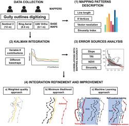
Scalable and transferable methods for generating reliable reference data for automated remote sensing approaches are crucial, especially for mapping complex Earth surface processes such as gully erosion in low-populated and inaccessible areas. As an alternative for the labour-intense in-situ authoritative mapping, collaborative approaches enable volunteers to generate redundant independent geoinformation by digitising Earth observation imagery. We face the challenge of mapping the complex gully outlines integrating multi-user contributions of the same gully network. Comparing Sentinel 2, Bing Aerial, and unoccupied aerial vehicle orthophoto base maps, we examine the volunteered geographic information process and multi-contribution integration using Kalman filtering and machine learning to segment a gully border in a remote area in northwestern Namibia. The Kalman filtering integrates the different lines finding a smoothed solution, and a Random Forest model is used to identify mapping conditions and terrain features as key predictors for evaluating contributors' digitising quality. Assessing results with expert-based reference data, we identify ten contributions as optimal, yielding root mean square distance values of 19.1 m, 15.9 m and 16.6 m, and variability of 2.0 m, 4.2 m and 3.8 m (root mean square distance standard deviation) for Sentinel 2, Bing Aerial, and unoccupied aerial vehicle orthophoto, respectively. Eliminating the lowest performing contributions for Sentinel 2 using a Random Forest regression-based quality indicator improves the accuracy by up to 35% in the root mean square distance compared to a random selection, and up to 54% compared to a supervised remote sensing classification. Results for Sentinel 2 show that low slope, low terrain ruggedness index, and high normalised difference vegetation index values are correlated to high spatial mapping deviations, with Pearson correlation coefficients of −0.61, −0.5, and 0.18, respectively. Our approach is a powerful alternative for authoritative mapping of morphologically complex environmental phenomena and can provide independent reference data for supervised automatic remote sensing analysis.

 求助内容:
求助内容: 应助结果提醒方式:


