{"title":"A radar image seabird identification method for analyzing the effects of FADs on seabirds","authors":"Qinglian Hou, Rong Wan, Cheng Zhou","doi":"10.1007/s12562-024-01749-2","DOIUrl":null,"url":null,"abstract":"<p>In the tuna purse seine fishery, seiners spend a considerable amount of time detecting objects such as seabirds, for which radar is a very efficient method. In this study, we present a radar image seabird identification method that can calculate the number of clusters, the area of seabird clusters, and the activity level of seabird clusters. We used a fishing vessel’s radar to collect information on seabird groups within 29,632 km of the vessel and calculated a spatial clustering of the seabird-echoes. Generalized additive mixed models (GAMM) were used to investigate the relationship between drifting fish aggregating devices (FADs) and seabird dynamics in the Republic of Kiribati. The findings indicate that FAD variables affected seabird behavior. The random effects on cluster number, cluster area, and cluster ability were 3.27, 17.41, and −0.17, respectively. Then, we compared the radar image information that was calculated. The bird cluster around drifting FADs was found to be more concentrated and denser than in areas without FADs, with a lower level of activity observed. The longitude of 165°E had the highest number of bird clusters and the greatest area inhabited by birds, but these decreased to the east. However, model 3 showed that the minimum value of seabird cluster activity level occurred around 165°E and increased to the east.</p>","PeriodicalId":12231,"journal":{"name":"Fisheries Science","volume":"324 1","pages":""},"PeriodicalIF":1.4000,"publicationDate":"2024-02-12","publicationTypes":"Journal Article","fieldsOfStudy":null,"isOpenAccess":false,"openAccessPdf":"","citationCount":"0","resultStr":null,"platform":"Semanticscholar","paperid":null,"PeriodicalName":"Fisheries Science","FirstCategoryId":"97","ListUrlMain":"https://doi.org/10.1007/s12562-024-01749-2","RegionNum":4,"RegionCategory":"农林科学","ArticlePicture":[],"TitleCN":null,"AbstractTextCN":null,"PMCID":null,"EPubDate":"","PubModel":"","JCR":"Q3","JCRName":"FISHERIES","Score":null,"Total":0}
引用次数: 0
Abstract
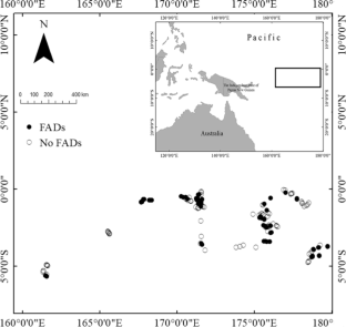
In the tuna purse seine fishery, seiners spend a considerable amount of time detecting objects such as seabirds, for which radar is a very efficient method. In this study, we present a radar image seabird identification method that can calculate the number of clusters, the area of seabird clusters, and the activity level of seabird clusters. We used a fishing vessel’s radar to collect information on seabird groups within 29,632 km of the vessel and calculated a spatial clustering of the seabird-echoes. Generalized additive mixed models (GAMM) were used to investigate the relationship between drifting fish aggregating devices (FADs) and seabird dynamics in the Republic of Kiribati. The findings indicate that FAD variables affected seabird behavior. The random effects on cluster number, cluster area, and cluster ability were 3.27, 17.41, and −0.17, respectively. Then, we compared the radar image information that was calculated. The bird cluster around drifting FADs was found to be more concentrated and denser than in areas without FADs, with a lower level of activity observed. The longitude of 165°E had the highest number of bird clusters and the greatest area inhabited by birds, but these decreased to the east. However, model 3 showed that the minimum value of seabird cluster activity level occurred around 165°E and increased to the east.
期刊介绍:
Fisheries Science is the official journal of the Japanese Society of Fisheries Science, which was established in 1932. Recognized as a leading journal in its field, Fisheries Science is respected internationally for the publication of basic and applied research articles in a broad range of subject areas relevant to fisheries science. All articles are peer-reviewed by at least two experts in the field of the submitted paper. Published six times per year, Fisheries Science includes about 120 articles per volume. It has a rich history of publishing quality papers in fisheries, biology, aquaculture, environment, chemistry and biochemistry, food science and technology, and Social Science.
 求助内容:
求助内容: 应助结果提醒方式:


