The emergence of urban heat traps and human mobility in 20 US cities

IF 9.1 Q1 ENVIRONMENTAL STUDIES
Xinke Huang, Yuqin Jiang, Ali Mostafavi
{"title":"The emergence of urban heat traps and human mobility in 20 US cities","authors":"Xinke Huang, Yuqin Jiang, Ali Mostafavi","doi":"10.1038/s42949-024-00142-3","DOIUrl":null,"url":null,"abstract":"Understanding the relationship between spatial structures of cities and environmental hazard exposures is essential for urban health and sustainability planning. However, a critical knowledge gap exists in terms of the extent to which socio-spatial networks shaped by human mobility exacerbate or alleviate urban heat exposures of populations in cities. In this study, we utilize location-based data to construct human mobility networks in twenty metropolitan areas in the U.S. The human mobility networks are analyzed in conjunction with the urban heat characteristics of spatial areas. We identify areas with high and low urban heat exposure and evaluate visitation patterns of populations residing in high and low urban heat areas to other spatial areas with similar and dissimilar urban heat exposure. The results reveal the presence of urban heat traps in the majority of the studied metropolitan areas, wherein populations residing in high-heat exposure areas primarily visited other high-heat exposure zones. Specifically, cities such as Los Angeles, Boston, and Chicago were particularly pronounced as urban heat traps. The results also show a small percentage of human mobility to produce urban heat escalation and heat escapes. The findings from this study provide a better understanding of urban heat exposure in cities based on patterns of human mobility. These findings contribute to a broader understanding of the intersection of human network dynamics and environmental hazard exposures in cities to inform more integrated urban design and planning to promote health and sustainability.","PeriodicalId":74322,"journal":{"name":"npj urban sustainability","volume":" ","pages":"1-13"},"PeriodicalIF":9.1000,"publicationDate":"2024-02-01","publicationTypes":"Journal Article","fieldsOfStudy":null,"isOpenAccess":false,"openAccessPdf":"https://www.nature.com/articles/s42949-024-00142-3.pdf","citationCount":"0","resultStr":null,"platform":"Semanticscholar","paperid":null,"PeriodicalName":"npj urban sustainability","FirstCategoryId":"1085","ListUrlMain":"https://www.nature.com/articles/s42949-024-00142-3","RegionNum":0,"RegionCategory":null,"ArticlePicture":[],"TitleCN":null,"AbstractTextCN":null,"PMCID":null,"EPubDate":"","PubModel":"","JCR":"Q1","JCRName":"ENVIRONMENTAL STUDIES","Score":null,"Total":0}
引用次数: 0

Abstract

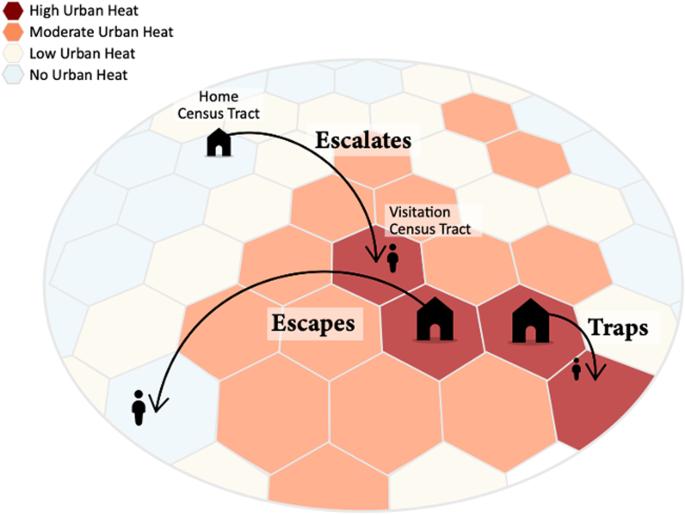
Understanding the relationship between spatial structures of cities and environmental hazard exposures is essential for urban health and sustainability planning. However, a critical knowledge gap exists in terms of the extent to which socio-spatial networks shaped by human mobility exacerbate or alleviate urban heat exposures of populations in cities. In this study, we utilize location-based data to construct human mobility networks in twenty metropolitan areas in the U.S. The human mobility networks are analyzed in conjunction with the urban heat characteristics of spatial areas. We identify areas with high and low urban heat exposure and evaluate visitation patterns of populations residing in high and low urban heat areas to other spatial areas with similar and dissimilar urban heat exposure. The results reveal the presence of urban heat traps in the majority of the studied metropolitan areas, wherein populations residing in high-heat exposure areas primarily visited other high-heat exposure zones. Specifically, cities such as Los Angeles, Boston, and Chicago were particularly pronounced as urban heat traps. The results also show a small percentage of human mobility to produce urban heat escalation and heat escapes. The findings from this study provide a better understanding of urban heat exposure in cities based on patterns of human mobility. These findings contribute to a broader understanding of the intersection of human network dynamics and environmental hazard exposures in cities to inform more integrated urban design and planning to promote health and sustainability.
Abstract Image

美国 20 个城市出现的城市热阱与人类流动性
了解城市空间结构与环境危害暴露之间的关系对于城市健康和可持续性规划至关重要。然而,在人类流动所形成的社会空间网络在多大程度上加剧或减轻城市人口的城市热暴露方面,还存在着重要的知识空白。在本研究中,我们利用基于位置的数据构建了美国 20 个大都市地区的人类流动网络。我们确定了城市热暴露程度较高和较低的地区,并评估了居住在城市热暴露程度较高和较低地区的人口对城市热暴露程度相似和相似的其他空间区域的访问模式。研究结果表明,在所研究的大多数大都市地区都存在城市热量陷阱,即居住在高热量暴露区的人口主要访问其他高热量暴露区。具体而言,洛杉矶、波士顿和芝加哥等城市的城市热阱现象尤为明显。研究结果还显示,人类的小部分流动造成了城市热量升级和热量逃逸。这项研究的结果使人们更好地了解了基于人类流动模式的城市热暴露。这些发现有助于人们更广泛地了解城市中人类网络动态与环境危害暴露之间的交叉关系,从而为更加综合的城市设计和规划提供信息,以促进健康和可持续发展。
本文章由计算机程序翻译,如有差异,请以英文原文为准。
求助全文
约1分钟内获得全文 求助全文
来源期刊
CiteScore
10.00
自引率
0.00%
发文量
0
×
引用
GB/T 7714-2015
复制
MLA
复制
APA
复制
导出至
BibTeX EndNote RefMan NoteFirst NoteExpress
×
提示
您的信息不完整,为了账户安全,请先补充。
现在去补充
×
提示
您因"违规操作"
具体请查看互助需知
我知道了
×
提示
确定
请完成安全验证×
copy
已复制链接
快去分享给好友吧!
我知道了
右上角分享
点击右上角分享
0
联系我们:info@booksci.cn Book学术提供免费学术资源搜索服务,方便国内外学者检索中英文文献。致力于提供最便捷和优质的服务体验。 Copyright © 2023 布克学术 All rights reserved.
京ICP备2023020795号-1
ghs 京公网安备 11010802042870号
Book学术文献互助
Book学术文献互助群
群 号:481959085
Book学术官方微信