{"title":"Water quality index, risk assessment in a coastal aquifer: the Djendjen aquifer (Jijel, Algeria)","authors":"Badra Attoui, Lamine Sayad, Habiba Majour, Khaled Harizi, Nadjib Drouiche, Hamza Bouguerra","doi":"10.1007/s11852-024-01031-8","DOIUrl":null,"url":null,"abstract":"<p>Preserving the quality of water resources requires researching and identifying areas susceptible to potential aquifer contamination. Therefore, the protection of these resources is paramount. This work falls within this thematic area. The main objective of this study is to identify areas at potential risk of marine intrusion and assess the Water Quality Index (WQI) in the Djedjen plain. To achieve this goal, our choice was to combine the GALDIT model based on six criteria and the Water Quality Index (WQI) based on seven parameters (Na<sup>+</sup>, Mg<sup>2+</sup>, Ca<sup>2+</sup>, SO<sub>4</sub><sup>2−</sup>, Cl<sup>−</sup>, HCO<sub>3</sub><sup>−</sup>, and EC). We utilized Geographic Information System (GIS) for this purpose. The analytical results have shown that 11% of the study area's surface is at potential risk of contamination, linked both to marine intrusion and various anthropogenic activities. Therefore, continuous monitoring of the water quality in this area is necessary.</p>","PeriodicalId":48909,"journal":{"name":"Journal of Coastal Conservation","volume":"9 1","pages":""},"PeriodicalIF":1.9000,"publicationDate":"2024-02-01","publicationTypes":"Journal Article","fieldsOfStudy":null,"isOpenAccess":false,"openAccessPdf":"","citationCount":"0","resultStr":null,"platform":"Semanticscholar","paperid":null,"PeriodicalName":"Journal of Coastal Conservation","FirstCategoryId":"93","ListUrlMain":"https://doi.org/10.1007/s11852-024-01031-8","RegionNum":4,"RegionCategory":"环境科学与生态学","ArticlePicture":[],"TitleCN":null,"AbstractTextCN":null,"PMCID":null,"EPubDate":"","PubModel":"","JCR":"Q4","JCRName":"ENVIRONMENTAL SCIENCES","Score":null,"Total":0}
引用次数: 0
Abstract
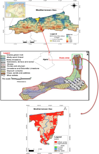
Preserving the quality of water resources requires researching and identifying areas susceptible to potential aquifer contamination. Therefore, the protection of these resources is paramount. This work falls within this thematic area. The main objective of this study is to identify areas at potential risk of marine intrusion and assess the Water Quality Index (WQI) in the Djedjen plain. To achieve this goal, our choice was to combine the GALDIT model based on six criteria and the Water Quality Index (WQI) based on seven parameters (Na+, Mg2+, Ca2+, SO42−, Cl−, HCO3−, and EC). We utilized Geographic Information System (GIS) for this purpose. The analytical results have shown that 11% of the study area's surface is at potential risk of contamination, linked both to marine intrusion and various anthropogenic activities. Therefore, continuous monitoring of the water quality in this area is necessary.
期刊介绍:
The Journal of Coastal Conservation is a scientific journal for the dissemination of both theoretical and applied research on integrated and sustainable management of the terrestrial, coastal and marine environmental interface.
A thorough understanding of both the physical and the human sciences is important to the study of the spatial patterns and processes observed in terrestrial, coastal and marine systems set in the context of past, present and future social and economic developments. This includes multidisciplinary and integrated knowledge and understanding of: physical geography, coastal geomorphology, sediment dynamics, hydrodynamics, soil science, hydrology, plant and animal ecology, vegetation science, biogeography, landscape ecology, recreation and tourism studies, urban and human ecology, coastal engineering and spatial planning, coastal zone management, and marine resource management.
 求助内容:
求助内容: 应助结果提醒方式:


