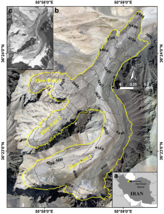
Examining Multidecadal Variations in Glacier Surface Temperature at Debris-Covered Alamkouh Glacier in Iran (1985–2020) Using the Landsat Surface Temperature Product
IF 2.1 4区 地球科学Q3 IMAGING SCIENCE & PHOTOGRAPHIC TECHNOLOGY
Neamat Karimi, Omid Torabi, Amirhossein Sarbazvatan, Sara Sheshangosht
{"title":"Examining Multidecadal Variations in Glacier Surface Temperature at Debris-Covered Alamkouh Glacier in Iran (1985–2020) Using the Landsat Surface Temperature Product","authors":"Neamat Karimi, Omid Torabi, Amirhossein Sarbazvatan, Sara Sheshangosht","doi":"10.1007/s41064-023-00270-y","DOIUrl":null,"url":null,"abstract":"<p>This study aimed to assess the temporal changes in glacier surface temperature (GST) for the debris-covered Alamkouh glacier (over 88% of the total glacier area is debris covered), located in Iran, over the period from 1985 to 2020. The analysis employed the Landsat surface temperature product at a spatial resolution of 30 m. The research pursued three primary objectives: (1) a spatiotemporal analysis of GST changes, (2) an evaluation of correlations between GST and glacier variables such as ice-thickness change and albedo, and (3) the identification of factors influencing GST, including air temperature, cloud cover, precipitation, and snowfall, utilizing the Global Land Data Assimilation System dataset. Spatial changes were analyzed using the Mann–Kendall trend test and Sen’s slope estimator, revealing statistically significant positive or negative trends in all multitemporal parameters. The spatial change analysis showed that GST increased between 0 and +0.2 °C/a from 1985 to 2020. The mean annual GST increase for the entire glacier is 0.086 °C/a, signifying a 3 °C rise over 36 years. High-altitude regions exhibit more substantial GST increases than lower-altitude areas do, although a discernible pattern across the glacier’s surface remains elusive. To complement the spatial GST analysis, we divided the study period into four periods, 1985–1990, 1990–2000, 2000–2010, and 2010–2020, and mean GST was calculated separately for ablation months. Results indicate stability in mean GST from 1985–1990 to 1990–2000, followed by a significant increase of 2.3 °C/decade from 1990–2000 to 2000–2010, representing the largest increase observed. Temporal change analysis over 36 years reveals that the most significant warming occurs in debris-covered areas (0.139 °C/a), with less warming observed in debris-free regions (0.097 °C/a) during both accumulation and ablation months. The study employed the normalized difference snow index to identify debris-free areas and assess their potential impact on GST. First, the results establish a robust inverse relationship between GST and the extent of debris-free terrain. Second, the analysis demonstrates a significant reduction in debris-free terrain at a rate of −0.035% per month since 1985, culminating in a 15.12% decline over 36 years, encompassing both accumulation and ablation periods. Additionally, outcomes from the albedo analysis reveal a robust negative correlation between albedo and mean GST, with an R<sup>2</sup> of 0.57. The examination of albedo alterations shows a substantial annual decrease of approximately −0.08/a across the entirety of the glacier terrain, while albedo remains stable in low-elevation areas over the 36-year period, with significant changes occurring in high-elevation debris-free regions. In contrast, a comprehensive examination reveals that a robust association between the glacier ice-thinning rate and GST change cannot be ascertained. Among climate variables, air temperature exhibits significant warming, increasing at a rate of 0.016 °C/a from 1985 to 2020, while other variables remain stable. Understanding these multifaceted influences on glacier surface temperature is vital for adapting to ongoing climate changes in glacial regions. Further research is needed to disentangle intricate interactions among climate parameters and their cumulative effects on glacier dynamics.</p>","PeriodicalId":56035,"journal":{"name":"PFG-Journal of Photogrammetry Remote Sensing and Geoinformation Science","volume":"142 1","pages":""},"PeriodicalIF":2.1000,"publicationDate":"2024-01-29","publicationTypes":"Journal Article","fieldsOfStudy":null,"isOpenAccess":false,"openAccessPdf":"","citationCount":"0","resultStr":null,"platform":"Semanticscholar","paperid":null,"PeriodicalName":"PFG-Journal of Photogrammetry Remote Sensing and Geoinformation Science","FirstCategoryId":"89","ListUrlMain":"https://doi.org/10.1007/s41064-023-00270-y","RegionNum":4,"RegionCategory":"地球科学","ArticlePicture":[],"TitleCN":null,"AbstractTextCN":null,"PMCID":null,"EPubDate":"","PubModel":"","JCR":"Q3","JCRName":"IMAGING SCIENCE & PHOTOGRAPHIC TECHNOLOGY","Score":null,"Total":0}
引用次数: 0
Abstract
This study aimed to assess the temporal changes in glacier surface temperature (GST) for the debris-covered Alamkouh glacier (over 88% of the total glacier area is debris covered), located in Iran, over the period from 1985 to 2020. The analysis employed the Landsat surface temperature product at a spatial resolution of 30 m. The research pursued three primary objectives: (1) a spatiotemporal analysis of GST changes, (2) an evaluation of correlations between GST and glacier variables such as ice-thickness change and albedo, and (3) the identification of factors influencing GST, including air temperature, cloud cover, precipitation, and snowfall, utilizing the Global Land Data Assimilation System dataset. Spatial changes were analyzed using the Mann–Kendall trend test and Sen’s slope estimator, revealing statistically significant positive or negative trends in all multitemporal parameters. The spatial change analysis showed that GST increased between 0 and +0.2 °C/a from 1985 to 2020. The mean annual GST increase for the entire glacier is 0.086 °C/a, signifying a 3 °C rise over 36 years. High-altitude regions exhibit more substantial GST increases than lower-altitude areas do, although a discernible pattern across the glacier’s surface remains elusive. To complement the spatial GST analysis, we divided the study period into four periods, 1985–1990, 1990–2000, 2000–2010, and 2010–2020, and mean GST was calculated separately for ablation months. Results indicate stability in mean GST from 1985–1990 to 1990–2000, followed by a significant increase of 2.3 °C/decade from 1990–2000 to 2000–2010, representing the largest increase observed. Temporal change analysis over 36 years reveals that the most significant warming occurs in debris-covered areas (0.139 °C/a), with less warming observed in debris-free regions (0.097 °C/a) during both accumulation and ablation months. The study employed the normalized difference snow index to identify debris-free areas and assess their potential impact on GST. First, the results establish a robust inverse relationship between GST and the extent of debris-free terrain. Second, the analysis demonstrates a significant reduction in debris-free terrain at a rate of −0.035% per month since 1985, culminating in a 15.12% decline over 36 years, encompassing both accumulation and ablation periods. Additionally, outcomes from the albedo analysis reveal a robust negative correlation between albedo and mean GST, with an R2 of 0.57. The examination of albedo alterations shows a substantial annual decrease of approximately −0.08/a across the entirety of the glacier terrain, while albedo remains stable in low-elevation areas over the 36-year period, with significant changes occurring in high-elevation debris-free regions. In contrast, a comprehensive examination reveals that a robust association between the glacier ice-thinning rate and GST change cannot be ascertained. Among climate variables, air temperature exhibits significant warming, increasing at a rate of 0.016 °C/a from 1985 to 2020, while other variables remain stable. Understanding these multifaceted influences on glacier surface temperature is vital for adapting to ongoing climate changes in glacial regions. Further research is needed to disentangle intricate interactions among climate parameters and their cumulative effects on glacier dynamics.
期刊介绍:
PFG is an international scholarly journal covering the progress and application of photogrammetric methods, remote sensing technology and the interconnected field of geoinformation science. It places special editorial emphasis on the communication of new methodologies in data acquisition and new approaches to optimized processing and interpretation of all types of data which were acquired by photogrammetric methods, remote sensing, image processing and the computer-aided interpretation of such data in general. The journal hence addresses both researchers and students of these disciplines at academic institutions and universities as well as the downstream users in both the private sector and public administration.
Founded in 1926 under the former name Bildmessung und Luftbildwesen, PFG is worldwide the oldest journal on photogrammetry. It is the official journal of the German Society for Photogrammetry, Remote Sensing and Geoinformation (DGPF).
 求助内容:
求助内容: 应助结果提醒方式:


