Idawarni Asmal, Edward Syarif, Samsuddin Amin, M. Yahya Siradjuddin, Sapta Asmal, Fridawaty Rivai, Rudi Latief, Ridwan
{"title":"Human external and internal activities in the destruction of the north galesong coastal area","authors":"Idawarni Asmal, Edward Syarif, Samsuddin Amin, M. Yahya Siradjuddin, Sapta Asmal, Fridawaty Rivai, Rudi Latief, Ridwan","doi":"10.1007/s11852-023-01026-x","DOIUrl":null,"url":null,"abstract":"<p>The research aims to find out what part of human activities on the outside and inside played in the destruction of the coastal area; in this case, it examines human activities carried out by residents and sand mining entrepreneurs around the north Galesong Sea, which have an impact on change structure of land use and abrasion of coastal areas—using a quantitative paradigm with quantitative methods as the primary method and qualitative as support. The quantitative method uses a geographic approach, namely a spatial approach using a Geographic Information System in its analysis. GIS uses spatially based data, namely geographically oriented data. Data used in this study are land use maps and village shorelines. The qualitative method used descriptive case studies. Qualitative data: The population of this study is Aeng Batu village. There are two types of research samples, namely area and human samples; area samples are taken from the description of conditions when abrasion occurs and after post-abrasion repairs occur. For the human sample, the respondents were community leaders, village officials, and the community to find out the purpose of digging beach sand and dumping trash on the beach in ex-dug holes. The data is described and supplemented with photographs of actual conditions in the field—analysis techniques using analytical descriptions. In conclusion, damage to coastal land caused by human activities does not only come from mining at sea but also the activities of residents who use beach land and beach sand (for residential construction and garbage disposal), the physical shape of the beach, the damage is exacerbated by high rainfall, wind, and waves, especially during the rainy season.</p>","PeriodicalId":48909,"journal":{"name":"Journal of Coastal Conservation","volume":"15 1","pages":""},"PeriodicalIF":1.9000,"publicationDate":"2024-01-20","publicationTypes":"Journal Article","fieldsOfStudy":null,"isOpenAccess":false,"openAccessPdf":"","citationCount":"0","resultStr":null,"platform":"Semanticscholar","paperid":null,"PeriodicalName":"Journal of Coastal Conservation","FirstCategoryId":"93","ListUrlMain":"https://doi.org/10.1007/s11852-023-01026-x","RegionNum":4,"RegionCategory":"环境科学与生态学","ArticlePicture":[],"TitleCN":null,"AbstractTextCN":null,"PMCID":null,"EPubDate":"","PubModel":"","JCR":"Q4","JCRName":"ENVIRONMENTAL SCIENCES","Score":null,"Total":0}
引用次数: 0
Abstract
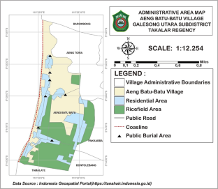
The research aims to find out what part of human activities on the outside and inside played in the destruction of the coastal area; in this case, it examines human activities carried out by residents and sand mining entrepreneurs around the north Galesong Sea, which have an impact on change structure of land use and abrasion of coastal areas—using a quantitative paradigm with quantitative methods as the primary method and qualitative as support. The quantitative method uses a geographic approach, namely a spatial approach using a Geographic Information System in its analysis. GIS uses spatially based data, namely geographically oriented data. Data used in this study are land use maps and village shorelines. The qualitative method used descriptive case studies. Qualitative data: The population of this study is Aeng Batu village. There are two types of research samples, namely area and human samples; area samples are taken from the description of conditions when abrasion occurs and after post-abrasion repairs occur. For the human sample, the respondents were community leaders, village officials, and the community to find out the purpose of digging beach sand and dumping trash on the beach in ex-dug holes. The data is described and supplemented with photographs of actual conditions in the field—analysis techniques using analytical descriptions. In conclusion, damage to coastal land caused by human activities does not only come from mining at sea but also the activities of residents who use beach land and beach sand (for residential construction and garbage disposal), the physical shape of the beach, the damage is exacerbated by high rainfall, wind, and waves, especially during the rainy season.
本研究的目的是了解人类的外部和内部活动在沿海地区的破坏中所起的作用;在这种情况下,本研究采用定量范式,以定量方法为主,定性方法为辅,考察了加雷松海北部周围居民和采砂企业主所进行的人类活动,这些活动对土地利用结构的变化和沿海地区的磨损产生了影响。定量方法采用地理方法,即利用地理信息系统进行分析的空间方法。地理信息系统使用基于空间的数据,即地理导向数据。本研究使用的数据是土地利用图和村庄海岸线。定性方法采用描述性案例研究。定性数据:研究对象为 Aeng Batu 村。研究样本分为两种,即区域样本和人类样本;区域样本取自磨损发生时和磨损后修复时的情况描述。对于人类样本,受访者为社区领导、村干部和社区居民,以了解在前挖洞中挖掘沙滩沙和在沙滩上倾倒垃圾的目的。利用分析描述技术对数据进行了描述,并辅以实地实际情况的照片。总之,人类活动对沿海土地造成的破坏不仅来自海上采矿,还包括居民使用海滩土地和海滩沙子的活动(用于住宅建设和垃圾处理)、海滩的物理形状、高降雨量、大风和海浪(尤其是在雨季)加剧的破坏。
期刊介绍:
The Journal of Coastal Conservation is a scientific journal for the dissemination of both theoretical and applied research on integrated and sustainable management of the terrestrial, coastal and marine environmental interface.
A thorough understanding of both the physical and the human sciences is important to the study of the spatial patterns and processes observed in terrestrial, coastal and marine systems set in the context of past, present and future social and economic developments. This includes multidisciplinary and integrated knowledge and understanding of: physical geography, coastal geomorphology, sediment dynamics, hydrodynamics, soil science, hydrology, plant and animal ecology, vegetation science, biogeography, landscape ecology, recreation and tourism studies, urban and human ecology, coastal engineering and spatial planning, coastal zone management, and marine resource management.
 求助内容:
求助内容: 应助结果提醒方式:


