Kevin Musungu, Timothy Dube, Julian Smit, Moreblessings Shoko
{"title":"Using UAV multispectral photography to discriminate plant species in a seep wetland of the Fynbos Biome","authors":"Kevin Musungu, Timothy Dube, Julian Smit, Moreblessings Shoko","doi":"10.1007/s11273-023-09971-y","DOIUrl":null,"url":null,"abstract":"<p>Wetlands harbour a wide range of vital ecosystems. Hence, mapping wetlands is essential to conserving the ecosystems that depend on them. However, the physical nature of wetlands makes fieldwork difficult and potentially erroneous. This study used multispectral UAV aerial photography to map ten wetland plant species in the Fynbos Biome in the Steenbras Nature Reserve. We developed a methodology that used K-Nearest Neighbour (KNN), Support Vector Machine (SVM), and Random Forest (RF) machine learning algorithms to classify ten wetland plant species using the preselected bands and spectral indices. The study identified Normalized green red difference index (NGRDI), Red Green (RG) index, Green, Log Red Edge (LogRE), Normalized Difference Red-Edge (NDRE), Chlorophyll Index Red-Edge (CIRE), Green Ratio Vegetation Index (GRVI), Normalized Difference Water Index (NDWI), Green Normalized Difference Vegetation Index <b>(</b>GNDVI) and Red as pertinent bands and indices for classifying wetland plant species in the Proteaceae, Iridaceae, Restionaceae, Ericaceae, Asteraceae and Cyperaceae families. The classification had an overall accuracy of 87.4% and kappa accuracy of 0.85. Thus, the findings are pertinent to understanding the spectral characteristics of these endemic species. The study demonstrates the potential for UAV-based remote sensing of these endemic species.</p>","PeriodicalId":49363,"journal":{"name":"Wetlands Ecology and Management","volume":"26 1","pages":""},"PeriodicalIF":1.6000,"publicationDate":"2024-01-06","publicationTypes":"Journal Article","fieldsOfStudy":null,"isOpenAccess":false,"openAccessPdf":"","citationCount":"0","resultStr":null,"platform":"Semanticscholar","paperid":null,"PeriodicalName":"Wetlands Ecology and Management","FirstCategoryId":"93","ListUrlMain":"https://doi.org/10.1007/s11273-023-09971-y","RegionNum":4,"RegionCategory":"环境科学与生态学","ArticlePicture":[],"TitleCN":null,"AbstractTextCN":null,"PMCID":null,"EPubDate":"","PubModel":"","JCR":"Q4","JCRName":"ENVIRONMENTAL SCIENCES","Score":null,"Total":0}
引用次数: 0
Abstract
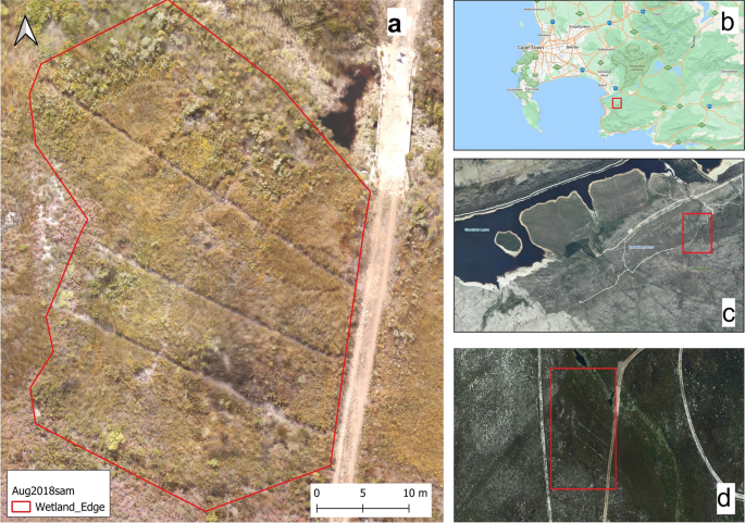
Wetlands harbour a wide range of vital ecosystems. Hence, mapping wetlands is essential to conserving the ecosystems that depend on them. However, the physical nature of wetlands makes fieldwork difficult and potentially erroneous. This study used multispectral UAV aerial photography to map ten wetland plant species in the Fynbos Biome in the Steenbras Nature Reserve. We developed a methodology that used K-Nearest Neighbour (KNN), Support Vector Machine (SVM), and Random Forest (RF) machine learning algorithms to classify ten wetland plant species using the preselected bands and spectral indices. The study identified Normalized green red difference index (NGRDI), Red Green (RG) index, Green, Log Red Edge (LogRE), Normalized Difference Red-Edge (NDRE), Chlorophyll Index Red-Edge (CIRE), Green Ratio Vegetation Index (GRVI), Normalized Difference Water Index (NDWI), Green Normalized Difference Vegetation Index (GNDVI) and Red as pertinent bands and indices for classifying wetland plant species in the Proteaceae, Iridaceae, Restionaceae, Ericaceae, Asteraceae and Cyperaceae families. The classification had an overall accuracy of 87.4% and kappa accuracy of 0.85. Thus, the findings are pertinent to understanding the spectral characteristics of these endemic species. The study demonstrates the potential for UAV-based remote sensing of these endemic species.
期刊介绍:
Wetlands Ecology and Management is an international journal that publishes authoritative and original articles on topics relevant to freshwater, brackish and marine coastal wetland ecosystems. The Journal serves as a multi-disciplinary forum covering key issues in wetlands science, management, policy and economics. As such, Wetlands Ecology and Management aims to encourage the exchange of information between environmental managers, pure and applied scientists, and national and international authorities on wetlands policy and ecological economics.
 求助内容:
求助内容: 应助结果提醒方式:


