Assessing the accuracy of georeferenced landcover data derived from oblique imagery using machine learning
IF 4.3
2区 环境科学与生态学
Q1 ECOLOGY
引用次数: 0
Abstract
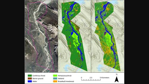
Repeat photography offers distinctive insights into ecological change, with ground-based oblique photographs often predating early aerial images by decades. However, the oblique angle of the photographs presents challenges for extracting and analyzing ecological information using traditional remote sensing approaches. Several innovative methods have been developed for analyzing repeat photographs, but none offer a comprehensive end-to-end workflow incorporating image classification and georeferencing to produce quantifiable landcover data. In this paper, we provide an overview of two new tools, an automated deep learning classifier and intuitive georeferencing tool, and describe how they are used to derive landcover data from 19 images associated with the Mountain Legacy Project, a research team that works with the world's largest collection of systematic high-resolution historic mountain photographs. We then combined these data to produce a contemporary landcover map for a study area in Jasper National Park, Canada. We assessed georeferencing accuracy by calculating the root-mean-square error and mean displacement for a subset of the images, which was 4.6 and 3.7 m, respectively. Overall classification accuracy of the landcover map produced from oblique images was 68%, which was comparable to landcover data produced from aerial imagery using a conventional classification method. The new workflow advances the use of repeat photographs for yielding quantitative landcover data. It has several advantages over existing methods including the ability to produce quick and consistent image classifications with little human input, and accurately georeference and combine these data to generate landcover maps for large areas.

利用机器学习评估从斜射图像中提取的地理坐标土地覆盖数据的准确性
重复摄影为了解生态变化提供了独特的视角,地面拍摄的斜角照片往往比早期的航空照片早几十年。然而,照片的倾斜角度给使用传统遥感方法提取和分析生态信息带来了挑战。目前已开发出几种分析重复照片的创新方法,但没有一种方法能提供全面的端到端工作流程,将图像分类和地理参照结合起来,生成可量化的土地覆盖数据。在本文中,我们概述了两款新工具--自动深度学习分类器和直观的地理参照工具,并介绍了如何使用这两款工具从与山区遗产项目相关的 19 幅图像中获取土地覆盖率数据。然后,我们结合这些数据,为加拿大贾斯珀国家公园的一个研究区域绘制了一幅当代土地覆盖图。我们通过计算图像子集的均方根误差和平均位移来评估地理参照的准确性,误差和位移分别为 4.6 米和 3.7 米。利用斜面图像制作的土地覆盖物地图的总体分类准确率为 68%,与利用传统分类方法从航空图像制作的土地覆盖物数据相当。新的工作流程推进了重复照片在获取定量土地覆盖数据方面的应用。与现有方法相比,它有几个优势,包括只需少量人工输入就能快速、一致地进行图像分类,并能准确地进行地理参照和组合这些数据,生成大面积的土地覆盖物地图。
本文章由计算机程序翻译,如有差异,请以英文原文为准。
求助全文
约1分钟内获得全文
求助全文
来源期刊

Remote Sensing in Ecology and Conservation
Earth and Planetary Sciences-Computers in Earth Sciences
CiteScore
9.80
自引率
5.50%
发文量
69
审稿时长
18 weeks
期刊介绍:
emote Sensing in Ecology and Conservation provides a forum for rapid, peer-reviewed publication of novel, multidisciplinary research at the interface between remote sensing science and ecology and conservation. The journal prioritizes findings that advance the scientific basis of ecology and conservation, promoting the development of remote-sensing based methods relevant to the management of land use and biological systems at all levels, from populations and species to ecosystems and biomes. The journal defines remote sensing in its broadest sense, including data acquisition by hand-held and fixed ground-based sensors, such as camera traps and acoustic recorders, and sensors on airplanes and satellites. The intended journal’s audience includes ecologists, conservation scientists, policy makers, managers of terrestrial and aquatic systems, remote sensing scientists, and students.
Remote Sensing in Ecology and Conservation is a fully open access journal from Wiley and the Zoological Society of London. Remote sensing has enormous potential as to provide information on the state of, and pressures on, biological diversity and ecosystem services, at multiple spatial and temporal scales. This new publication provides a forum for multidisciplinary research in remote sensing science, ecological research and conservation science.
 求助内容:
求助内容: 应助结果提醒方式:


