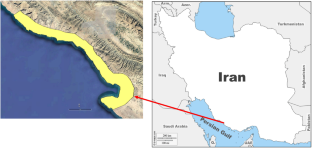
{"title":"Environmental sensitivity index mapping for the oil spill at a heavily industrialized area on the Northern Coast of the Persian Gulf","authors":"Alireza Hemmati, Fazel Amiri, Esmaeil Kouhgardi","doi":"10.1007/s11852-023-01021-2","DOIUrl":null,"url":null,"abstract":"<p>Determining the environmental sensitivity of an area provides an early warning of potential land-use problems that can determine the location and extent of possible adverse effects for preventive planning and decision-making. The Coastal Zone Sensitivity Map supports the development of response strategies in potential oil spill programs. This project studies the 187-km coastline north of the Persian Gulf, including a special economic zone and a protected area. The proximity of various oil and gas development projects to the national park located in this area, and the possible threats of these industrial activities to the park's environment, highlight the importance of this study more than ever before. To prepare the environmental sensitivity map of this area, we studied the sensitive vegetation in the area, as well as the presence of birds, existing animal cover, susceptible organisms, fish, aquatic organisms, and types of beaches. This study revealed the existence of various species with conservation value in this area, including 13 species of birds, four species of reptiles and amphibians, nine species of mammals, five species of marine animals, and one plant species. By preparing an environmental sensitivity map, local authorities and decision-makers gain valuable insights into identifying vulnerable areas during oil spills or incidents that pose risks to the environment.</p>","PeriodicalId":48909,"journal":{"name":"Journal of Coastal Conservation","volume":"7 1","pages":""},"PeriodicalIF":1.9000,"publicationDate":"2024-01-04","publicationTypes":"Journal Article","fieldsOfStudy":null,"isOpenAccess":false,"openAccessPdf":"","citationCount":"0","resultStr":null,"platform":"Semanticscholar","paperid":null,"PeriodicalName":"Journal of Coastal Conservation","FirstCategoryId":"93","ListUrlMain":"https://doi.org/10.1007/s11852-023-01021-2","RegionNum":4,"RegionCategory":"环境科学与生态学","ArticlePicture":[],"TitleCN":null,"AbstractTextCN":null,"PMCID":null,"EPubDate":"","PubModel":"","JCR":"Q4","JCRName":"ENVIRONMENTAL SCIENCES","Score":null,"Total":0}
引用次数: 0
Abstract
Determining the environmental sensitivity of an area provides an early warning of potential land-use problems that can determine the location and extent of possible adverse effects for preventive planning and decision-making. The Coastal Zone Sensitivity Map supports the development of response strategies in potential oil spill programs. This project studies the 187-km coastline north of the Persian Gulf, including a special economic zone and a protected area. The proximity of various oil and gas development projects to the national park located in this area, and the possible threats of these industrial activities to the park's environment, highlight the importance of this study more than ever before. To prepare the environmental sensitivity map of this area, we studied the sensitive vegetation in the area, as well as the presence of birds, existing animal cover, susceptible organisms, fish, aquatic organisms, and types of beaches. This study revealed the existence of various species with conservation value in this area, including 13 species of birds, four species of reptiles and amphibians, nine species of mammals, five species of marine animals, and one plant species. By preparing an environmental sensitivity map, local authorities and decision-makers gain valuable insights into identifying vulnerable areas during oil spills or incidents that pose risks to the environment.
期刊介绍:
The Journal of Coastal Conservation is a scientific journal for the dissemination of both theoretical and applied research on integrated and sustainable management of the terrestrial, coastal and marine environmental interface.
A thorough understanding of both the physical and the human sciences is important to the study of the spatial patterns and processes observed in terrestrial, coastal and marine systems set in the context of past, present and future social and economic developments. This includes multidisciplinary and integrated knowledge and understanding of: physical geography, coastal geomorphology, sediment dynamics, hydrodynamics, soil science, hydrology, plant and animal ecology, vegetation science, biogeography, landscape ecology, recreation and tourism studies, urban and human ecology, coastal engineering and spatial planning, coastal zone management, and marine resource management.
 求助内容:
求助内容: 应助结果提醒方式:


