Kamrul Islam, Sajib Sarker, Golam Morsad, Mohd. Fardeen Khan, Arif Chowdhury, Syed Labib Ul Islam
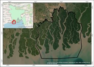
{"title":"Spatial–temporal changes of shoreline and Vegetation: Impacts on mangrove cover along the Sundarbans area, Bangladesh","authors":"Kamrul Islam, Sajib Sarker, Golam Morsad, Mohd. Fardeen Khan, Arif Chowdhury, Syed Labib Ul Islam","doi":"10.1007/s11852-023-01016-z","DOIUrl":null,"url":null,"abstract":"<p>Land use change is a global issue, and different regions of Bangladesh are experiencing land use changes at different scales. The Sundarbans is one of the largest mangrove forests that provide resources to the local communities, act as a sink for CO<sub>2</sub>, and protect the coastal zone from natural disasters. Sundarbans is also being affected by land use change and deteriorating rapidly, posing a threat to mangroves and wildlife. This is mainly driven by the unplanned expansion of open land, deforestation, and filling up the water bodies. Evaluating the shoreline food web and the interaction of water and land necessitates quantitatively assessing shoreline movement patterns over time. This study aimed to understand the spatial–temporal changes in shoreline and vegetation from 1981 to 2021 considering the mangrove cover along the Sundarbans in Bangladesh. To fulfill the objectives, the Digital Shoreline Analysis System was used to measure the shoreline change, and the vegetation changes were assessed by using the Normalized Difference Vegetation Index (NDVI) using Landsat satellite data. The analysis of NDVI revealed that the mangrove stress level is increasing rapidly. In the last 20 years, the high-level vegetation has decreased by 5.01%, the moderate level by 9.61% & the low level by 6.99%. Moreover, the shoreline change analysis found that from 1980 to 1990 the erosion was 143.95 sq. km and the accretion was 110.9 sq. km. The findings of this study may help policymakers make informed decisions, and improve their plans for the sustainable development of the region.</p>","PeriodicalId":48909,"journal":{"name":"Journal of Coastal Conservation","volume":"3 1","pages":""},"PeriodicalIF":1.9000,"publicationDate":"2023-12-29","publicationTypes":"Journal Article","fieldsOfStudy":null,"isOpenAccess":false,"openAccessPdf":"","citationCount":"0","resultStr":null,"platform":"Semanticscholar","paperid":null,"PeriodicalName":"Journal of Coastal Conservation","FirstCategoryId":"93","ListUrlMain":"https://doi.org/10.1007/s11852-023-01016-z","RegionNum":4,"RegionCategory":"环境科学与生态学","ArticlePicture":[],"TitleCN":null,"AbstractTextCN":null,"PMCID":null,"EPubDate":"","PubModel":"","JCR":"Q4","JCRName":"ENVIRONMENTAL SCIENCES","Score":null,"Total":0}
引用次数: 0
Abstract
Land use change is a global issue, and different regions of Bangladesh are experiencing land use changes at different scales. The Sundarbans is one of the largest mangrove forests that provide resources to the local communities, act as a sink for CO2, and protect the coastal zone from natural disasters. Sundarbans is also being affected by land use change and deteriorating rapidly, posing a threat to mangroves and wildlife. This is mainly driven by the unplanned expansion of open land, deforestation, and filling up the water bodies. Evaluating the shoreline food web and the interaction of water and land necessitates quantitatively assessing shoreline movement patterns over time. This study aimed to understand the spatial–temporal changes in shoreline and vegetation from 1981 to 2021 considering the mangrove cover along the Sundarbans in Bangladesh. To fulfill the objectives, the Digital Shoreline Analysis System was used to measure the shoreline change, and the vegetation changes were assessed by using the Normalized Difference Vegetation Index (NDVI) using Landsat satellite data. The analysis of NDVI revealed that the mangrove stress level is increasing rapidly. In the last 20 years, the high-level vegetation has decreased by 5.01%, the moderate level by 9.61% & the low level by 6.99%. Moreover, the shoreline change analysis found that from 1980 to 1990 the erosion was 143.95 sq. km and the accretion was 110.9 sq. km. The findings of this study may help policymakers make informed decisions, and improve their plans for the sustainable development of the region.
期刊介绍:
The Journal of Coastal Conservation is a scientific journal for the dissemination of both theoretical and applied research on integrated and sustainable management of the terrestrial, coastal and marine environmental interface.
A thorough understanding of both the physical and the human sciences is important to the study of the spatial patterns and processes observed in terrestrial, coastal and marine systems set in the context of past, present and future social and economic developments. This includes multidisciplinary and integrated knowledge and understanding of: physical geography, coastal geomorphology, sediment dynamics, hydrodynamics, soil science, hydrology, plant and animal ecology, vegetation science, biogeography, landscape ecology, recreation and tourism studies, urban and human ecology, coastal engineering and spatial planning, coastal zone management, and marine resource management.
 求助内容:
求助内容: 应助结果提醒方式:


