Heling Li, Liang Tang, Tim T. Werner, Zhengmeng Hou, Fan Meng, Jingjing Li
{"title":"Spatiotemporal mapping of (ultra-)mafic magmatic mine areas: Implications of economic and political realities in China","authors":"Heling Li, Liang Tang, Tim T. Werner, Zhengmeng Hou, Fan Meng, Jingjing Li","doi":"10.1002/dug2.12067","DOIUrl":null,"url":null,"abstract":"<p>The spatiotemporal extension/expansion of mine areas is affected by multiple factors. So far, very little has been done to examine the interaction between mine areas and political or economic realities. The (ultra-)mafic magmatic mines in China played a specific role in supporting national development and providing an ideal research subject for monitoring their interrelationship. In this study, remote sensing and mining-related GIS data were used to identify and analyze 1233 (ultra-)mafic magmatic mine area polygons in China, which covered approximately 322.96 km<sup>2</sup> of land and included a V–Ti–Fe mine, a copper–nickel mine, a chromite mine, an asbestos mine, and a diamond mine. It was found that (1) the areal expansion of mines is significantly related to the mine types, perimeter, topography, and population density. (2) The mine area variation also reflects market and policy realities. The temporal expansion of the mine area from 2010 to 2020 followed an S-shaped pattern (with the turning point occurring in 2014), closely related to iron overcapacity and tightened mining policies. (3) The complexity (<i>D</i>) of the mine area may reflect mine design and excavation practices. To be specific, lower <i>D</i> indicates early-stage or artisanal/small-scale mining, whereas higher <i>D</i> represents large-scale mining. This study demonstrates that the detailed mapping of mine land can serve as an indicator to implement mining-related market and policy changes. The (ultra-)mafic mines area data set can be accessed at https://zenodo.org/record/7636616#.Y-p0uXaZOa0.</p>","PeriodicalId":100363,"journal":{"name":"Deep Underground Science and Engineering","volume":"3 1","pages":"91-102"},"PeriodicalIF":0.0000,"publicationDate":"2023-12-07","publicationTypes":"Journal Article","fieldsOfStudy":null,"isOpenAccess":false,"openAccessPdf":"https://onlinelibrary.wiley.com/doi/epdf/10.1002/dug2.12067","citationCount":"0","resultStr":null,"platform":"Semanticscholar","paperid":null,"PeriodicalName":"Deep Underground Science and Engineering","FirstCategoryId":"1085","ListUrlMain":"https://onlinelibrary.wiley.com/doi/10.1002/dug2.12067","RegionNum":0,"RegionCategory":null,"ArticlePicture":[],"TitleCN":null,"AbstractTextCN":null,"PMCID":null,"EPubDate":"","PubModel":"","JCR":"","JCRName":"","Score":null,"Total":0}
引用次数: 0
Abstract
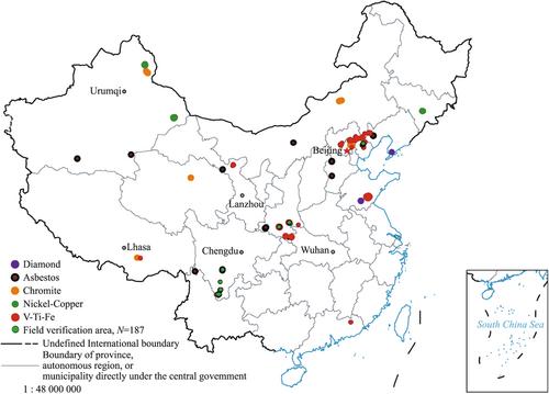
The spatiotemporal extension/expansion of mine areas is affected by multiple factors. So far, very little has been done to examine the interaction between mine areas and political or economic realities. The (ultra-)mafic magmatic mines in China played a specific role in supporting national development and providing an ideal research subject for monitoring their interrelationship. In this study, remote sensing and mining-related GIS data were used to identify and analyze 1233 (ultra-)mafic magmatic mine area polygons in China, which covered approximately 322.96 km2 of land and included a V–Ti–Fe mine, a copper–nickel mine, a chromite mine, an asbestos mine, and a diamond mine. It was found that (1) the areal expansion of mines is significantly related to the mine types, perimeter, topography, and population density. (2) The mine area variation also reflects market and policy realities. The temporal expansion of the mine area from 2010 to 2020 followed an S-shaped pattern (with the turning point occurring in 2014), closely related to iron overcapacity and tightened mining policies. (3) The complexity (D) of the mine area may reflect mine design and excavation practices. To be specific, lower D indicates early-stage or artisanal/small-scale mining, whereas higher D represents large-scale mining. This study demonstrates that the detailed mapping of mine land can serve as an indicator to implement mining-related market and policy changes. The (ultra-)mafic mines area data set can be accessed at https://zenodo.org/record/7636616#.Y-p0uXaZOa0.

 求助内容:
求助内容: 应助结果提醒方式:


