{"title":"Structural Conditions for Localization of Barite Mineralization in Tectonic Evolution of the Southern Sanandaj Zone, Iran","authors":"A. Alizadeh, C. Hoseini, E. Haji","doi":"10.1134/s001685212306002x","DOIUrl":null,"url":null,"abstract":"<h3 data-test=\"abstract-sub-heading\">Abstract</h3><p>Barite mineralization is visible as veins in the Kuik‒Qureq area, southern part of Sanandaj zone, Western Iran. Geological and structural maps of the area were prepared using remote sensing data and field achievements. Statistical analysis of fractures included the ratio of distance and length to abundance, and also the calculation of the fractal dimension of fractures. This analysis indicates the role of structural controls on the barite mineralization in the region. Petro-fabrics were used to determine displacement and contribution of faults in barite mineralization. Geometric analysis using rose diagrams determined that the trends of the dominant fractures are N‒S and NN‒S, NNW‒SSE, WNW‒ESE and NNE‒SSW, and the main barite mineralization was formed along these faults. A tectonic model is presented for the region based on classifying fractures by azimuth and features observed in thin section. According to the proposed model, at least four stages of tectonic deformation affected the region and during these the direction of the σ<sub>1</sub> axis changed in a clockwise direction. Barite mineralization mainly occurred in two stages: the first and main stage when first order fractures formed with the N‒S trend, and during the third deformation stage when secondary barite was deposited in third order fractures with an E‒W trend.</p>","PeriodicalId":55097,"journal":{"name":"Geotectonics","volume":"4 1","pages":""},"PeriodicalIF":0.8000,"publicationDate":"2023-12-10","publicationTypes":"Journal Article","fieldsOfStudy":null,"isOpenAccess":false,"openAccessPdf":"","citationCount":"0","resultStr":null,"platform":"Semanticscholar","paperid":null,"PeriodicalName":"Geotectonics","FirstCategoryId":"89","ListUrlMain":"https://doi.org/10.1134/s001685212306002x","RegionNum":4,"RegionCategory":"地球科学","ArticlePicture":[],"TitleCN":null,"AbstractTextCN":null,"PMCID":null,"EPubDate":"","PubModel":"","JCR":"Q3","JCRName":"GEOCHEMISTRY & GEOPHYSICS","Score":null,"Total":0}
引用次数: 0
Abstract
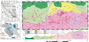
Barite mineralization is visible as veins in the Kuik‒Qureq area, southern part of Sanandaj zone, Western Iran. Geological and structural maps of the area were prepared using remote sensing data and field achievements. Statistical analysis of fractures included the ratio of distance and length to abundance, and also the calculation of the fractal dimension of fractures. This analysis indicates the role of structural controls on the barite mineralization in the region. Petro-fabrics were used to determine displacement and contribution of faults in barite mineralization. Geometric analysis using rose diagrams determined that the trends of the dominant fractures are N‒S and NN‒S, NNW‒SSE, WNW‒ESE and NNE‒SSW, and the main barite mineralization was formed along these faults. A tectonic model is presented for the region based on classifying fractures by azimuth and features observed in thin section. According to the proposed model, at least four stages of tectonic deformation affected the region and during these the direction of the σ1 axis changed in a clockwise direction. Barite mineralization mainly occurred in two stages: the first and main stage when first order fractures formed with the N‒S trend, and during the third deformation stage when secondary barite was deposited in third order fractures with an E‒W trend.
期刊介绍:
Geotectonics publishes articles on general and regional tectonics, structural geology, geodynamics, and experimental tectonics and considers the relation of tectonics to the deep structure of the earth, magmatism, metamorphism, and mineral resources.
 求助内容:
求助内容: 应助结果提醒方式:


