N. A. Gubin, E. E. Kononov, A. S. Poletaev, A. G. Chensky
{"title":"Underwater Relief and Sediments in the Area of the St. Petersburg Mud Volcano (Lake Baikal)","authors":"N. A. Gubin, E. E. Kononov, A. S. Poletaev, A. G. Chensky","doi":"10.1134/s1875372822030040","DOIUrl":null,"url":null,"abstract":"<h3 data-test=\"abstract-sub-heading\">Abstract</h3><p>A combined analysis is made of the structure of the St. Petersburg mud volcano and the lake bottom surface surrounding it using bathymetric, seismoacoustic, backscatter, and water column data. A high-precision digital elevation model with a horizontal resolution of up to 10 m has been developed for the bottom surface in the area of the volcano. By analyzing the resulting model, it is possible to update the morphometric parameters of the underwater structure under consideration and prepare a detailed morphological description. It has been found that the volcanic edifice consists of several ridgelike parts located on the wings of the Gidratnyi Fault and crossing it. A canyon-shaped and curved in plan 800-m wide valley was mapped to the southeast of the fault. A graphical representation of backscatter data with separation by types of sedimentary layers is created via a comparison of the intensity of the reflected signal and expected mathematical model values. Based on the results of data analysis, it has been established that the mud volcano mainly consists of clay with the possible inclusion of relatively large fragments (up to 10 cm). Presumably there are also large fragments on the bottom surface around the volcano; however, fine-grained fractions (sandy, clayey, and silty) are dominant. A three-dimensional visualization of the water column data is presented for the study area with the detected outcrops of gas in the form of two gas flares with the observed heights of 800 and 700 m. According to a statistical sample of the values of the reflected signal amplitudes, the intensity of gas release in the flares differs by approximately 7 times. The seismoacoustic data of the chirp profiler indicate the possible presence of gas hydrates.</p>","PeriodicalId":44739,"journal":{"name":"Geography and Natural Resources","volume":"44 1","pages":""},"PeriodicalIF":0.3000,"publicationDate":"2022-12-08","publicationTypes":"Journal Article","fieldsOfStudy":null,"isOpenAccess":false,"openAccessPdf":"","citationCount":"0","resultStr":null,"platform":"Semanticscholar","paperid":null,"PeriodicalName":"Geography and Natural Resources","FirstCategoryId":"1085","ListUrlMain":"https://doi.org/10.1134/s1875372822030040","RegionNum":0,"RegionCategory":null,"ArticlePicture":[],"TitleCN":null,"AbstractTextCN":null,"PMCID":null,"EPubDate":"","PubModel":"","JCR":"Q4","JCRName":"GEOGRAPHY","Score":null,"Total":0}
引用次数: 0
Abstract
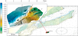
A combined analysis is made of the structure of the St. Petersburg mud volcano and the lake bottom surface surrounding it using bathymetric, seismoacoustic, backscatter, and water column data. A high-precision digital elevation model with a horizontal resolution of up to 10 m has been developed for the bottom surface in the area of the volcano. By analyzing the resulting model, it is possible to update the morphometric parameters of the underwater structure under consideration and prepare a detailed morphological description. It has been found that the volcanic edifice consists of several ridgelike parts located on the wings of the Gidratnyi Fault and crossing it. A canyon-shaped and curved in plan 800-m wide valley was mapped to the southeast of the fault. A graphical representation of backscatter data with separation by types of sedimentary layers is created via a comparison of the intensity of the reflected signal and expected mathematical model values. Based on the results of data analysis, it has been established that the mud volcano mainly consists of clay with the possible inclusion of relatively large fragments (up to 10 cm). Presumably there are also large fragments on the bottom surface around the volcano; however, fine-grained fractions (sandy, clayey, and silty) are dominant. A three-dimensional visualization of the water column data is presented for the study area with the detected outcrops of gas in the form of two gas flares with the observed heights of 800 and 700 m. According to a statistical sample of the values of the reflected signal amplitudes, the intensity of gas release in the flares differs by approximately 7 times. The seismoacoustic data of the chirp profiler indicate the possible presence of gas hydrates.
期刊介绍:
Geography and Natural Resources publishes information on research results in the field of geographical studies of nature, the economy, and the population. It provides ample coverage of the geographical aspects related to solving major economic problems, with special emphasis on regional nature management and environmental protection, geographical forecasting, integral regional research developments, modelling of natural processes, and on the advancement of mapping techniques. The journal publishes contributions on monitoring studies, geographical research abroad, as well as discussions on the theory of science.

 求助内容:
求助内容: 应助结果提醒方式:


