{"title":"Associations Between Street Connectivity and Poverty","authors":"Francisco Benita","doi":"10.1007/s11067-022-09561-0","DOIUrl":null,"url":null,"abstract":"<p>Patterns of street connectivity and poverty in the US and Mexico are investigated by means of spatial analysis and statistical techniques. The evaluation is conducted at three levels of spatial aggregation: 389 (<i>74</i>) metropolitan areas, 3,106 (<i>2,432</i>) counties (<i>municipalities</i>), and 58,953 (<i>27,413</i>) census tracts of the US (<i>Mexico</i>). The article explores whether the physical configuration of the street network may affect geographical concentration of poverty. To quantitatively measure differences in network patterns, we consider six metrics: street density, intersection density, regularity, betweenness, closeness and information centrality. The results reveal that relationships between connectivity and poverty have opposite signs in the two countries. For example, whereas intersection density and betweenness centrality positively influence the spatial agglomeration of low-income households in the US, the reverse pattern of association is observable in Mexico. Furthermore, differences in street layouts between low-income and high-income neighborhoods are more pronounced among Mexican cities.</p>","PeriodicalId":501141,"journal":{"name":"Networks and Spatial Economics","volume":"20 2","pages":""},"PeriodicalIF":0.0000,"publicationDate":"2022-04-14","publicationTypes":"Journal Article","fieldsOfStudy":null,"isOpenAccess":false,"openAccessPdf":"","citationCount":"2","resultStr":null,"platform":"Semanticscholar","paperid":null,"PeriodicalName":"Networks and Spatial Economics","FirstCategoryId":"1085","ListUrlMain":"https://doi.org/10.1007/s11067-022-09561-0","RegionNum":0,"RegionCategory":null,"ArticlePicture":[],"TitleCN":null,"AbstractTextCN":null,"PMCID":null,"EPubDate":"","PubModel":"","JCR":"","JCRName":"","Score":null,"Total":0}
引用次数: 2
Abstract
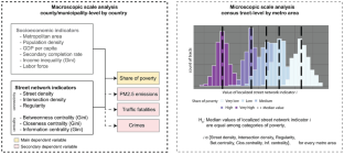
Patterns of street connectivity and poverty in the US and Mexico are investigated by means of spatial analysis and statistical techniques. The evaluation is conducted at three levels of spatial aggregation: 389 (74) metropolitan areas, 3,106 (2,432) counties (municipalities), and 58,953 (27,413) census tracts of the US (Mexico). The article explores whether the physical configuration of the street network may affect geographical concentration of poverty. To quantitatively measure differences in network patterns, we consider six metrics: street density, intersection density, regularity, betweenness, closeness and information centrality. The results reveal that relationships between connectivity and poverty have opposite signs in the two countries. For example, whereas intersection density and betweenness centrality positively influence the spatial agglomeration of low-income households in the US, the reverse pattern of association is observable in Mexico. Furthermore, differences in street layouts between low-income and high-income neighborhoods are more pronounced among Mexican cities.

 求助内容:
求助内容: 应助结果提醒方式:


