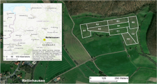
{"title":"Evaluation of Direct RTK-georeferenced UAV Images for Crop and Pasture Monitoring Using Polygon Grids","authors":"Georg Bareth, Christoph Hütt","doi":"10.1007/s41064-023-00259-7","DOIUrl":null,"url":null,"abstract":"<p>Remote sensing approaches using Unmanned Aerial Vehicles (UAVs) have become an established method to monitor agricultural systems. They enable data acquisition with multi- or hyperspectral, RGB, or LiDAR sensors. For non-destructive estimation of crop or sward traits, photogrammetric analysis using Structure from Motion and Multiview Stereopsis (SfM/MVS) has opened a new research field. SfM/MVS analysis enables the monitoring of plant height and plant growth to determine, e.g., biomass. A drawback in the SfM/MVS analysis workflow is that it requires ground control points (GCPs), making it unsuitable for monitoring managed fields which are typically larger than 1 ha. Consequently, accurately georeferenced image data acquisition would be beneficial as it would enable data analysis without GCPs. In the last decade, substantial progress has been achieved in integrating real-time kinematic (RTK) positioning in UAVs, which can potentially provide the desired accuracy in cm range. Therefore, to evaluate the accuracy of crop and sward height analysis, we investigated two SfM/MVS workflows for RTK-tagged UAV data, (I) without and (II) with GCPs. The results clearly indicate that direct RTK-georeferenced UAV data perform well in workflow (I) without using any GCPs (RMSE for <i>Z</i> is 2.8 cm) compared to the effectiveness in workflow (II), which included the GCPs in the SfM/MVS analysis (RMSE for <i>Z</i> is 1.7 cm). Both data sets have the same Ground Sampling Distance (GSD) of 2.46 cm. We conclude that RTK-equipped UAVs enable the monitoring of crop and sward growth greater than 3 cm. At greater plant height differences, the monitoring is significantly more accurate.</p>","PeriodicalId":56035,"journal":{"name":"PFG-Journal of Photogrammetry Remote Sensing and Geoinformation Science","volume":"40 S1","pages":""},"PeriodicalIF":3.3000,"publicationDate":"2023-11-30","publicationTypes":"Journal Article","fieldsOfStudy":null,"isOpenAccess":false,"openAccessPdf":"","citationCount":"0","resultStr":null,"platform":"Semanticscholar","paperid":null,"PeriodicalName":"PFG-Journal of Photogrammetry Remote Sensing and Geoinformation Science","FirstCategoryId":"89","ListUrlMain":"https://doi.org/10.1007/s41064-023-00259-7","RegionNum":4,"RegionCategory":"地球科学","ArticlePicture":[],"TitleCN":null,"AbstractTextCN":null,"PMCID":null,"EPubDate":"","PubModel":"","JCR":"Q3","JCRName":"IMAGING SCIENCE & PHOTOGRAPHIC TECHNOLOGY","Score":null,"Total":0}
引用次数: 0
Abstract
Remote sensing approaches using Unmanned Aerial Vehicles (UAVs) have become an established method to monitor agricultural systems. They enable data acquisition with multi- or hyperspectral, RGB, or LiDAR sensors. For non-destructive estimation of crop or sward traits, photogrammetric analysis using Structure from Motion and Multiview Stereopsis (SfM/MVS) has opened a new research field. SfM/MVS analysis enables the monitoring of plant height and plant growth to determine, e.g., biomass. A drawback in the SfM/MVS analysis workflow is that it requires ground control points (GCPs), making it unsuitable for monitoring managed fields which are typically larger than 1 ha. Consequently, accurately georeferenced image data acquisition would be beneficial as it would enable data analysis without GCPs. In the last decade, substantial progress has been achieved in integrating real-time kinematic (RTK) positioning in UAVs, which can potentially provide the desired accuracy in cm range. Therefore, to evaluate the accuracy of crop and sward height analysis, we investigated two SfM/MVS workflows for RTK-tagged UAV data, (I) without and (II) with GCPs. The results clearly indicate that direct RTK-georeferenced UAV data perform well in workflow (I) without using any GCPs (RMSE for Z is 2.8 cm) compared to the effectiveness in workflow (II), which included the GCPs in the SfM/MVS analysis (RMSE for Z is 1.7 cm). Both data sets have the same Ground Sampling Distance (GSD) of 2.46 cm. We conclude that RTK-equipped UAVs enable the monitoring of crop and sward growth greater than 3 cm. At greater plant height differences, the monitoring is significantly more accurate.
期刊介绍:
PFG is an international scholarly journal covering the progress and application of photogrammetric methods, remote sensing technology and the interconnected field of geoinformation science. It places special editorial emphasis on the communication of new methodologies in data acquisition and new approaches to optimized processing and interpretation of all types of data which were acquired by photogrammetric methods, remote sensing, image processing and the computer-aided interpretation of such data in general. The journal hence addresses both researchers and students of these disciplines at academic institutions and universities as well as the downstream users in both the private sector and public administration.
Founded in 1926 under the former name Bildmessung und Luftbildwesen, PFG is worldwide the oldest journal on photogrammetry. It is the official journal of the German Society for Photogrammetry, Remote Sensing and Geoinformation (DGPF).
 求助内容:
求助内容: 应助结果提醒方式:


