Joshua H. Schmidt, William W. Deacy, Letty J. Hughes, Dylan T. Schertz
{"title":"Non-invasive mark–resight surveys for brown bears: Incorporating spatial information to improve landscape-scale monitoring of density and distribution","authors":"Joshua H. Schmidt, William W. Deacy, Letty J. Hughes, Dylan T. Schertz","doi":"10.1002/2688-8319.12288","DOIUrl":null,"url":null,"abstract":"Effective wildlife monitoring and management are reliant on unbiased estimators of population parameters. Most standard survey approaches ignore spatial pattern in the data although spatial relationships can be leveraged to produce more efficient designs for future surveys, thereby reducing project cost. Landscape‐scale surveys for brown bears are notoriously expensive and difficult to complete, leading to the development of a non‐invasive mark–resight aerial survey approach as a practical alternative to more commonly employed approaches for estimating brown bear density across large areas.\n\nHere we extend that model to accommodate spatial covariate information and explicitly model residual spatial autocorrelation. Using brown bear survey data from northwestern Alaska, USA from 2015 to 2021, we demonstrate how our extension can be useful in exploring ecological factors related to spatial variation in bear density and detection probability.\n\nWe found that detection probability was higher in more rugged terrain, and occurrence probability was higher at mid‐elevations where denning habitat was more prevalent and in areas with more salmon streams. The descriptive model of residual autocorrelation confirmed that additional unmeasured factors were associated with bear distribution. While these findings were not unexpected, they are very useful when considering future survey effort.\n\nUsing this information, we explored a hypothetical redesign of the 2021 brown bear survey that removed 50% of the survey subunits with elevation values below the mean, where bears were least likely to occur. We demonstrated that the resulting estimates were unbiased, suggesting that adopting the spatial approach to analysis could reduce overall project costs by ~20%–30% going forward.\n\nOverall, our work indicates that directly accounting for spatial pattern within the non‐invasive mark–resight framework has substantive advantages over the original non‐spatial approach and may be useful in increasing the amount of information available for brown bear populations.","PeriodicalId":100388,"journal":{"name":"Ecological Solutions and Evidence","volume":null,"pages":null},"PeriodicalIF":2.6000,"publicationDate":"2023-10-27","publicationTypes":"Journal Article","fieldsOfStudy":null,"isOpenAccess":false,"openAccessPdf":"https://besjournals.onlinelibrary.wiley.com/doi/epdf/10.1002/2688-8319.12288","citationCount":"0","resultStr":null,"platform":"Semanticscholar","paperid":null,"PeriodicalName":"Ecological Solutions and Evidence","FirstCategoryId":"1085","ListUrlMain":"https://onlinelibrary.wiley.com/doi/10.1002/2688-8319.12288","RegionNum":0,"RegionCategory":null,"ArticlePicture":[],"TitleCN":null,"AbstractTextCN":null,"PMCID":null,"EPubDate":"","PubModel":"","JCR":"Q2","JCRName":"ECOLOGY","Score":null,"Total":0}
引用次数: 0
Abstract
Effective wildlife monitoring and management are reliant on unbiased estimators of population parameters. Most standard survey approaches ignore spatial pattern in the data although spatial relationships can be leveraged to produce more efficient designs for future surveys, thereby reducing project cost. Landscape‐scale surveys for brown bears are notoriously expensive and difficult to complete, leading to the development of a non‐invasive mark–resight aerial survey approach as a practical alternative to more commonly employed approaches for estimating brown bear density across large areas.
Here we extend that model to accommodate spatial covariate information and explicitly model residual spatial autocorrelation. Using brown bear survey data from northwestern Alaska, USA from 2015 to 2021, we demonstrate how our extension can be useful in exploring ecological factors related to spatial variation in bear density and detection probability.
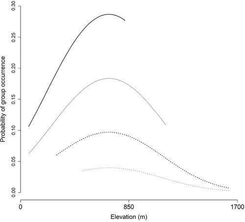
We found that detection probability was higher in more rugged terrain, and occurrence probability was higher at mid‐elevations where denning habitat was more prevalent and in areas with more salmon streams. The descriptive model of residual autocorrelation confirmed that additional unmeasured factors were associated with bear distribution. While these findings were not unexpected, they are very useful when considering future survey effort.
Using this information, we explored a hypothetical redesign of the 2021 brown bear survey that removed 50% of the survey subunits with elevation values below the mean, where bears were least likely to occur. We demonstrated that the resulting estimates were unbiased, suggesting that adopting the spatial approach to analysis could reduce overall project costs by ~20%–30% going forward.
Overall, our work indicates that directly accounting for spatial pattern within the non‐invasive mark–resight framework has substantive advantages over the original non‐spatial approach and may be useful in increasing the amount of information available for brown bear populations.

 求助内容:
求助内容: 应助结果提醒方式:


