Multi-decadal shoreline changes in Eastern Ghana—natural dynamics versus human interventions
IF 1.4
4区 地球科学
Q3 GEOSCIENCES, MULTIDISCIPLINARY
引用次数: 0
Abstract
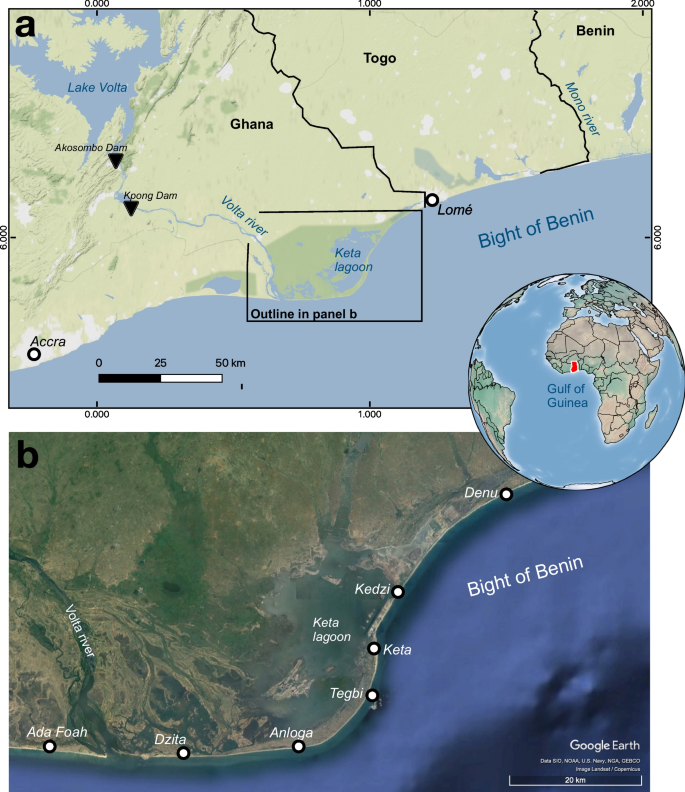
Abstract Human infrastructures, such as dams, seawalls, and ports, can affect both the sedimentary budget and nearshore hydrodynamics, enhancing and accelerating the loss or gain of coastal sediments. Understanding the processes and factors controlling beach morphodynamics is essential for implementing adequate adaptation strategies in coastal areas, particularly in those regions where coastal protection measures are scarce. This study analyzes shoreline changes in the Keta Municipal District, located in southeastern Ghana (West Africa). This area is characterized by the sedimentary input of the Volta River, forming a river delta situated to the west, i.e., updrift, of our study site. Following the construction of two dams (Akosombo and Kpong) on the Volta River in 1965 and 1982, groins and revetments have been built along the coast between 2005 and 2015 to reduce the high rates of coastal erosion in this area. Here, we explore the influence of these dams and the hard protection constructions on beach morphodynamics using historical maps and satellite images complemented by a shoreline survey undertaken with a differential GNSS in 2015. The multi-decadal evolution between 1913 and 2015 reconstructed for 90 km of shoreline suggests that local erosion rates in the region predate the construction of the two dams on the Volta River, indicating that these structures might not be the primary driver of coastal erosion in this area, as previously suggested. We emphasize that delta dynamics under conditions of high-energy longshore drift, modified by anthropogenic drivers such as sand mining, play a key role in the long-term evolution of this coast. Our results also show that the infrastructures built to halt coastal erosion result in localized erosion and accretion down-current along the coastline towards the border with Togo, highlighting the need for a transnational perspective in addressing the problems caused by coastal erosion.

加纳东部多年代际海岸线变化:自然动态与人为干预
人类的基础设施,如水坝、海堤和港口,可以影响沉积收支和近岸水动力,加强和加速沿海沉积物的损失或获得。了解控制海滩形态动力学的过程和因素对于在沿海地区实施适当的适应战略至关重要,特别是在那些海岸保护措施缺乏的地区。本研究分析了位于加纳东南部(西非)的凯塔市辖区的海岸线变化。该地区的特点是沃尔特河的沉积输入,形成了一个河流三角洲,位于我们研究地点的西部,即上升流。继1965年和1982年在沃尔特河上建造两座水坝(Akosombo和Kpong)之后,2005年至2015年期间沿海岸建造了壕沟和护岸,以减少该地区的高海岸侵蚀率。在这里,我们利用历史地图和卫星图像,并辅以2015年使用差分GNSS进行的海岸线调查,探讨了这些水坝和硬防护建筑对海滩形态动力学的影响。1913年至2015年间重建的90公里海岸线的几十年代际演变表明,该地区的局部侵蚀速率早于沃尔特河上两座水坝的建设,这表明这些结构可能不是该地区海岸侵蚀的主要驱动因素,正如之前所指出的那样。我们强调,在高能海岸漂移条件下,三角洲动力学在该海岸的长期演变中发挥了关键作用,并受到采砂等人为驱动因素的影响。我们的研究结果还表明,为阻止海岸侵蚀而建造的基础设施导致了沿海岸线向多哥边境的局部侵蚀和下流积聚,这突出了在解决海岸侵蚀引起的问题时需要跨国视角。
本文章由计算机程序翻译,如有差异,请以英文原文为准。
求助全文
约1分钟内获得全文
求助全文
来源期刊

Geo-Marine Letters
地学-地球科学综合
CiteScore
5.30
自引率
0.00%
发文量
16
审稿时长
>12 weeks
期刊介绍:
Geo-Marine Letters is an international peer-reviewed journal focussing on the rapid publication of concise original studies and reviews dealing with processes, products and techniques in marine geology, geophysics, and geochemistry. Coverage spans
- structural geology, including plate tectonics of recent active and passive margins
- sea-bed morphology, physiography and morphodynamics
- sediment transport, depositional processes and sedimentary facies analysis
- stratigraphy, basin analysis and paleoenvironmental reconstruction
- sea-level history, paleoproductivity, gas hydrates, salt domes and brines
- sediment-water interaction and organism-sediment relationships
- geochemical tracers, stable isotopes and authigenic mineral formation
- geotechnical properties and application of new geo-marine techniques, and more.
In addition to regular articles, reviews, discussion/reply articles and technical papers, Geo-Marine Letters welcomes contributions by guest editors in the form of conference/workshop proceedings, or bundles of papers dealing with specific themes.
 求助内容:
求助内容: 应助结果提醒方式:


