Comparison of different pilot point parameterization strategies when measurements are unevenly distributed in space

IF 2.4 3区 地球科学 Q2 GEOSCIENCES, MULTIDISCIPLINARY
Ryma Aissat, Alexandre Pryet, Marc Saltel, Alain Dupuy
{"title":"Comparison of different pilot point parameterization strategies when measurements are unevenly distributed in space","authors":"Ryma Aissat, Alexandre Pryet, Marc Saltel, Alain Dupuy","doi":"10.1007/s10040-023-02737-z","DOIUrl":null,"url":null,"abstract":"Abstract The parameterization of spatially distributed hydraulic properties is one of the most crucial steps in groundwater modeling. A common approach is to estimate hydraulic properties at a set of pilot points and interpolate the values at each model cell. Despite the popularity of this method, several questions remain about the optimum number and distribution of pilot points, which are determining factors for the efficiency of the method. This study proposes a strategy for optimal pilot point parameterization that minimizes the number of parameters while maximizing the assimilation of an observed dataset unevenly distributed in space. The performance of different pilot point distributions has been compared with a synthetic groundwater model, considering regular grids of pilot points with different spacings and adaptive grids with different refinement criteria. This work considered both prior and iterative refinements, with a parameter estimation step between successive refinements. The parameter estimation was conducted with the Gauss–Levenberg–Marquardt algorithm, and the strategies were ranked according to the number of model calls to reach the target objective function. The strategy leading to the best fit with the measurement dataset at the minimum computational burden is an adaptive grid of pilot points with prior refinement based on measurement density. This strategy was successfully implemented on a regional, multilayered groundwater flow model in the south-western geological basin of France.","PeriodicalId":13013,"journal":{"name":"Hydrogeology Journal","volume":"35 10","pages":"0"},"PeriodicalIF":2.4000,"publicationDate":"2023-11-02","publicationTypes":"Journal Article","fieldsOfStudy":null,"isOpenAccess":false,"openAccessPdf":"","citationCount":"0","resultStr":null,"platform":"Semanticscholar","paperid":null,"PeriodicalName":"Hydrogeology Journal","FirstCategoryId":"1085","ListUrlMain":"https://doi.org/10.1007/s10040-023-02737-z","RegionNum":3,"RegionCategory":"地球科学","ArticlePicture":[],"TitleCN":null,"AbstractTextCN":null,"PMCID":null,"EPubDate":"","PubModel":"","JCR":"Q2","JCRName":"GEOSCIENCES, MULTIDISCIPLINARY","Score":null,"Total":0}
引用次数: 0

Abstract

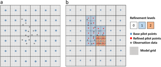
Abstract The parameterization of spatially distributed hydraulic properties is one of the most crucial steps in groundwater modeling. A common approach is to estimate hydraulic properties at a set of pilot points and interpolate the values at each model cell. Despite the popularity of this method, several questions remain about the optimum number and distribution of pilot points, which are determining factors for the efficiency of the method. This study proposes a strategy for optimal pilot point parameterization that minimizes the number of parameters while maximizing the assimilation of an observed dataset unevenly distributed in space. The performance of different pilot point distributions has been compared with a synthetic groundwater model, considering regular grids of pilot points with different spacings and adaptive grids with different refinement criteria. This work considered both prior and iterative refinements, with a parameter estimation step between successive refinements. The parameter estimation was conducted with the Gauss–Levenberg–Marquardt algorithm, and the strategies were ranked according to the number of model calls to reach the target objective function. The strategy leading to the best fit with the measurement dataset at the minimum computational burden is an adaptive grid of pilot points with prior refinement based on measurement density. This strategy was successfully implemented on a regional, multilayered groundwater flow model in the south-western geological basin of France.
Abstract Image

测量数据空间分布不均匀时不同导点参数化策略的比较
空间分布水力学特性参数化是地下水模拟的关键步骤之一。一种常见的方法是在一组导频点上估计水力特性,并在每个模型单元上插值值。尽管该方法很受欢迎,但关于导点的最佳数量和分布仍然存在几个问题,这是决定该方法效率的因素。本研究提出了一种最优导点参数化策略,该策略在最大限度地减少参数数量的同时,最大限度地同化空间分布不均匀的观测数据集。考虑不同间距导点的规则网格和不同细化准则的自适应网格,对比了不同导点分布与地下水综合模型的性能。这项工作考虑了先验和迭代改进,在连续改进之间有一个参数估计步骤。采用Gauss-Levenberg-Marquardt算法进行参数估计,并根据模型调用次数对策略进行排序,以达到目标目标函数。以最小的计算负担与测量数据集进行最佳拟合的策略是基于测量密度进行先验优化的自适应导航点网格。该策略在法国西南地质盆地的区域多层地下水流动模型中成功实施。
本文章由计算机程序翻译,如有差异,请以英文原文为准。
求助全文
约1分钟内获得全文 求助全文
来源期刊
Hydrogeology Journal
Hydrogeology Journal 地学-地球科学综合
CiteScore
5.40
自引率
7.10%
发文量
128
审稿时长
6 months
期刊介绍: Hydrogeology Journal was founded in 1992 to foster understanding of hydrogeology; to describe worldwide progress in hydrogeology; and to provide an accessible forum for scientists, researchers, engineers, and practitioners in developing and industrialized countries. Since then, the journal has earned a large worldwide readership. Its peer-reviewed research articles integrate subsurface hydrology and geology with supporting disciplines: geochemistry, geophysics, geomorphology, geobiology, surface-water hydrology, tectonics, numerical modeling, economics, and sociology.
×
引用
GB/T 7714-2015
复制
MLA
复制
APA
复制
导出至
BibTeX EndNote RefMan NoteFirst NoteExpress
×
提示
您的信息不完整,为了账户安全,请先补充。
现在去补充
×
提示
您因"违规操作"
具体请查看互助需知
我知道了
×
提示
确定
请完成安全验证×
copy
已复制链接
快去分享给好友吧!
我知道了
右上角分享
点击右上角分享
0
联系我们:info@booksci.cn Book学术提供免费学术资源搜索服务,方便国内外学者检索中英文文献。致力于提供最便捷和优质的服务体验。 Copyright © 2023 布克学术 All rights reserved.
京ICP备2023020795号-1
ghs 京公网安备 11010802042870号
Book学术文献互助
Book学术文献互助群
群 号:481959085
Book学术官方微信