Impact of Local Terrain Features on Urban Airflow
IF 2.2
3区 地球科学
Q3 METEOROLOGY & ATMOSPHERIC SCIENCES
引用次数: 0
Abstract
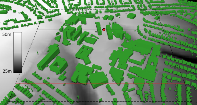
Abstract Past work has shown that coupling can exist between atmospheric air flows at street scale (O(0.1 km)) and city scale (O(10 km)). It is generally impractical at present to develop high-fidelity urban simulations capable of capturing such effects. This limitation imposes a need to develop better parameterisations for meso-scale models but an information gap exists in that past work has generally focused on simplified urban geometries and assumed the buildings to be on flat ground. This study aimed to begin to address this gap in a systematic way by using the large eddy simulation method with synthetic turbulence inflow boundary conditions to simulate atmospheric air flows over the University of Southampton campus. Both flat and realistic terrains were simulated, including significant local terrain features, such as two valleys with a width about 50 m and a depth about average building height, and a step change of urban roughness height. The numerical data were processed to obtain averaged vertical profiles of time-averaged velocities and second order turbulence statistics. The flat terrain simulation was validated against high resolution particle image velocimetry data, and the impact of uncertainty in defining the turbulence intensity in the synthetic inflow method was assessed. The ratio between realistic and flat terrains of time-mean streamwise velocity at the same ground level height over a terrain crest location can be >2, while over a valley trough it can be <0.5. Further data analysis conclusively showed that the realistic terrain can have a considerable effect on global quantities, such as the depth of the spanwise-averaged internal boundary layer and spatially-averaged turbulent kinetic energy. These highlight the potential impact that local terrain features (O(0.1 km)) may have on near-field dispersion and the urban micro-climate.

局部地形特征对城市气流的影响
过去的研究表明,街道尺度(O(0.1 km))和城市尺度(O(10 km))的大气气流之间可能存在耦合。目前,开发能够捕捉这种效果的高保真城市模拟通常是不切实际的。这一限制要求为中尺度模型开发更好的参数化,但过去的工作通常侧重于简化城市几何形状,并假设建筑物位于平坦的地面上,因此存在信息缺口。本研究旨在通过使用大涡模拟方法和合成湍流流入边界条件来模拟南安普顿大学校园上空的大气气流,以系统的方式开始解决这一差距。模拟了平坦地形和真实地形,包括两个宽度约为50 m,深度约为平均建筑高度的山谷,以及城市粗糙度高度的阶跃变化等重要的局部地形特征。对数值数据进行处理,得到时均速度的平均垂直剖面和二阶湍流统计量。利用高分辨率粒子图像测速数据对平坦地形模拟进行了验证,并评估了不确定性对综合入流方法中湍流强度定义的影响。在地形波峰位置上,相同地面高度时均水流速度的真实地形与平坦地形之比可为>2,而在谷槽位置上可为<0.5。进一步的数据分析最终表明,真实地形对全球量有相当大的影响,如展向平均内边界层深度和空间平均湍流动能。这些突出了局部地形特征(0 (0.1 km))可能对近场色散和城市小气候产生的潜在影响。
本文章由计算机程序翻译,如有差异,请以英文原文为准。
求助全文
约1分钟内获得全文
求助全文
来源期刊

Boundary-Layer Meteorology
地学-气象与大气科学
CiteScore
7.50
自引率
14.00%
发文量
72
审稿时长
12 months
期刊介绍:
Boundary-Layer Meteorology offers several publishing options: Research Letters, Research Articles, and Notes and Comments. The Research Letters section is designed to allow quick dissemination of new scientific findings, with an initial review period of no longer than one month. The Research Articles section offers traditional scientific papers that present results and interpretations based on substantial research studies or critical reviews of ongoing research. The Notes and Comments section comprises occasional notes and comments on specific topics with no requirement for rapid publication. Research Letters are limited in size to five journal pages, including no more than three figures, and cannot contain supplementary online material; Research Articles are generally fifteen to twenty pages in length with no more than fifteen figures; Notes and Comments are limited to ten journal pages and five figures. Authors submitting Research Letters should include within their cover letter an explanation of the need for rapid publication. More information regarding all publication formats can be found in the recent Editorial ‘Introducing Research Letters to Boundary-Layer Meteorology’.
 求助内容:
求助内容: 应助结果提醒方式:


