A study of the simulated climatological January mean upwelling in the northwestern Gulf of Alaska
IF 1.9
3区 地球科学
Q2 OCEANOGRAPHY
引用次数: 0
Abstract
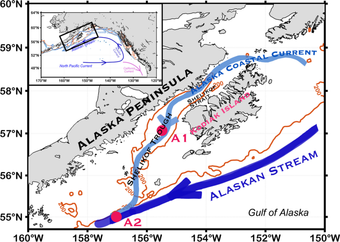
Abstract In this research, we studied the upwelling in the northwestern Gulf of Alaska using the climatological January mean and data from the output of the Ocean General Circulation Model for Earth Simulator (OFES2). Specifically, we analyzed the upwelling in the regions where the Alaska Coastal Current (ACC) flows out of the Shelikof Strait (especially the part to the west of Kodiak Island) and where the ACC and the Alaskan Stream (AS) are confluent. In both regions, strong geostrophic currents and downwelling-favorable wind predominate in winter. Furthermore, there are freshwater discharges along the Alaskan coast and an observed mean current vertical shear in the ACC. We revealed that when the internal water stress is larger than the wind stress inside the study regions, this could be decisive in terms of the local horizontal velocity divergence and further upwelling, even if the region is away from the coast and lacks upwelling-favorable wind conditions. Geostrophic stress is part of the internal water stress and is a product of the geostrophic current shear (due to the thermal wind relation) and the vertical viscosity coefficient. The analysis indicated that a front with a large geostrophic stress may act as a “virtual wall” and contribute to local upwelling within a depth of approximately 100 m in the study regions. This process could provide a heuristic for understanding the distribution of pollock in the areas during February and March, which corresponds to the simulated upwelling region.

对阿拉斯加湾西北部一月平均上升流的模拟气候研究
本文利用1月气候平均值和海洋环流模拟地球模拟器(OFES2)输出的数据,对阿拉斯加湾西北部的上升流进行了研究。具体来说,我们分析了阿拉斯加海岸流(ACC)从Shelikof海峡流出的区域(特别是Kodiak岛以西的部分)以及ACC和阿拉斯加流(AS)的汇合处的上升流。这两个地区冬季以强地转流和有利于下沉的风为主。此外,沿阿拉斯加海岸有淡水排放,并在太平洋环流中观测到平均洋流垂直切变。我们发现,当研究区域内的内部水应力大于风应力时,即使该区域远离海岸且缺乏有利于上升流的风条件,这也可能对局部水平速度辐散和进一步上升流起决定性作用。地转应力是内部水应力的一部分,是地转流切变(由于热风关系)和垂直粘度系数的乘积。分析表明,具有较大地转应力的锋面可能起到“虚拟壁面”的作用,并在研究区域约100 m深度内促进局部上升流。该过程可为了解2月和3月该区狭鳕的分布提供启发式信息,该区域与模拟的上升流区相对应。
本文章由计算机程序翻译,如有差异,请以英文原文为准。
求助全文
约1分钟内获得全文
求助全文
来源期刊

Ocean Dynamics
地学-海洋学
CiteScore
5.40
自引率
0.00%
发文量
37
审稿时长
6-12 weeks
期刊介绍:
Ocean Dynamics is an international journal that aims to publish high-quality peer-reviewed articles in the following areas of research:
Theoretical oceanography (new theoretical concepts that further system understanding with a strong view to applicability for operational or monitoring purposes);
Computational oceanography (all aspects of ocean modeling and data analysis);
Observational oceanography (new techniques or systematic approaches in measuring oceanic variables, including all aspects of monitoring the state of the ocean);
Articles with an interdisciplinary character that encompass research in the fields of biological, chemical and physical oceanography are especially encouraged.
 求助内容:
求助内容: 应助结果提醒方式:


