{"title":"Morphometric analysis of Bichom River basin, Arunachal Pradesh, India using ALOS PALSAR RTC DEM and geospatial technology","authors":"Ranjit Mahato, Gibji Nimasow","doi":"10.1007/s12518-023-00528-5","DOIUrl":null,"url":null,"abstract":"<div><p>Morphometric analysis provides an essential understanding of the geo-hydrological nature of a drainage basin. The advancements in remote sensing products like digital elevation model (DEM) and geographical information system (GIS) have made the assessment of morphometric indices more effective, easier, cheaper, and faster. Many studies have been carried out in different river basins of the country but there are meager works in context of the river basins of Arunachal Pradesh, India. Therefore, in this study, we assessed the morphometric parameters of the Bichom River basin for the first time using the DEM of Advanced Land Observing Satellite-Phased Array-Type L-Band Synthetic Aperture Radar (ALOS-PALSAR) with 12.5m spatial resolution in ArcGIS 10.3. The basin was divided into four sub-watersheds, namely Upper Bichom (SW-1), Dirang-Chu (SW-2), Tenga (SW-3), and Kaya (SW-4), and the linear, areal, and relief parameters have been analyzed. The Bichom River is of 8th order and exhibits dentritic drainage pattern. The results of linear aspects show that the basin is lithologically and geologically controlled with variations in slope and topography. The areal parameters indicate moderately permeable subsoil, moderate to high runoff with steep slope, rapid rainwater discharge, low to moderate permeability or infiltration, mature topography, and semi-circular basin. Finally, the relief attributes of the basin also exhibit steep slope, high runoff with low to moderate infiltration potential, and active erosional processes. The present baseline findings of the morphometric parameters could be effectively used by the decision-makers for prioritizing soil and water resource management at the basin and sub-watershed level.</p></div>","PeriodicalId":46286,"journal":{"name":"Applied Geomatics","volume":"15 4","pages":"853 - 870"},"PeriodicalIF":2.3000,"publicationDate":"2023-10-21","publicationTypes":"Journal Article","fieldsOfStudy":null,"isOpenAccess":false,"openAccessPdf":"","citationCount":"0","resultStr":null,"platform":"Semanticscholar","paperid":null,"PeriodicalName":"Applied Geomatics","FirstCategoryId":"1085","ListUrlMain":"https://link.springer.com/article/10.1007/s12518-023-00528-5","RegionNum":0,"RegionCategory":null,"ArticlePicture":[],"TitleCN":null,"AbstractTextCN":null,"PMCID":null,"EPubDate":"","PubModel":"","JCR":"Q2","JCRName":"REMOTE SENSING","Score":null,"Total":0}
引用次数: 0
Abstract
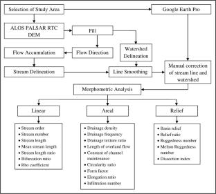
Morphometric analysis provides an essential understanding of the geo-hydrological nature of a drainage basin. The advancements in remote sensing products like digital elevation model (DEM) and geographical information system (GIS) have made the assessment of morphometric indices more effective, easier, cheaper, and faster. Many studies have been carried out in different river basins of the country but there are meager works in context of the river basins of Arunachal Pradesh, India. Therefore, in this study, we assessed the morphometric parameters of the Bichom River basin for the first time using the DEM of Advanced Land Observing Satellite-Phased Array-Type L-Band Synthetic Aperture Radar (ALOS-PALSAR) with 12.5m spatial resolution in ArcGIS 10.3. The basin was divided into four sub-watersheds, namely Upper Bichom (SW-1), Dirang-Chu (SW-2), Tenga (SW-3), and Kaya (SW-4), and the linear, areal, and relief parameters have been analyzed. The Bichom River is of 8th order and exhibits dentritic drainage pattern. The results of linear aspects show that the basin is lithologically and geologically controlled with variations in slope and topography. The areal parameters indicate moderately permeable subsoil, moderate to high runoff with steep slope, rapid rainwater discharge, low to moderate permeability or infiltration, mature topography, and semi-circular basin. Finally, the relief attributes of the basin also exhibit steep slope, high runoff with low to moderate infiltration potential, and active erosional processes. The present baseline findings of the morphometric parameters could be effectively used by the decision-makers for prioritizing soil and water resource management at the basin and sub-watershed level.
期刊介绍:
Applied Geomatics (AGMJ) is the official journal of SIFET the Italian Society of Photogrammetry and Topography and covers all aspects and information on scientific and technical advances in the geomatics sciences. The Journal publishes innovative contributions in geomatics applications ranging from the integration of instruments, methodologies and technologies and their use in the environmental sciences, engineering and other natural sciences.
The areas of interest include many research fields such as: remote sensing, close range and videometric photogrammetry, image analysis, digital mapping, land and geographic information systems, geographic information science, integrated geodesy, spatial data analysis, heritage recording; network adjustment and numerical processes. Furthermore, Applied Geomatics is open to articles from all areas of deformation measurements and analysis, structural engineering, mechanical engineering and all trends in earth and planetary survey science and space technology. The Journal also contains notices of conferences and international workshops, industry news, and information on new products. It provides a useful forum for professional and academic scientists involved in geomatics science and technology.
Information on Open Research Funding and Support may be found here: https://www.springernature.com/gp/open-research/institutional-agreements

 求助内容:
求助内容: 应助结果提醒方式:


