{"title":"Automatic urban feature extraction using rule-based object-oriented classification: a case study of parts of Pune city, Maharashtra, India","authors":"Anargha Dhorde, Gauri Deshpande, Pallavi Datkhile","doi":"10.1007/s12518-023-00527-6","DOIUrl":null,"url":null,"abstract":"<div><p>Urban areas are gaining attention globally with the implementation of the United Nations sustainable development agenda 2030 where more emphasis is given on making cities inclusive, resilient, safe, and sustainable. Hence, it is crucial to have precise data of urban built-up areas such as the shape, size, and spatial context. It is a challenging task to extract urban built-up features due to continuous modifications in land as well as heterogeneity in spatial and spectral extent of the urban surfaces. The present research attempts to extract urban built up structures using rule-based object-oriented classification. SEaTH, a tool used for feature analysis in eCognition software was applied to select the discrete features and optimum thresholds that allow more and more separability during classification. With respect to diversity in urban areas, two urban patches of Pune city were selected where one patch is the core part of the city with a congested network of roads and buildings and another patch is located in the outskirts comprises of modern multi-story buildings and relatively broad roads. Multiresolution segmentation with scale parameter of 5 with a shape 0.1 and compactness of 0.5 was finally accepted after a lot of trial iterations for both the areas. Using the SEaTH tool, some of the best object features such as shape properties, spectral bands, and indices (NDVI) were selected for the assessment of the separability and threshold. A rule-based classification was performed to acquire land use/land cover with an overall accuracy of 92% for the city core and 91% for the suburb. The k-hat value obtained was 0.81 and 0.88 for the city core and suburb area, respectively. With incorporating shape parameters in image classification, the SEaTH method applied hierarchically the shape features such as density, compactness, and shape index as the best features to separate the buildings and roads. The NDVI spectral index demonstrated in this study proved beneficial to classify vegetation features from other land use types. As a result of the present study, it has been concluded that rule-based object-oriented classification can help improve the classification of dynamic urban areas and update land use maps effectively.</p></div>","PeriodicalId":46286,"journal":{"name":"Applied Geomatics","volume":"15 4","pages":"871 - 884"},"PeriodicalIF":2.3000,"publicationDate":"2023-10-23","publicationTypes":"Journal Article","fieldsOfStudy":null,"isOpenAccess":false,"openAccessPdf":"","citationCount":"0","resultStr":null,"platform":"Semanticscholar","paperid":null,"PeriodicalName":"Applied Geomatics","FirstCategoryId":"1085","ListUrlMain":"https://link.springer.com/article/10.1007/s12518-023-00527-6","RegionNum":0,"RegionCategory":null,"ArticlePicture":[],"TitleCN":null,"AbstractTextCN":null,"PMCID":null,"EPubDate":"","PubModel":"","JCR":"Q2","JCRName":"REMOTE SENSING","Score":null,"Total":0}
引用次数: 0
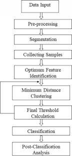
Abstract
Urban areas are gaining attention globally with the implementation of the United Nations sustainable development agenda 2030 where more emphasis is given on making cities inclusive, resilient, safe, and sustainable. Hence, it is crucial to have precise data of urban built-up areas such as the shape, size, and spatial context. It is a challenging task to extract urban built-up features due to continuous modifications in land as well as heterogeneity in spatial and spectral extent of the urban surfaces. The present research attempts to extract urban built up structures using rule-based object-oriented classification. SEaTH, a tool used for feature analysis in eCognition software was applied to select the discrete features and optimum thresholds that allow more and more separability during classification. With respect to diversity in urban areas, two urban patches of Pune city were selected where one patch is the core part of the city with a congested network of roads and buildings and another patch is located in the outskirts comprises of modern multi-story buildings and relatively broad roads. Multiresolution segmentation with scale parameter of 5 with a shape 0.1 and compactness of 0.5 was finally accepted after a lot of trial iterations for both the areas. Using the SEaTH tool, some of the best object features such as shape properties, spectral bands, and indices (NDVI) were selected for the assessment of the separability and threshold. A rule-based classification was performed to acquire land use/land cover with an overall accuracy of 92% for the city core and 91% for the suburb. The k-hat value obtained was 0.81 and 0.88 for the city core and suburb area, respectively. With incorporating shape parameters in image classification, the SEaTH method applied hierarchically the shape features such as density, compactness, and shape index as the best features to separate the buildings and roads. The NDVI spectral index demonstrated in this study proved beneficial to classify vegetation features from other land use types. As a result of the present study, it has been concluded that rule-based object-oriented classification can help improve the classification of dynamic urban areas and update land use maps effectively.
期刊介绍:
Applied Geomatics (AGMJ) is the official journal of SIFET the Italian Society of Photogrammetry and Topography and covers all aspects and information on scientific and technical advances in the geomatics sciences. The Journal publishes innovative contributions in geomatics applications ranging from the integration of instruments, methodologies and technologies and their use in the environmental sciences, engineering and other natural sciences.
The areas of interest include many research fields such as: remote sensing, close range and videometric photogrammetry, image analysis, digital mapping, land and geographic information systems, geographic information science, integrated geodesy, spatial data analysis, heritage recording; network adjustment and numerical processes. Furthermore, Applied Geomatics is open to articles from all areas of deformation measurements and analysis, structural engineering, mechanical engineering and all trends in earth and planetary survey science and space technology. The Journal also contains notices of conferences and international workshops, industry news, and information on new products. It provides a useful forum for professional and academic scientists involved in geomatics science and technology.
Information on Open Research Funding and Support may be found here: https://www.springernature.com/gp/open-research/institutional-agreements

 求助内容:
求助内容: 应助结果提醒方式:


