MIN3D Dataset: MultI-seNsor 3D Mapping with an Unmanned Ground Vehicle
IF 3.3
4区 地球科学
Q3 IMAGING SCIENCE & PHOTOGRAPHIC TECHNOLOGY
PFG-Journal of Photogrammetry Remote Sensing and Geoinformation Science
Pub Date : 2023-10-06
DOI:10.1007/s41064-023-00260-0
引用次数: 0
Abstract
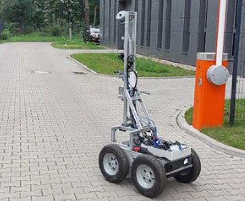
Abstract The research potential in the field of mobile mapping technologies is often hindered by several constraints. These include the need for costly hardware to collect data, limited access to target sites with specific environmental conditions or the collection of ground truth data for a quantitative evaluation of the developed solutions. To address these challenges, the research community has often prepared open datasets suitable for developments and testing. However, the availability of datasets that encompass truly demanding mixed indoor–outdoor and subterranean conditions, acquired with diverse but synchronized sensors, is currently limited. To alleviate this issue, we propose the MIN3D dataset (MultI-seNsor 3D mapping with an unmanned ground vehicle for mining applications) which includes data gathered using a wheeled mobile robot in two distinct locations: (i) textureless dark corridors and outside parts of a university campus and (ii) tunnels of an underground WW2 site in Walim (Poland). MIN3D comprises around 150 GB of raw data, including images captured by multiple co-calibrated monocular, stereo and thermal cameras, two LiDAR sensors and three inertial measurement units. Reliable ground truth (GT) point clouds were collected using a survey-grade terrestrial laser scanner. By openly sharing this dataset, we aim to support the efforts of the scientific community in developing robust methods for navigation and mapping in challenging underground conditions. In the paper, we describe the collected data and provide an initial accuracy assessment of some visual- and LiDAR-based simultaneous localization and mapping (SLAM) algorithms for selected sequences. Encountered problems, open research questions and areas that could benefit from utilizing our dataset are discussed. Data are available at https://3dom.fbk.eu/benchmarks .
MIN3D数据集:多传感器三维测绘与无人地面车辆
移动地图技术领域的研究潜力往往受到一些制约因素的阻碍。这些问题包括需要昂贵的硬件来收集数据,在特定环境条件下进入目标地点的机会有限,或者收集地面真实数据以对已开发的解决方案进行定量评估。为了应对这些挑战,研究界经常准备适合开发和测试的开放数据集。然而,数据集的可用性,包括真正苛刻的混合室内-室外和地下条件,获得不同但同步的传感器,目前是有限的。为了缓解这个问题,我们提出了MIN3D数据集(用于采矿应用的无人地面车辆的多传感器3D测绘),其中包括使用轮式移动机器人在两个不同位置收集的数据:(i)无纹理的黑暗走廊和大学校园的外部部分,以及(ii) Walim(波兰)地下二战遗址的隧道。MIN3D包含约150gb的原始数据,包括由多个协同校准的单目、立体和热像仪、两个激光雷达传感器和三个惯性测量单元捕获的图像。利用测量级地面激光扫描仪采集了可靠的地面真值点云。通过公开共享该数据集,我们的目标是支持科学界在开发具有挑战性的地下条件下导航和测绘的强大方法方面的努力。在本文中,我们描述了收集到的数据,并提供了一些基于视觉和激光雷达的同步定位和制图(SLAM)算法对选定序列的初步精度评估。讨论了遇到的问题、开放的研究问题和可以从利用我们的数据集中受益的领域。相关数据可从https://3dom.fbk.eu/benchmarks获取。
本文章由计算机程序翻译,如有差异,请以英文原文为准。
求助全文
约1分钟内获得全文
求助全文
来源期刊
PFG-Journal of Photogrammetry Remote Sensing and Geoinformation Science
Physics and Astronomy-Instrumentation
CiteScore
8.20
自引率
2.40%
发文量
38
期刊介绍:
PFG is an international scholarly journal covering the progress and application of photogrammetric methods, remote sensing technology and the interconnected field of geoinformation science. It places special editorial emphasis on the communication of new methodologies in data acquisition and new approaches to optimized processing and interpretation of all types of data which were acquired by photogrammetric methods, remote sensing, image processing and the computer-aided interpretation of such data in general. The journal hence addresses both researchers and students of these disciplines at academic institutions and universities as well as the downstream users in both the private sector and public administration.
Founded in 1926 under the former name Bildmessung und Luftbildwesen, PFG is worldwide the oldest journal on photogrammetry. It is the official journal of the German Society for Photogrammetry, Remote Sensing and Geoinformation (DGPF).
 求助内容:
求助内容: 应助结果提醒方式:


