Remnants of a Young Monogenetic Volcanic Field and the Fragile Balance of Anthropogenic Interaction
IF 2.4
2区 地球科学
Q2 GEOSCIENCES, MULTIDISCIPLINARY
引用次数: 0
Abstract
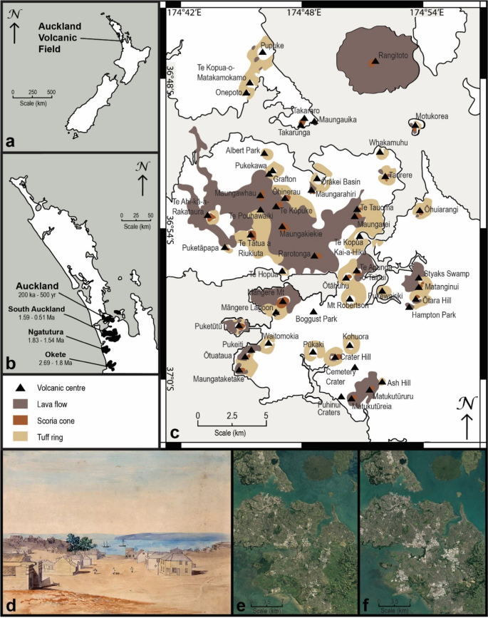
Abstract The rapid development of Auckland City in New Zealand from an initial rural settlement to a global urban hub produced a characteristic footprint on the Auckland Volcanic Field (AVF). This process was facilitated by increased anthropogenic activity that has resulted in the deterioration and destruction of many volcanic landforms and caused severe archaeological, cultural, geological and educational losses in an alarmingly short timescale. The AVF has 53 volcanic centres, and of these, 17% are classified as intact, 28% are partially intact, 30% are partially destroyed, and 25% are destroyed (including 13% that have no trace left). Based on surface area, approximately 40% of volcanic deposits in the AVF have been lost. The most common causes for impacts are public land use, quarrying and urban development. Regardless, there is significant potential to be found in the balance between the losses and gains of anthropogenic impacts on volcanic landforms. In the AVF and worldwide, geological studies have often been assisted by the presence of outcrops created by quarrying, mining, transport infrastructure and other modifications of volcanic landforms. Areas of significant volcanic geoheritage worldwide are often linked with these impacted volcanoes, and the information gained from these geoheritage areas assists in the management of geodiversity and geoeducation. Several volcanic centres are currently at risk of further destruction in the near future (Crater Hill, Waitomokia, Maugataketake, Kohuroa, Three Kings, St Heliers and McLaughlins Mt) and should be prioritised for any possible research before it is too late. We propose that a geological assessment should be a requirement before and, if possible, during any land development on or near a volcanic landform. Allowing access to scientists through the course of development in areas with volcanic landforms would, in turn, aid public and governing bodies in decision-making for the future of the city and its volcanoes in terms of increased knowledge of volcanic mechanisms of the AVF and awareness of the potential associated hazards.

年轻单成因火山场的残余物与人为相互作用的脆弱平衡
新西兰奥克兰市从最初的农村定居点到全球城市中心的快速发展在奥克兰火山场(AVF)上产生了独特的足迹。人类活动的增加促进了这一进程,导致许多火山地貌的恶化和破坏,并在令人震惊的短时间内造成了严重的考古、文化、地质和教育损失。AVF有53个火山中心,其中17%为完整的,28%为部分完整的,30%为部分破坏的,25%为完全破坏的(其中13%没有留下任何痕迹)。根据表面积计算,AVF地区大约40%的火山沉积物已经消失。造成影响的最常见原因是公共土地使用、采石和城市发展。无论如何,在火山地貌的人为影响的得失之间取得平衡是有很大潜力的。在澳大利亚和全世界,地质研究经常得到采石、采矿、运输基础设施和其他火山地貌变化所造成的露头的帮助。世界范围内具有重要火山地质遗产的地区通常与这些受影响的火山有关,从这些地质遗产地区获得的信息有助于地质多样性的管理和地质教育。几个火山中心目前面临着在不久的将来进一步破坏的风险(火山口山,怀托莫奇亚,莫加塔克,Kohuroa,三王,圣赫利斯和麦克劳克林斯山),应该优先考虑任何可能的研究,否则就太晚了。我们建议,在火山地貌上或附近进行任何土地开发之前,如果可能的话,都必须进行地质评估。在火山地貌地区的开发过程中,允许科学家进入,反过来,将有助于公共和管理机构就城市及其火山的未来做出决策,增加对AVF火山机制的了解,并提高对潜在相关危害的认识。
本文章由计算机程序翻译,如有差异,请以英文原文为准。
求助全文
约1分钟内获得全文
求助全文
来源期刊

Geoheritage
GEOSCIENCES, MULTIDISCIPLINARY-
CiteScore
5.10
自引率
34.50%
发文量
107
期刊介绍:
The Geoheritage journal is an international journal dedicated to discussing all aspects of our global geoheritage, both in situ and portable. The journal will invite all contributions on the conservation of sites and materials - use, protection and practical heritage management - as well as its interpretation through education, training and tourism.
The journal wishes to cover all aspects of geoheritage and its protection. Key topics are:
- Identification, characterisation, quantification and management of geoheritage;
- Geodiversity and geosites;
- On-site science, geological and geomorphological research:
- Global scientific heritage - key scientific geosites, GSSPs, stratotype conservation
and management;
- Scientific research and education, and the promotion of the geosciences thereby;
- Conventions, statute and legal instruments, national and international;
- Integration of biodiversity and geodiversity in nature conservation and land-use
policies;
- Geological heritage and Environmental Impact Assessment studies;
- Geological heritage, sustainable development, community action, practical initiatives and tourism;
- Geoparks: creation, management and outputs;
- Conservation in the natural world, Man-made and natural impacts, climate change;
- Geotourism definitions, methodologies, and case studies;
- International mechanisms for conservation and popularisation - World Heritage Sites,
National Parks etc.;
- Materials, data and people important in the history of science, museums, collections
and all portable geoheritage;
- Education and training of geoheritage specialists;
- Pedagogical use of geological heritage - publications, teaching media, trails, centres,
on-site museums;
- Linking the United Nations Decade of Education for Sustainable Development (2005- 2014) with geoconservation.
 求助内容:
求助内容: 应助结果提醒方式:


