Hyperspectral dimensionality reduction based on SAE-1DCNN feature selection approach
Abstract
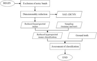
Hyperspectral remote sensing enables a detailed spectral description of the object’s surface, but it also introduces high redundancy because the narrow contiguous spectral bands are highly correlated. This has two consequences, the Hughes phenomenon and increased processing effort due to the amount of data. In the present study, it is introduced a model that integrates stacked-autoencoders and convolutional neural networks to solve the spectral redundancy problem based on the feature selection approach. Feature selection has a great advantage over feature extraction in that it does not perform any transformation on the original data and avoids the loss of information in such a transformation. The proposed model used a convolutional stacked-autoencoder to learn to represent the input data into an optimized set of high-level features. Once the SAE is learned to represent the optimal features, the decoder part is replaced with regular layers of neurons for reduce redundancy. The advantage of the proposed model is that it allows the automatic selection and extraction of representative features from a dataset preserving the meaningful information of the original bands to improve the thematic classification of hyperspectral images. Several experiments were performed using two hyperspectral data sets (Indian Pines and Salinas) belonging to the AVIRIS (Airborne Visible/Infrared Imaging Spectrometer) sensor to evaluate the performance of the proposed method. The analysis of the results showed precision and effectiveness in the proposed model when compared with other feature selection approaches for dimensionality reduction. This model can therefore be used as an alternative for dimensionality reduction.

 求助内容:
求助内容: 应助结果提醒方式:


