青海高原的年际湿度变化:趋势、模式和影响

IF 5.9 1区 地球科学 Q1 ENGINEERING, CIVIL
Yanxi Yang , Junbang Wang , Xiujuan Zhang , Hui Ye , Bin Yuan , Alan E. Watson
{"title":"青海高原的年际湿度变化:趋势、模式和影响","authors":"Yanxi Yang ,&nbsp;Junbang Wang ,&nbsp;Xiujuan Zhang ,&nbsp;Hui Ye ,&nbsp;Bin Yuan ,&nbsp;Alan E. Watson","doi":"10.1016/j.jhydrol.2024.132074","DOIUrl":null,"url":null,"abstract":"<div><div>Investigating surface dry-wet patterns on the Qinghai Plateau (QP) is crucial for water allocation, ecological sustainability, and climate variability adaptation strategies. Existing discrepancies in the QP dry-wet trends and distribution characteristics underscored the need for a more refined analysis. This study utilized the Thornthwaite Moisture Index (IM) to quantify changes in surface dryness and wetness under prevailing climatic conditions. Linear trend regression and ensemble empirical mode decomposition (EEMD) were applied to study the dynamic and periodic characteristics of the QP from 1980 to 2018.</div><div>Our findings revealed a decrease from southeast to northwest in IM, with the semi-arid and sub-humid transition line aligning closely with the 400 mm isohyet. The dry-wet transition line exhibited a northwestward trend over the past four decades. Possibly influenced by monsoon circulation and El Niño-Southern Oscillation (ENSO), the annual IM displayed a quasi-cycle of 3 to 5 years, manifested by a dry period (1990–2004) and a wet period (2005–2012). However, spatial differences existed, challenging the universality of the “Dry gets Drier and Wet gets Wetter (DDWW)” pattern. Precipitation (PRCP) changes could predict over 90 % of IM spatiotemporal variations. Additionally, the IM response to Average Temperature (TAVG) exhibited an inverted U-shaped curve, with a boundary (−3.8 °C) below which cooler regions became wetter and above which they became drier. The observed warming and precipitation shifts suggested that continued warming could lead to warmer and wetter climates, potentially causing ecological and environmental problems. Therefore, examining the surface moisture budget is of critical scientific and practical significance, in order to provide a decision-making basis for mitigating and adapting to climate change.</div></div>","PeriodicalId":362,"journal":{"name":"Journal of Hydrology","volume":"645 ","pages":"Article 132074"},"PeriodicalIF":5.9000,"publicationDate":"2024-10-20","publicationTypes":"Journal Article","fieldsOfStudy":null,"isOpenAccess":false,"openAccessPdf":"","citationCount":"0","resultStr":"{\"title\":\"Interannual moisture variability on the Qinghai Plateau: Trends, patterns, and implications\",\"authors\":\"Yanxi Yang ,&nbsp;Junbang Wang ,&nbsp;Xiujuan Zhang ,&nbsp;Hui Ye ,&nbsp;Bin Yuan ,&nbsp;Alan E. Watson\",\"doi\":\"10.1016/j.jhydrol.2024.132074\",\"DOIUrl\":null,\"url\":null,\"abstract\":\"<div><div>Investigating surface dry-wet patterns on the Qinghai Plateau (QP) is crucial for water allocation, ecological sustainability, and climate variability adaptation strategies. Existing discrepancies in the QP dry-wet trends and distribution characteristics underscored the need for a more refined analysis. This study utilized the Thornthwaite Moisture Index (IM) to quantify changes in surface dryness and wetness under prevailing climatic conditions. Linear trend regression and ensemble empirical mode decomposition (EEMD) were applied to study the dynamic and periodic characteristics of the QP from 1980 to 2018.</div><div>Our findings revealed a decrease from southeast to northwest in IM, with the semi-arid and sub-humid transition line aligning closely with the 400 mm isohyet. The dry-wet transition line exhibited a northwestward trend over the past four decades. Possibly influenced by monsoon circulation and El Niño-Southern Oscillation (ENSO), the annual IM displayed a quasi-cycle of 3 to 5 years, manifested by a dry period (1990–2004) and a wet period (2005–2012). However, spatial differences existed, challenging the universality of the “Dry gets Drier and Wet gets Wetter (DDWW)” pattern. Precipitation (PRCP) changes could predict over 90 % of IM spatiotemporal variations. Additionally, the IM response to Average Temperature (TAVG) exhibited an inverted U-shaped curve, with a boundary (−3.8 °C) below which cooler regions became wetter and above which they became drier. The observed warming and precipitation shifts suggested that continued warming could lead to warmer and wetter climates, potentially causing ecological and environmental problems. Therefore, examining the surface moisture budget is of critical scientific and practical significance, in order to provide a decision-making basis for mitigating and adapting to climate change.</div></div>\",\"PeriodicalId\":362,\"journal\":{\"name\":\"Journal of Hydrology\",\"volume\":\"645 \",\"pages\":\"Article 132074\"},\"PeriodicalIF\":5.9000,\"publicationDate\":\"2024-10-20\",\"publicationTypes\":\"Journal Article\",\"fieldsOfStudy\":null,\"isOpenAccess\":false,\"openAccessPdf\":\"\",\"citationCount\":\"0\",\"resultStr\":null,\"platform\":\"Semanticscholar\",\"paperid\":null,\"PeriodicalName\":\"Journal of Hydrology\",\"FirstCategoryId\":\"89\",\"ListUrlMain\":\"https://www.sciencedirect.com/science/article/pii/S0022169424014707\",\"RegionNum\":1,\"RegionCategory\":\"地球科学\",\"ArticlePicture\":[],\"TitleCN\":null,\"AbstractTextCN\":null,\"PMCID\":null,\"EPubDate\":\"\",\"PubModel\":\"\",\"JCR\":\"Q1\",\"JCRName\":\"ENGINEERING, CIVIL\",\"Score\":null,\"Total\":0}","platform":"Semanticscholar","paperid":null,"PeriodicalName":"Journal of Hydrology","FirstCategoryId":"89","ListUrlMain":"https://www.sciencedirect.com/science/article/pii/S0022169424014707","RegionNum":1,"RegionCategory":"地球科学","ArticlePicture":[],"TitleCN":null,"AbstractTextCN":null,"PMCID":null,"EPubDate":"","PubModel":"","JCR":"Q1","JCRName":"ENGINEERING, CIVIL","Score":null,"Total":0}
引用次数: 0

摘要

调查青海高原(QP)的地表干湿模式对于水资源分配、生态可持续性和气候变异适应战略至关重要。青海高原干湿趋势和分布特征的现有差异凸显了进行更精细分析的必要性。本研究利用索恩斯韦特水分指数(IM)来量化当前气候条件下地表干湿度的变化。我们的研究结果表明,水分指数从东南向西北递减,半干旱和亚湿润过渡线与 400 毫米等湿线紧密相连。过去 40 年间,干湿过渡线呈西北走向。可能受季风环流和厄尔尼诺-南方涛动(ENSO)的影响,年平均降水量呈现出 3 至 5 年的准周期,表现为一个干旱期(1990-2004 年)和一个湿润期(2005-2012 年)。然而,空间差异的存在,对 "旱去湿来(DDWW)"模式的普遍性提出了质疑。降水量(PRCP)的变化可以预测 90% 以上的 IM 时空变化。此外,IM 对平均气温(TAVG)的响应呈现倒 U 型曲线,以-3.8 °C 为界,低于该温度的凉爽地区变湿,高于该温度的凉爽地区变干。观测到的气候变暖和降水量变化表明,持续变暖可能导致气候变暖和变湿,从而可能引发生态和环境问题。因此,研究地表水分预算具有重要的科学和现实意义,可为减缓和适应气候变化提供决策依据。
本文章由计算机程序翻译,如有差异,请以英文原文为准。

Interannual moisture variability on the Qinghai Plateau: Trends, patterns, and implications

Interannual moisture variability on the Qinghai Plateau: Trends, patterns, and implications
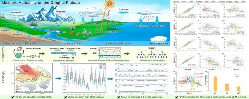
Investigating surface dry-wet patterns on the Qinghai Plateau (QP) is crucial for water allocation, ecological sustainability, and climate variability adaptation strategies. Existing discrepancies in the QP dry-wet trends and distribution characteristics underscored the need for a more refined analysis. This study utilized the Thornthwaite Moisture Index (IM) to quantify changes in surface dryness and wetness under prevailing climatic conditions. Linear trend regression and ensemble empirical mode decomposition (EEMD) were applied to study the dynamic and periodic characteristics of the QP from 1980 to 2018.
Our findings revealed a decrease from southeast to northwest in IM, with the semi-arid and sub-humid transition line aligning closely with the 400 mm isohyet. The dry-wet transition line exhibited a northwestward trend over the past four decades. Possibly influenced by monsoon circulation and El Niño-Southern Oscillation (ENSO), the annual IM displayed a quasi-cycle of 3 to 5 years, manifested by a dry period (1990–2004) and a wet period (2005–2012). However, spatial differences existed, challenging the universality of the “Dry gets Drier and Wet gets Wetter (DDWW)” pattern. Precipitation (PRCP) changes could predict over 90 % of IM spatiotemporal variations. Additionally, the IM response to Average Temperature (TAVG) exhibited an inverted U-shaped curve, with a boundary (−3.8 °C) below which cooler regions became wetter and above which they became drier. The observed warming and precipitation shifts suggested that continued warming could lead to warmer and wetter climates, potentially causing ecological and environmental problems. Therefore, examining the surface moisture budget is of critical scientific and practical significance, in order to provide a decision-making basis for mitigating and adapting to climate change.
求助全文
通过发布文献求助,成功后即可免费获取论文全文。 去求助
来源期刊
Journal of Hydrology
Journal of Hydrology 地学-地球科学综合
CiteScore
11.00
自引率
12.50%
发文量
1309
审稿时长
7.5 months
期刊介绍: The Journal of Hydrology publishes original research papers and comprehensive reviews in all the subfields of the hydrological sciences including water based management and policy issues that impact on economics and society. These comprise, but are not limited to the physical, chemical, biogeochemical, stochastic and systems aspects of surface and groundwater hydrology, hydrometeorology and hydrogeology. Relevant topics incorporating the insights and methodologies of disciplines such as climatology, water resource systems, hydraulics, agrohydrology, geomorphology, soil science, instrumentation and remote sensing, civil and environmental engineering are included. Social science perspectives on hydrological problems such as resource and ecological economics, environmental sociology, psychology and behavioural science, management and policy analysis are also invited. Multi-and interdisciplinary analyses of hydrological problems are within scope. The science published in the Journal of Hydrology is relevant to catchment scales rather than exclusively to a local scale or site.
×
引用
GB/T 7714-2015
复制
MLA
复制
APA
复制
导出至
BibTeX EndNote RefMan NoteFirst NoteExpress
×
提示
您的信息不完整,为了账户安全,请先补充。
现在去补充
×
提示
您因"违规操作"
具体请查看互助需知
我知道了
×
提示
确定
请完成安全验证×
copy
已复制链接
快去分享给好友吧!
我知道了
右上角分享
点击右上角分享
0
联系我们:info@booksci.cn Book学术提供免费学术资源搜索服务,方便国内外学者检索中英文文献。致力于提供最便捷和优质的服务体验。 Copyright © 2023 布克学术 All rights reserved.
京ICP备2023020795号-1
ghs 京公网安备 11010802042870号
Book学术文献互助
Book学术文献互助群
群 号:481959085
Book学术官方微信